
ファイル:'Confederate General Lewis Armistead at The Angle' -- Gettysburg (PA) Cyclorama 2012.jpg
元のファイル (2,397 × 1,379 ピクセル、ファイルサイズ: 703キロバイト、MIME タイプ: image/jpeg)
ウィキメディア・コモンズのファイルページにある説明を、以下に表示します。
|
_Cyclorama_2012.jpg?uselang=ja)
_Cyclorama_2012.jpg?uselang=ja)
_Cyclorama_2012.jpg?uselang=ja&action=history)
_Cyclorama_2012.jpg)
概要
| 解説 |
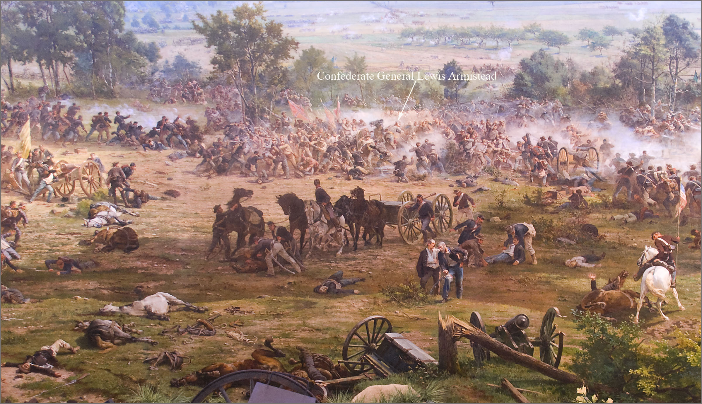
English: 'The Battle of Gettysburg', also known as the Gettysburg Cyclorama, is a cyclorama painting by the French artist Paul Philippoteaux depicting "Pickett's Charge", the climactic Confederate attack on the Union forces on Cemetery Ridge during the Battle of Gettysburg on Friday afternoon July 3, 1863.
The section of the Cyclorama shown above depicts Confederate General Lewis Armistead struck by rifle fire while leading his brigade in a break-through of the Union infantry line on Cemetery Ridge at an area known as "The Angle". Armistead's brigade arrived at Gettysburg on the evening of July 2nd. As part of the Pickett-Pettigrew Charge on the 3rd, Armistead led his brigade from the front on foot (not on a horse as portrayed above), waving his hat from the tip of his saber, and reaching and climbing over the stone wall at the "Angle", which served as the Charge's objective. Armistead was shot three times just after crossing the stone wall. However, his wounds were initially not believed to be mortal, being shot in the fleshy part of the arm and below the knee. He was eventually taken to a Union field hospital at the George Spangler Farm where he died two days later. The chief surgeon at the Union hospital there had expected Armistead to survive because he characterized the two bullet wounds as not serious. He wrote that the death "was not from his wounds directly, but from secondary fever and prostration". Image at 7:15 pm July 28, 2012, by Ron Cogswell using a hand-held Nikon D80 at 1/6 sec., f/3.5, ISO 400, and 18 mm, during an after-hours presentation on the Gettysburg Cyclorama conducted by Chris Brennaman. |
| 日付 |
Painting:1883 Photograph: 2012-07-28 |
| 原典 | https://www.flickr.com/photos/22711505@N05/7694930148/ |
| 作者 | Ron Cogswell |
| カメラの位置 | | 以下のサービスでこの位置を確認する: オープンストリートマップ |
|---|
_Cyclorama_2012.jpg¶ms=039.811568_N_-077.226054_E_globe:Earth_type:camera__&language=ja)
ライセンス
| 当初、Flickr に投稿されたこの画像は、UploadWizard 拡張機能によって査読され、コモンズに投稿された時点で、cc-by-2.0 ライセンスの下で利用可能であることが確認されました。詳しくはライセンス情報をご覧ください。 |
- あなたは以下の条件に従う場合に限り、自由に
- 共有 – 本作品を複製、頒布、展示、実演できます。
- 再構成 – 二次的著作物を作成できます。
- あなたの従うべき条件は以下の通りです。
- 表示 – あなたは適切なクレジットを表示し、ライセンスへのリンクを提供し、変更があったらその旨を示さなければなりません。これらは合理的であればどのような方法で行っても構いませんが、許諾者があなたやあなたの利用行為を支持していると示唆するような方法は除きます。
ファイルの履歴
過去の版のファイルを表示するには、その版の日時をクリックしてください。
| 日付と時刻 | サムネイル | 寸法 | 利用者 | コメント | |
|---|---|---|---|---|---|
| 現在の版 | 2013年8月18日 (日) 02:38 | | 2,397 × 1,379 (703キロバイト) | Jarekt | User created page with UploadWizard |
ファイルの使用状況
以下のページがこのファイルを使用しています:
グローバルなファイル使用状況
以下に挙げる他のウィキがこの画像を使っています:
- de.wikipedia.org での使用状況
- en-two.iwiki.icu での使用状況
- ru.wikipedia.org での使用状況
- sv.wikipedia.org での使用状況
_Cyclorama_2012.jpg)