
ファイル:Chambers Street, Edinburgh - geograph.org.uk - 1419940.jpg
高解像度版はありません。
Chambers_Street,_Edinburgh_-_geograph.org.uk_-_1419940.jpg (640 × 446 ピクセル、ファイルサイズ: 74キロバイト、MIME タイプ: image/jpeg)
ウィキメディア・コモンズのファイルページにある説明を、以下に表示します。
|
概要
| 解説 |
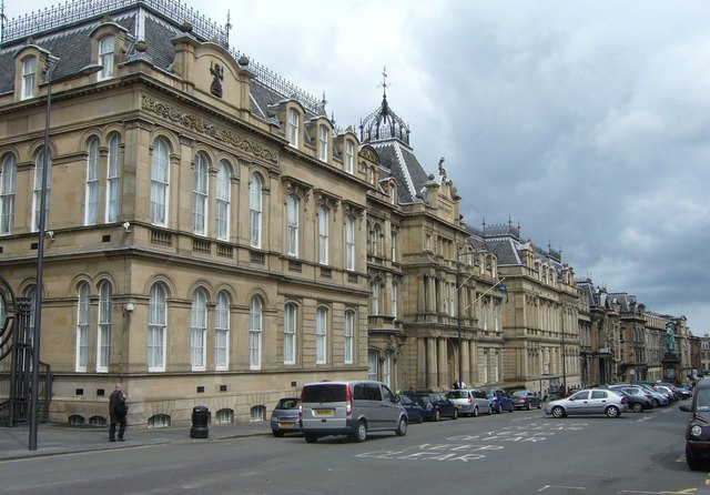
English: Chambers Street, Edinburgh. Chambers Street came about as one of the major street-planning improvements carried out in the wake of M.O.H. Henry Littlejohn's report of 1855 on sanitary conditions in the Old Town of Edinburgh. Littlejohn urged extensive slum clearance for the sake of public health which was eventually put into effect by the City Improvement Acts of 1867 and 1871. The 70-foot-wide, 1,000-foot-long street, replaced a narrow, squalid thoroughfare running alongside Old College from Adam Square at the eastern end through Argyle Square to Brown Square at the western end. These squares (along with George Square) represented the first major, southwards expansion of the town beyond its traditional boundaries before the New Town was built to the north. All three squares were demolished. The new street was named after Lord Provost William Chambers who was Littlejohn's foremost supporter in pushing for improvements. 1338463 |
| 日付 | |
| 原典 | From geograph.org.uk |
| 作者 | kim traynor |
| 帰属 (ライセンスによる要求事項) | kim traynor / Chambers Street, Edinburgh / |
| カメラの位置 | | 以下のサービスでこの位置を確認する: オープンストリートマップ |
|---|
_heading:67.00&language=ja)
| 被写体の位置 | | 以下のサービスでこの位置を確認する: オープンストリートマップ |
|---|
_heading:67.00&language=ja)
ライセンス

|
この写真はGeograph projectコレクションから提供されています。撮影者の連絡先の詳細はGeographの公式サイトにある写真ページをご覧ください。この画像の著作権はkim traynorに帰属しており、クリエイティブ・コモンズ 表示 - 継承 2.0 ライセンスの下に利用を許諾されています。
|
このファイルはクリエイティブ・コモンズ 表示-継承 2.0 一般ライセンスのもとに利用を許諾されています。
帰属: kim traynor
- あなたは以下の条件に従う場合に限り、自由に
- 共有 – 本作品を複製、頒布、展示、実演できます。
- 再構成 – 二次的著作物を作成できます。
- あなたの従うべき条件は以下の通りです。
- 表示 – あなたは適切なクレジットを表示し、ライセンスへのリンクを提供し、変更があったらその旨を示さなければなりません。これらは合理的であればどのような方法で行っても構いませんが、許諾者があなたやあなたの利用行為を支持していると示唆するような方法は除きます。
- 継承 – もしあなたがこの作品をリミックスしたり、改変したり、加工した場合には、あなたはあなたの貢献部分を元の作品とこれと同一または互換性があるライセンスの下に頒布しなければなりません。
ファイルの履歴
過去の版のファイルを表示するには、その版の日時をクリックしてください。
| 日付と時刻 | サムネイル | 寸法 | 利用者 | コメント | |
|---|---|---|---|---|---|
| 現在の版 | 2011年3月1日 (火) 15:23 | | 640 × 446 (74キロバイト) | GeographBot | == {{int:filedesc}} == {{Information |description={{en|1=Chambers Street, Edinburgh Chambers Street came about as one of the major street-planning improvements carried out in the wake of M.O.H. Henry Littlejohn's report of 1855 on sanitary conditions in t |
ファイルの使用状況
以下のページがこのファイルを使用しています:
グローバルなファイル使用状況
以下に挙げる他のウィキがこの画像を使っています:
- ar.wikipedia.org での使用状況
- azb.wikipedia.org での使用状況
- en-two.iwiki.icu での使用状況
- www.wikidata.org での使用状況
- zh-yue.wikipedia.org での使用状況