
ファイル:Cheshire UK locator map 2010.svg

この SVG ファイルのこの PNG プレビューのサイズ: 494 × 600 ピクセル. その他の解像度: 198 × 240 ピクセル | 395 × 480 ピクセル | 633 × 768 ピクセル | 843 × 1,024 ピクセル | 1,687 × 2,048 ピクセル | 1,108 × 1,345 ピクセル。
元のファイル (SVG ファイル、1,108 × 1,345 ピクセル、ファイルサイズ: 302キロバイト)
ウィキメディア・コモンズのファイルページにある説明を、以下に表示します。
|
概要
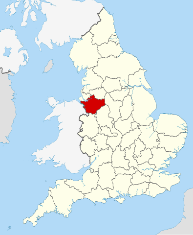
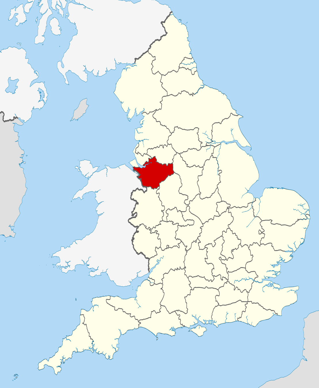
| 解説 | Location of the ceremonial county of Cheshire within England. |
| 日付 | |
| 原典 |
National Geospatial-Intelligence Agency
|
| 作者 | Nilfanion |
ライセンス
この作品の著作権者である私は、この作品を以下のライセンスで提供します。
このファイルはクリエイティブ・コモンズ 表示-継承 3.0 非移植ライセンスのもとに利用を許諾されています。
- あなたは以下の条件に従う場合に限り、自由に
- 共有 – 本作品を複製、頒布、展示、実演できます。
- 再構成 – 二次的著作物を作成できます。
- あなたの従うべき条件は以下の通りです。
- 表示 – あなたは適切なクレジットを表示し、ライセンスへのリンクを提供し、変更があったらその旨を示さなければなりません。これらは合理的であればどのような方法で行っても構いませんが、許諾者があなたやあなたの利用行為を支持していると示唆するような方法は除きます。
- 継承 – もしあなたがこの作品をリミックスしたり、改変したり、加工した場合には、あなたはあなたの貢献部分を元の作品とこれと同一または互換性があるライセンスの下に頒布しなければなりません。

|
この文書は、フリーソフトウェア財団発行のGNUフリー文書利用許諾書 (GNU Free Documentation License) 1.2またはそれ以降のバージョンの規約に基づき、複製や再配布、改変が許可されます。不可変更部分、表紙、背表紙はありません。このライセンスの複製は、GNUフリー文書利用許諾書という章に含まれています。 |
あなたは上記のライセンスから、どれか一つ以上を選択できます。

|
これは、ウィキメディア・コモンズの価値ある画像のセットであるLocator maps of the Ceremonial counties of Englandの画像形式の一部です。この画像セットは、価値ある画像セットの基準で評価され、以下の範囲内において、コモンズで最も価値あるセットだと見做されています。
Locator maps of the Ceremonial counties of England
推薦作品はCommons:Valued image candidates/Locator maps of English ceremonial countiesでご覧いただけます。 |
ファイルの履歴
過去の版のファイルを表示するには、その版の日時をクリックしてください。
| 日付と時刻 | サムネイル | 寸法 | 利用者 | コメント | |
|---|---|---|---|---|---|
| 現在の版 | 2010年11月23日 (火) 22:31 | | 1,108 × 1,345 (302キロバイト) | Nilfanion | == Summary == {{Information |Description=Location of the ceremonial county of Cheshire within England. |Source=Ordnance Survey [https://www.ordnancesurvey.co.uk/opendatadownload/products.html OpenData]: *County boundar |
ファイルの使用状況
以下の 3 ページがこのファイルを使用しています:
グローバルなファイル使用状況
以下に挙げる他のウィキがこの画像を使っています:
- af.wikipedia.org での使用状況
- an.wikipedia.org での使用状況
- ar.wikipedia.org での使用状況
- arz.wikipedia.org での使用状況
- ast.wikipedia.org での使用状況
- be-tarask.wikipedia.org での使用状況
- be.wikipedia.org での使用状況
- bg.wikipedia.org での使用状況
- br.wikipedia.org での使用状況
- br.wiktionary.org での使用状況
- ca.wikipedia.org での使用状況
- ceb.wikipedia.org での使用状況
- cs.wikipedia.org での使用状況
- de.wikipedia.org での使用状況
- el.wiktionary.org での使用状況
- en-two.iwiki.icu での使用状況
- Cheshire
- Gawsworth
- Langley, Cheshire
- Martinscroft
- Croft, Cheshire
- Birchwood Forest Park
- Culcheth Linear Park
- Lymm Dam
- Westy
- Bruche, Warrington
- Kerridge
- River Bollin
- Ollerton, Cheshire
- Wirral Hundred
- Tytherington, Cheshire
- Whiston Rural District
- Englesea-Brook
- Wilderspool
- Hermitage Green
- Lache
- Siddington, Cheshire
- Hough Green
- Ness Botanic Gardens
- Adlington, Cheshire
- Risley, Warrington
- River Lily
- Orford Park
- Chelford
- Template:Cheshire-geo-stub
- Agden, Cheshire West and Chester
- Agden, Cheshire East
- Aldersey
- Chester Castle (parish)
このファイルのグローバル使用状況を表示する。