
ファイル:Daytona International Speedway.svg

この SVG ファイルのこの PNG プレビューのサイズ: 800 × 428 ピクセル. その他の解像度: 320 × 171 ピクセル | 640 × 343 ピクセル | 1,024 × 548 ピクセル | 1,280 × 685 ピクセル | 2,560 × 1,371 ピクセル | 1,255 × 672 ピクセル。
元のファイル (SVG ファイル、1,255 × 672 ピクセル、ファイルサイズ: 34キロバイト)
ウィキメディア・コモンズのファイルページにある説明を、以下に表示します。
|
概要
| 解説 |
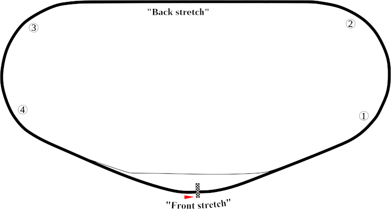
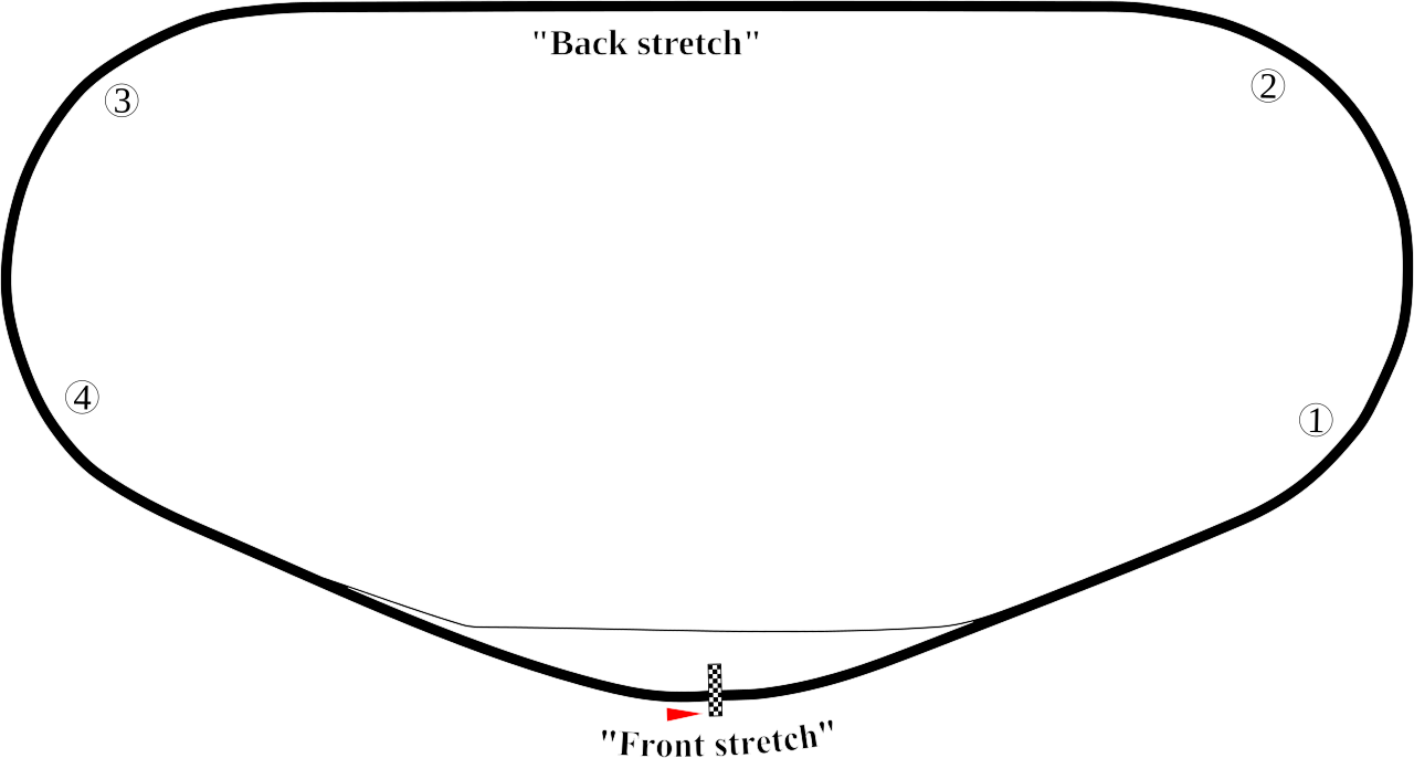
English: Track map of Daytona International Speedway showing mainly the speedway. |
| 日付 | 7-8-2008 |
| 原典 | 投稿者自身による著作物 |
| 作者 | Will Pittenger |
| その他のバージョン |
|


| カメラの位置 | | 以下のサービスでこの位置を確認する: オープンストリートマップ |
|---|
ライセンス
| この著作物の著作権者である私は、この著作物における権利を放棄しパブリックドメインとします。これは全世界で適用されます。 一部の国では、これが法的に可能ではない場合があります。その場合は、次のように宣言します。 私は、あらゆる人に対して、法により必要とされている条件を除き、如何なる条件も課すことなく、あらゆる目的のためにこの著作物を使用する権利を与えます。 |
ファイルの履歴
過去の版のファイルを表示するには、その版の日時をクリックしてください。
| 日付と時刻 | サムネイル | 寸法 | 利用者 | コメント | |
|---|---|---|---|---|---|
| 現在の版 | 2008年7月8日 (火) 10:30 | | 1,255 × 672 (34キロバイト) | Will Pittenger | This version gets around the Mediawiki bug that hides text on path objects by converting them to ordinary objects. If you need to edit the text in those objects, please use the previous version. They are the same in all other aspects. |
| 2008年7月8日 (火) 10:16 |  | 1,255 × 672 (18キロバイト) | Will Pittenger | {{Information |Description={{en|1=Track map of w:Daytona International Speedway showing mainly the speedway.}} |Source=Own work by uploader |Author=Will Pittenger |Date=7-8-2008 |Permission= |other_versions=[[Image:Daytona Int |
ファイルの使用状況
以下の 3 ページがこのファイルを使用しています:
グローバルなファイル使用状況
以下に挙げる他のウィキがこの画像を使っています:
- ast.wikipedia.org での使用状況
- de.wikipedia.org での使用状況
- en-two.iwiki.icu での使用状況
- Daytona 500
- Daytona International Speedway
- List of NASCAR tracks
- Bluegreen Vacations Duel
- Tri-oval
- Oval track racing
- Fresh From Florida 250
- Daytona 300
- 1990 Daytona 500
- Wawa 250
- 2000 Daytona 500
- 1987 Daytona 500
- 1991 Daytona 500
- 1992 Daytona 500
- 1993 Daytona 500
- 2007 Pepsi 400
- Coke Zero Sugar 400
- Hard Rock Bet 200
- 1959 Daytona 500
- List of auto racing tracks in the United States
- 1986 Daytona 500
- 1989 Daytona 500
- 1988 Daytona 500
- 2009 Budweiser Shootout
- List of Daytona 500 pole position winners
- 2010 Daytona 500
- 2009 Coke Zero 400
- List of NASCAR fatalities
- 1980 Firecracker 400
- 2011 Daytona 500
- 2011 Budweiser Shootout
- 2011 Gatorade Duels
- 1986 Firecracker 400
- 2011 Coke Zero 400
- 2012 Daytona 500
- 2012 Budweiser Shootout
- 2012 Gatorade Duels
- 1999 Pepsi 400
- 1998 Pepsi 400
- 2012 Coke Zero 400
- 2013 Sprint Unlimited
- 2013 Daytona 500
- 2004 Pepsi 400
- 2000 Daytona 250
- 2013 Budweiser Duels
このファイルのグローバル使用状況を表示する。