
ファイル:Deception Island Map.svg

この SVG ファイルのこの PNG プレビューのサイズ: 644 × 599 ピクセル. その他の解像度: 258 × 240 ピクセル | 516 × 480 ピクセル | 825 × 768 ピクセル | 1,101 × 1,024 ピクセル | 2,201 × 2,048 ピクセル | 820 × 763 ピクセル。
元のファイル (SVG ファイル、820 × 763 ピクセル、ファイルサイズ: 461キロバイト)
ウィキメディア・コモンズのファイルページにある説明を、以下に表示します。
|
| 解説 |
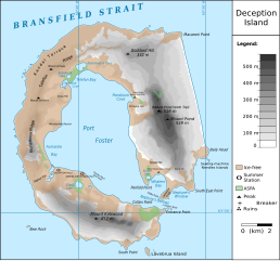
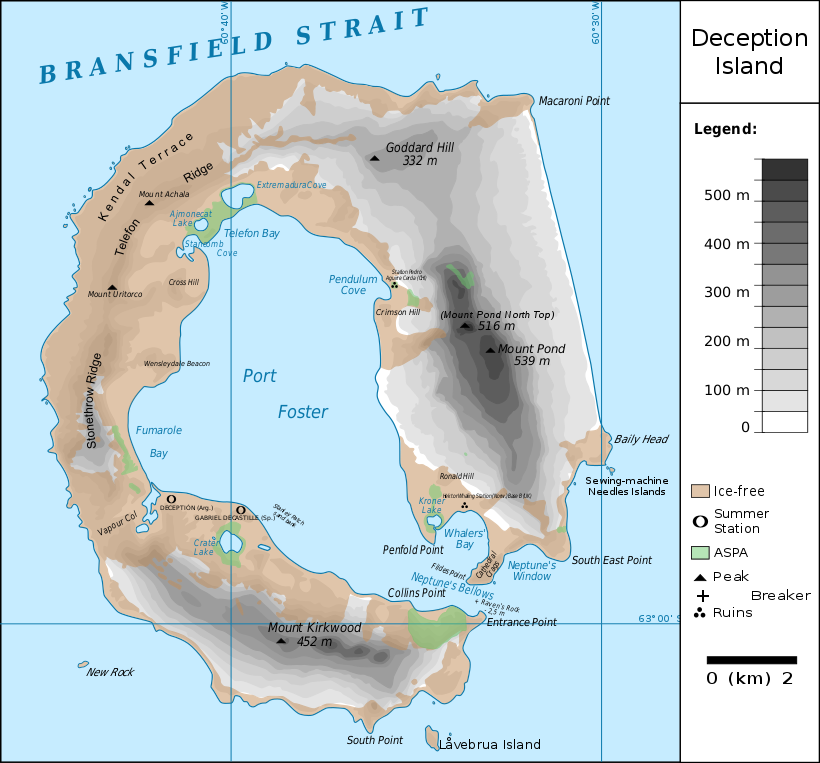
Français : carte de l'île de la Déception avec les toponymes + la position des stations ainsi que des zones protégées
English: map of Deception Island with the topography and the location of the stations and protected zones |
| 日付 | (UTC) |
| 原典 | |
| 作者 |
|
この画像には画像編集が施されています。原本に対してデジタル的な変更が行われました。
|
この作品の著作権者である私は、この作品を以下のライセンスで提供します。
このファイルはクリエイティブ・コモンズ 表示 3.0 非移植ライセンスのもとに利用を許諾されています。
- あなたは以下の条件に従う場合に限り、自由に
- 共有 – 本作品を複製、頒布、展示、実演できます。
- 再構成 – 二次的著作物を作成できます。
- あなたの従うべき条件は以下の通りです。
- 表示 – あなたは適切なクレジットを表示し、ライセンスへのリンクを提供し、変更があったらその旨を示さなければなりません。これらは合理的であればどのような方法で行っても構いませんが、許諾者があなたやあなたの利用行為を支持していると示唆するような方法は除きます。

|
この文書は、フリーソフトウェア財団発行のGNUフリー文書利用許諾書 (GNU Free Documentation License) 1.2またはそれ以降のバージョンの規約に基づき、複製や再配布、改変が許可されます。不可変更部分、表紙、背表紙はありません。このライセンスの複製は、GNUフリー文書利用許諾書という章に含まれています。 |
あなたは上記のライセンスから、どれか一つ以上を選択できます。
元のアップロードログ
This image is a derivative work of the following images:
- File:Ile_de_la_Deception.svg licensed with Cc-by-3.0, GFDL
- 2010-06-19T09:08:35Z Treehill 820x763 (464885 Bytes) carrés noirs (tentative)
- 2010-06-18T17:48:51Z Treehill 820x763 (465569 Bytes) deux dernières légendes alignées
- 2010-06-18T17:30:49Z Treehill 820x763 (465601 Bytes) nom de la baie à gauche
- 2010-06-18T17:20:48Z Treehill 820x763 (465594 Bytes) déplacement de certains textes + 1ère tentative de suppression des carrés
- 2010-06-18T14:02:39Z Treehill 820x763 (465599 Bytes) {{Information |Description={{fr|1=carte de l'île de la Déception avec les toponymes + la position des stations ainsi que des zones protégées}} |Source={{own}} |Author=[[User:Treehill|Treehill]] |Date= |Permission= |other_
Uploaded with derivativeFX
ファイルの履歴
過去の版のファイルを表示するには、その版の日時をクリックしてください。
| 日付と時刻 | サムネイル | 寸法 | 利用者 | コメント | |
|---|---|---|---|---|---|
| 現在の版 | 2018年5月13日 (日) 21:59 | | 820 × 763 (461キロバイト) | Hogweard | Rm duplicate |
| 2018年3月25日 (日) 12:45 |  | 820 × 763 (462キロバイト) | Hogweard | Corrected height of Pond North Top; Fumarole Bay and additional names. | |
| 2016年9月18日 (日) 16:35 |  | 820 × 763 (459キロバイト) | Maproom | 1.) Word "Station" no longer extends off edge of image 2.) "Peak" is spelled without a ffinal "t" 3.) "Breaker" is written in the right place instead of overwritten on "peak" | |
| 2010年10月10日 (日) 11:01 |  | 820 × 763 (459キロバイト) | Fitzgabbro | Fixed curved writing | |
| 2010年10月9日 (土) 22:11 |  | 820 × 763 (353キロバイト) | Fitzgabbro | {{Information |Description={{fr|1=carte de l'île de la Déception avec les toponymes + la position des stations ainsi que des zones protégées}} {{en|1=map of Deception Island with the topography and the location of the stations and protected zones}} |S |
ファイルの使用状況
以下のページがこのファイルを使用しています:
グローバルなファイル使用状況
以下に挙げる他のウィキがこの画像を使っています:
- ceb.wikipedia.org での使用状況
- cs.wikipedia.org での使用状況
- de.wikipedia.org での使用状況
- Deception Island
- Mount Achala
- Telefon Ridge
- Telefon Bay
- Port Foster
- Ajmonecatsee
- Stancomb Cove
- Laguna Hill
- Fildes Point
- Neptunes Bellows
- Whalers Bay
- Penfold Point
- Collins Point
- Crater Lake (Deception Island)
- Mount Kirkwood
- Entrance Point
- Crimson Hill
- Kendall Terrace
- Kroner Lake
- Låvebrua Island
- South Point (Deception Island)
- New Rock (Südliche Shetlandinseln)
- Mount Pond
- Primero de Mayo Bay
- Ravn Rock
- Ronald Hill
- South East Point
- Stonethrow Ridge
- Vapour Col
- en-two.iwiki.icu での使用状況
- eu.wikipedia.org での使用状況
- it.wikipedia.org での使用状況
- lld.wikipedia.org での使用状況
- nds.wikipedia.org での使用状況
- nl.wikipedia.org での使用状況
- nn.wikipedia.org での使用状況
- pl.wikipedia.org での使用状況
- ru.wikipedia.org での使用状況
このファイルのグローバル使用状況を表示する。