
ファイル:Emancipation Proclamation.PNG
このプレビューのサイズ: 800 × 520 ピクセル。 その他の解像度: 320 × 208 ピクセル | 640 × 416 ピクセル | 1,024 × 665 ピクセル | 1,513 × 983 ピクセル。
元のファイル (1,513 × 983 ピクセル、ファイルサイズ: 54キロバイト、MIME タイプ: image/png)
ウィキメディア・コモンズのファイルページにある説明を、以下に表示します。
|

|
このhistorical map画像は、ベクターイメージである SVG ファイルとして再作成されるべきです。これにはいくつかの利点があります。詳しくはCommons:Media for cleanupを参照してください。この画像の SVG 形式がすでに利用可能である場合は、アップロードしてください。アップロード後、この画像にあるこのテンプレートを{{Vector version available|新しい画像ファイル名.svg}}テンプレートで置き換えてください。
|
概要
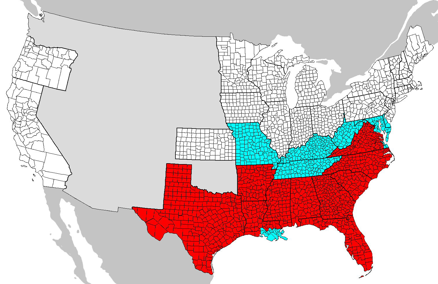
| 解説 | Map of counties covered (red) and not covered (blue) by the Emancipation Proclamation. Map needs updating as these county boundaries reflect modern boundaries and not those during 1862, with some counties displayed on this map not existing at the time. |
| 日付 | (UTC) |
| 原典 | |
| 作者 |
|
この画像には画像編集が施されています。原本に対して次のデジタル的な変更が行われました。
|

|
この文書は、フリーソフトウェア財団発行のGNUフリー文書利用許諾書 (GNU Free Documentation License) 1.2またはそれ以降のバージョンの規約に基づき、複製や再配布、改変が許可されます。不可変更部分、表紙、背表紙はありません。このライセンスの複製は、GNUフリー文書利用許諾書という章に含まれています。 |
| このファイルはクリエイティブ・コモンズ 表示-継承 3.0 非移植ライセンスのもとに利用を許諾されています。 | ||
| ||
| このライセンスのテンプレートは、GFDLのライセンス・アップデートによりこのファイルに追加されたものです。 |
== 元のアップロードログ == blue This image is a derivative work of the following images:
- Image:Map_of_USA_with_county_outlines.png licensed with GFDL
- 2008-01-23T04:41:16Z Speight 1513x983 (100713 Bytes) Fix San Francisco Bay and Puget Sound
- 2006-11-23T22:53:51Z Ibagli 1513x983 (169345 Bytes) more fixes
- 2006-11-23T22:53:05Z Ibagli 1513x983 (169416 Bytes) Reverted to earlier revision
- 2006-11-23T22:52:41Z Ibagli 1513x983 (184378 Bytes) more fixes
- 2006-11-23T02:16:28Z Ibagli 1513x983 (169416 Bytes) fix lake St. Clair
- 2005-08-28T20:57:13Z Huhsunqu 1513x983 (169340 Bytes) *{{es}} Mapa de los [[Estados Unidos de América]] mostrando los los límites de estados miembros y sus condados. Versión a colores de la adaptación hecha por [[en:User:Wapcaplet|Wapcaplet]] del mapa de dominio público del
Uploaded with derivativeFX
ファイルの履歴
過去の版のファイルを表示するには、その版の日時をクリックしてください。
| 日付と時刻 | サムネイル | 寸法 | 利用者 | コメント | |
|---|---|---|---|---|---|
| 現在の版 | 2020年6月14日 (日) 00:46 | | 1,513 × 983 (54キロバイト) | JasonAQuest | remove non-states |
| 2008年6月1日 (日) 04:31 |  | 1,513 × 983 (171キロバイト) | SFGiants | {{Information |Description=== Summary == Map of counties covered and not covered by the Emancipation Proclamation. |Source=*Image:Map_of_USA_with_county_outlines.png |Date=2008-06-01 04:29 (UTC) |Author=*derivative w |
ファイルの使用状況
以下のページがこのファイルを使用しています:
グローバルなファイル使用状況
以下に挙げる他のウィキがこの画像を使っています:
- cs.wikipedia.org での使用状況
- da.wikipedia.org での使用状況
- el.wikipedia.org での使用状況
- en-two.iwiki.icu での使用状況
- en.wikibooks.org での使用状況
- fi.wikipedia.org での使用状況
- fr.wikipedia.org での使用状況
- he.wikipedia.org での使用状況
- it.wikipedia.org での使用状況
- ko.wikipedia.org での使用状況
- simple.wikipedia.org での使用状況
- sr.wikipedia.org での使用状況
- zh-two.iwiki.icu での使用状況