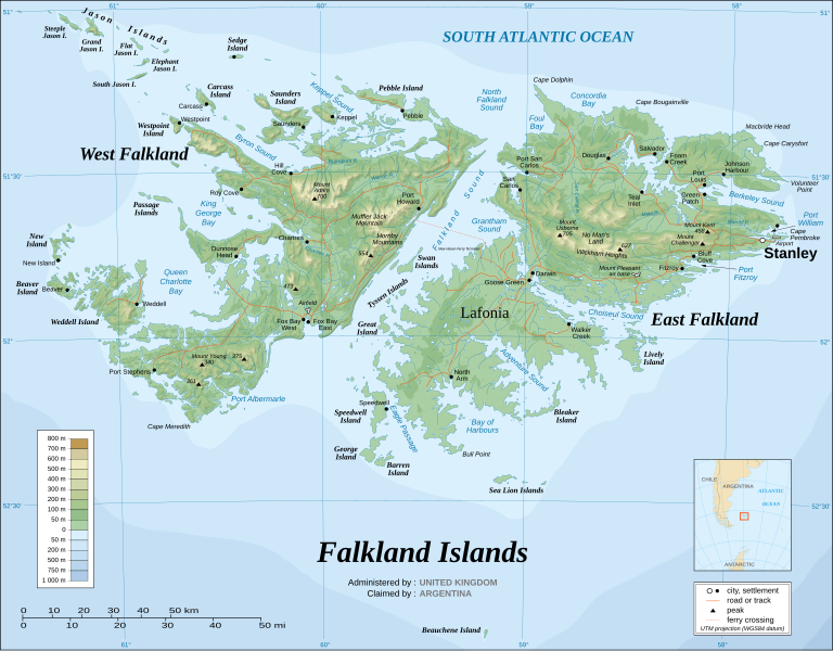
ファイル:Falkland Islands topographic map-en.svg
ページのコンテンツが他言語でサポートされていません。

元のファイル(SVG ファイル、2,550 × 1,990 ピクセル、ファイルサイズ: 1.97メガバイト)

Required raster 
  This SVG map uses required raster graphics to show delicate structures.
静止画 of the year
静止画 of the year
秀逸な静止画

ウィキメディア・コモンズウィキペディア

このファイルは年間画像大賞2007 の候補作品でした。
このファイルはウィキメディア・コモンズで秀逸な画像 (秀逸な画像) であり、 もっとも質の高い画像のひとつだと評価されています。

 このファイルは英語版ウィキペディアで秀逸な画像 (Featured pictures) であり、 もっとも質の高い画像のひとつだと評価されています。

もしあなたが同じくらい品質が高く、適切なライセンスの下に公開できるファイルをお持ちならば、ぜひアップロードして、著作権情報を表示し、推薦しましょう。


Pour agrandir l'image

Detailed map of large dimension. For a better viewing, click on the link of the image above.
Carte détaillée de grande dimension. Pour une visualisation optimale, cliquer sur le lien de l'image ci-dessus.

概要

記述
English: The Falkland Islands are an archipelago in the South Atlantic Ocean, located 300 miles off the coast of Argentina. They consist of two main islands, East Falkland and West Falkland, together with about 700 smaller islands. Stanley, on East Falkland, is the capital and largest city. The islands are a self-governing Overseas Territory of the United Kingdom.
Français : Carte topographique en anglais des Îles Malouines. Les Malouines forment un archipel dans l'Océan Atlantique Sud à 480 km des côtes argentines. Il est composé de deux îles principales, East Falkland et West Falkland, et de 700 autres îles et îlots. Stanley, sur East Falkland, est la capitale et la plus grande agglomération de l'archipel. Les Malouines sont un territoire autonome du Royaume-Uni.
Nederlands: Topografische kaart van de Falklandeilanden, een Brits overzees gebiedsdeel in de Zuidelijke Atlantische Oceaan. De archipel bestaat uit twee hoofdeilanden en ongeveer 700 kleinere op ongeveer 300 kilometer uit de kust van Argentinië. Stanley op het eiland 'East Falkland' is de hoofdstad en tergelijkertijd de meest bevolkte gemeente van het eilandengroep.De eilanden zijn een 'self-governing Overseas Territory' van het Verenigd Koninkrijk van Groot-Brittannië en Noord-Ierland.
Português: Mapa topográfico (em inglês) das Ilhas Malvinas, um arquipélago no sul do Oceano Atlântico, a 300 milhas da costa da Argentina. Consiste de duas ilhas, Soledad a leste e Gran Malvina, a oeste, junto com cerca de 700 outras ilhotas. A capital (e maior cidade) é Stanley. As Malvinas são um território autónomo do Reino Unido.
SVG 開発
InfoField
W3C grn 
このSVGのソースコードは正しい
Inkscape-yes 
この ベクター画像Inkscapeで作成されました。
{| cellspacing="8" cellpadding="0" style="clear:both; width:100%; margin:0.5em auto; border:2px solid #88A; background-color:#F7F8FF;" lang="ja" dir="ltr"

|align="center"|このファイルを翻訳

|width="100%"|

このSVGファイルには翻訳可能な埋め込みテキストが含まれています。SVG翻訳ツールや他のSVGエディタを使用して自分の言語に翻訳可能です。詳しくはSVGファイルの翻訳についてを参照してください。

|}
日付 November 2007 using elements from the original version of April 2007
原典 Own work ;
Topographic map : NASA Shuttle Radar Topography Mission (SRTM3 v.2) (public domain) edited with dlgv32 Pro/Global Mapper and vectorized with Inkscape ; UTM projection ; WGS84 datum ; shaded relief (composite image of N-W, W and N lightning positions) ;
Approximate scale of topographic data and shore / lakes limits : 1:705,000 ; of the bathymetry : 1:3.720.000
Bathymetry : USGov public domain data provided by the Demis add-on for World Wind (see the approval e-mail) ;
Other references used for additional data :
* UK government map ;
* NASA World Wind ;
* CIA map available on the site of the University of Texas at Austin ;
* Microsoft Encarta atlas (1999 edition).
Note : The shaded relief is a raster image embedded in the SVG file which increases its size. If you want a lighter map for other purposes, delete the shaded relief image in your file.
作者
Eric Gaba (Sting - fr:Sting)
許可
(ファイルの再利用)
Attribution and Share-Alike required
Georeferencing Georeference the map in Wikimaps Warper If inappropriate please set warp_status = skip to hide.
その他のバージョン

このファイルの派生的著作物:

[編集]


ライセンス

この作品の著作権者である私は、この作品を以下のライセンスで提供します。
GNU head この文書は、フリーソフトウェア財団発行のGNUフリー文書利用許諾書 (GNU Free Documentation License) 1.2またはそれ以降のバージョンの規約に基づき、複製や再配布、改変が許可されます。不可変更部分、表紙、背表紙はありません。このライセンスの複製は、GNUフリー文書利用許諾書という章に含まれています。
w:ja:クリエイティブ・コモンズ
表示 継承
このファイルはクリエイティブ・コモンズ 表示-継承 3.0 非移植ライセンスのもとに利用を許諾されています。
あなたは以下の条件に従う場合に限り、自由に
  • 共有 – 本作品を複製、頒布、展示、実演できます。
  • 再構成 – 二次的著作物を作成できます。
あなたの従うべき条件は以下の通りです。
  • 表示 – あなたは適切なクレジットを表示し、ライセンスへのリンクを提供し、変更があったらその旨を示さなければなりません。これらは合理的であればどのような方法で行っても構いませんが、許諾者があなたやあなたの利用行為を支持していると示唆するような方法は除きます。
  • 継承 – もしあなたがこの作品をリミックスしたり、改変したり、加工した場合には、あなたはあなたの貢献部分を元の作品とこれと同一または互換性があるライセンスの下に頒布しなければなりません。
このライセンスのテンプレートは、GFDLのライセンス・アップデートによりこのファイルに追加されたものです。
w:ja:クリエイティブ・コモンズ
表示 継承
このファイルはクリエイティブ・コモンズ 表示-継承 2.5 一般2.0 一般1.0 一般のライセンスのもとに利用を許諾されています。
あなたは以下の条件に従う場合に限り、自由に
  • 共有 – 本作品を複製、頒布、展示、実演できます。
  • 再構成 – 二次的著作物を作成できます。
あなたの従うべき条件は以下の通りです。
  • 表示 – あなたは適切なクレジットを表示し、ライセンスへのリンクを提供し、変更があったらその旨を示さなければなりません。これらは合理的であればどのような方法で行っても構いませんが、許諾者があなたやあなたの利用行為を支持していると示唆するような方法は除きます。
  • 継承 – もしあなたがこの作品をリミックスしたり、改変したり、加工した場合には、あなたはあなたの貢献部分を元の作品とこれと同一または互換性があるライセンスの下に頒布しなければなりません。
あなたは上記のライセンスから、どれか一つ以上を選択できます。

キャプション

このファイルの内容を1行で記述してください

このファイルに描写されている項目

題材

ファイルの履歴

過去の版のファイルを表示するには、その版の日時をクリックしてください。

(最新 | 最古) (以後の10件 | ) (10 | 20 | 50 | 100 | 250 | 500 件) を表示
日付と時刻サムネイル寸法利用者コメント
現在の版2021年8月23日 (月) 02:512021年8月23日 (月) 02:51時点における版のサムネイル2,550 × 1,990 (1.97メガバイト)Praça de MaioFile uploaded using svgtranslate tool (https://svgtranslate.toolforge.org/). Added translation for tr.
2021年8月23日 (月) 02:502021年8月23日 (月) 02:50時点における版のサムネイル2,550 × 1,990 (1.97メガバイト)Praça de MaioFile uploaded using svgtranslate tool (https://svgtranslate.toolforge.org/). Added translation for tr.
2017年4月6日 (木) 11:542017年4月6日 (木) 11:54時点における版のサムネイル2,550 × 1,990 (1.91メガバイト)RaviC+ New Haven Ferry
2008年12月19日 (金) 18:382008年12月19日 (金) 18:38時点における版のサムネイル2,550 × 1,990 (1.93メガバイト)StingReverted to version as of 03:38, 14 November 2007: please upload the translated version under a specific name
2008年12月19日 (金) 18:262008年12月19日 (金) 18:26時点における版のサムネイル2,550 × 1,990 (1.93メガバイト)Vitekthis is just croatian translation
2007年11月14日 (水) 03:382007年11月14日 (水) 03:38時点における版のサムネイル2,550 × 1,990 (1.93メガバイト)StingNew version more accurate and with shaded relief
2007年6月16日 (土) 01:182007年6月16日 (土) 01:18時点における版のサムネイル2,550 × 1,990 (1.03メガバイト)StingReverted to earlier revision
2007年6月16日 (土) 01:032007年6月16日 (土) 01:03時点における版のサムネイル2,550 × 1,990 (2.14メガバイト)StingTrying to fix the bug on WP-en #8
2007年6月16日 (土) 00:402007年6月16日 (土) 00:40時点における版のサムネイル2,550 × 1,990 (2.01メガバイト)StingTrying to fix the bug on WP-en #7 (really boring...)
2007年6月16日 (土) 00:292007年6月16日 (土) 00:29時点における版のサムネイル2,550 × 1,990 (2.08メガバイト)StingTrying to fix the bug on WP-en #6 (OK, the problem comes from the shaded relief raster image)
(最新 | 最古) (以後の10件 | ) (10 | 20 | 50 | 100 | 250 | 500 件) を表示

グローバルなファイル使用状況

以下に挙げる他のウィキがこの画像を使っています:

このファイルのグローバル使用状況を表示する。

メタデータ