
ファイル:German and Japanese spheres of influence at greatest extent World War II 1942.jpg

このプレビューのサイズ: 800 × 471 ピクセル。 その他の解像度: 320 × 188 ピクセル | 640 × 377 ピクセル | 877 × 516 ピクセル。
元のファイル (877 × 516 ピクセル、ファイルサイズ: 172キロバイト、MIME タイプ: image/jpeg)
ウィキメディア・コモンズのファイルページにある説明を、以下に表示します。
|

|
このmilitary map画像は、ベクターイメージである SVG ファイルとして再作成されるべきです。これにはいくつかの利点があります。詳しくはCommons:Media for cleanupを参照してください。この画像の SVG 形式がすでに利用可能である場合は、アップロードしてください。アップロード後、この画像にあるこのテンプレートを{{Vector version available|新しい画像ファイル名.svg}}テンプレートで置き換えてください。
|


| 解説 |
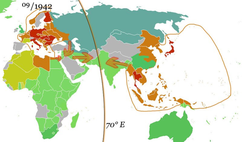
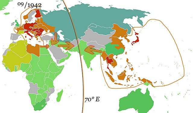
English: The German and the Japanese direct spheres of influence at their greatest extents during the Second World War in fall 1942. Arrows show planned movements to an agreed demarcation line at 70° E, which was, however, never even approximated.
The Allied countries.
Colonies, occupied territories and sphere of influence of the Allies.
The Axis countries.
Colonies, occupied territories and sphere of influence of the Axis
Vichy France and her remaining colonies.
The Soviet Union, its satellite states and sphere of influence.
Neutral countries. Deutsch: Die japanischen und deutschen direkten Einflusssphären während des zweiten Weltkrieges zum Zeitpunkt ihrer größten Ausdehnung im Herbst 1942. Pfeile zeigen geplante Bewegungen in Richtung einer vereinbarten Demarkationslinie entlang 70° östl. Länge, welche jedoch nie auch nur ansatzweise erreicht wurde.
Alliierte
Kolonien, besetzte Gebiete und Einflussbereiche der Alliierten
Achsenmächte
Kolonien, besetzte Gebiete und Einflussbereiche der Achse
Vichy-Frankreich und verbliebene Kolonien
Sowjetunion, ihre Satellitenstaaten und Einflussbereiche
Neutrale Staaten Русский: Немецкая и японская прямые сферы влияния достигли наибольшей степени во время Второй мировой войны осенью 1942 года. Стрелки показывают запланированные перемещения к согласованной демаркационной линии на 70° восточной долготы, которая, однако, никогда даже приблизительно не была определена.
Страны союзников.
Колонии, оккупированные территории и сферы влияния союзников.
Страны «Оси».
Колонии, оккупированные территории и сферы влияния стран Оси
Вишистская Франция и её оставшиеся колонии.
Советский Союз, его государства-сателлиты и сфера влияния.
Нейтральные страны. |
| 日付 | (UTC) |
| 原典 | |
| 作者 |
|
この画像には画像編集が施されています。原本に対して次のデジタル的な変更が行われました。
|
この作品の著作権者である私は、この作品を以下のライセンスで提供します。
| このファイルはクリエイティブ・コモンズ 表示-継承 3.0 非移植ライセンスのもとに利用を許諾されています。 | ||
| ||
| このライセンスのテンプレートは、GFDLのライセンス・アップデートによりこのファイルに追加されたものです。 |

|
この文書は、フリーソフトウェア財団発行のGNUフリー文書利用許諾書 (GNU Free Documentation License) 1.2またはそれ以降のバージョンの規約に基づき、複製や再配布、改変が許可されます。不可変更部分、表紙、背表紙はありません。このライセンスの複製は、GNUフリー文書利用許諾書という章に含まれています。 |
あなたは上記のライセンスから、どれか一つ以上を選択できます。
元のアップロードログ
This image is a derivative work of the following images:
- File:Ww2 allied axis.gif licensed with Cc-by-sa-3.0-migrated, GFDL
- 2010-04-07T22:14:13Z Hohum 1357x628 (106307 Bytes) Reverted to version as of 20:16, 25 November 2009 - problem is the wiki - not the image
- 2010-04-07T22:13:37Z Hohum 1357x628 (594030 Bytes) Reverted to version as of 17:47, 8 May 2009 - attempt to fix thumbnail
- 2009-11-25T20:16:27Z Bruce89 1357x628 (106307 Bytes) Optimised, some of it could be trimmed further
- 2009-05-08T17:47:59Z Rülpsmann 1357x628 (594030 Bytes) Reverted to version as of 08:29, 4 December 2006
- 2009-05-08T17:37:53Z Rülpsmann 1357x628 (594030 Bytes) less confusing, easier to understand if you think
- 2007-09-23T21:28:58Z Parhamr 1357x725 (272876 Bytes) this visual timeline communicates not only the dates but has some "visual context" of the time passed
- 2006-12-30T07:54:11Z Nxx 1357x628 (415308 Bytes) Reverted to earlier revision
- 2006-12-04T08:29:07Z Roke 1357x628 (594030 Bytes) use orange/green colours of original map
- 2006-05-19T04:36:35Z Roke 1357x628 (415308 Bytes) try version with sep 45 map, may not work as had problems
- 2006-05-18T20:04:37Z Roke 1357x628 (394879 Bytes) minor fix of some white lines in one frame
- 2006-05-18T19:38:30Z Roke 1357x628 (394934 Bytes) Western allies (blue), Soviet & allies (red) and Axis including Vichy French (black) during the [[w:Second World War|Second World War]]. Based on GNU image [[:Image:WWII.png]] [[Category:WWII maps (World)]] {{GFDL-self}}
Uploaded with derivativeFX
ファイルの履歴
過去の版のファイルを表示するには、その版の日時をクリックしてください。
| 日付と時刻 | サムネイル | 寸法 | 利用者 | コメント | |
|---|---|---|---|---|---|
| 現在の版 | 2010年10月15日 (金) 10:05 | | 877 × 516 (172キロバイト) | 36ophiuchi~commonswiki | {{Information |Description={{en|The German and the Japanese direct spheres of influence at their greatest extents during the Second World War in fall 1942. Arrows show planned movements to an agreed demarcation line at 70° E, which was, however, never ev |
ファイルの使用状況
以下の 2 ページがこのファイルを使用しています:
グローバルなファイル使用状況
以下に挙げる他のウィキがこの画像を使っています:
- af.wikipedia.org での使用状況
- ar.wikipedia.org での使用状況
- arz.wikipedia.org での使用状況
- bcl.wikipedia.org での使用状況
- be.wikipedia.org での使用状況
- ca.wikipedia.org での使用状況
- de.wikipedia.org での使用状況
- el.wikipedia.org での使用状況
- en-two.iwiki.icu での使用状況
- es.wikipedia.org での使用状況
- fa.wikipedia.org での使用状況
- fr.wikipedia.org での使用状況
- hy.wikipedia.org での使用状況
- id.wikipedia.org での使用状況
- it.wikipedia.org での使用状況
- kk.wikipedia.org での使用状況
- ko.wikipedia.org での使用状況
- lv.wikipedia.org での使用状況
- mk.wikipedia.org での使用状況
- nds.wikipedia.org での使用状況
- nl.wikipedia.org での使用状況
- ru.wikipedia.org での使用状況
- uk.wikipedia.org での使用状況
- uz.wikipedia.org での使用状況
- www.wikidata.org での使用状況
- zh-two.iwiki.icu での使用状況