
ファイル:GrahamLandstubmap.png
高解像度版はありません。
GrahamLandstubmap.png (243 × 334 ピクセル、ファイルサイズ: 30キロバイト、MIME タイプ: image/png)
ウィキメディア・コモンズのファイルページにある説明を、以下に表示します。
|
概要
| 解説 |
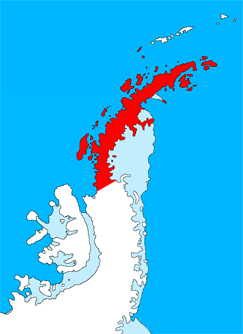
English: Outline map of the Antarctic Peninsula showing Graham Land.
Drawn by me (User:Grutness) based on File:Ant-pen_map.png by Giovanni Fattori. |
| 日付 | 2011年7月2日 (当初のアップロード日) |
| 原典 | en.wikipedia からコモンズに移動されました。 |
| 作者 | オリジナルのアップロード者は英語版ウィキペディアのGrutnessさん |
ライセンス

|
この文書は、フリーソフトウェア財団発行のGNUフリー文書利用許諾書 (GNU Free Documentation License) 1.2またはそれ以降のバージョンの規約に基づき、複製や再配布、改変が許可されます。不可変更部分、表紙、背表紙はありません。このライセンスの複製は、GNUフリー文書利用許諾書という章に含まれています。 |
元のアップロードログ
元のファイルページはこちら。以下の利用者は全てen.wikipediaに属します。
- 2011-07-02 09:38 Grutness 243×334× (30925 bytes) Outline map of the Antarctic Peninsula showing [[Graham Land]]. Drawn by me (User:Grutness) based on [[:File:Ant-pen_map.png]] by Giovanni Fattori.{{GFDL}}
ファイルの履歴
過去の版のファイルを表示するには、その版の日時をクリックしてください。
| 日付と時刻 | サムネイル | 寸法 | 利用者 | コメント | |
|---|---|---|---|---|---|
| 現在の版 | 2011年7月9日 (土) 20:06 | | 243 × 334 (30キロバイト) | MGA73bot2 | {{BotMoveToCommons|en.wikipedia|year={{subst:CURRENTYEAR}}|month={{subst:CURRENTMONTHNAME}}|day={{subst:CURRENTDAY}}}} {{Information |Description={{en|Outline map of the Antarctic Peninsula showing en:Graham Land. Drawn by me (User:Grutness) base |
ファイルの使用状況
グローバルなファイル使用状況
以下に挙げる他のウィキがこの画像を使っています:
- az.wikipedia.org での使用状況
- bg.wikipedia.org での使用状況
- cs.wikipedia.org での使用状況
- da.wikipedia.org での使用状況
- de.wikipedia.org での使用状況
- en-two.iwiki.icu での使用状況
- Mount Scott (Antarctica)
- Bowman Coast
- Bearing Island
- Enterprise Island
- Cuverville Island
- Danco Island
- Reclus Peninsula
- Charlotte Bay
- Loubet Coast
- Rongé Island
- Mill Inlet
- Cabinet Inlet
- Cape Alexander
- Cole Peninsula
- Castle Peak (Antarctica)
- Quartermain Glacier
- Quervain Peak
- Aagaard Glacier
- Leonardo Glacier
- Bigourdan Fjord
- Cape Jeremy
- Weertman Island
- Bennett Islands
- Liard Island
- Arctowski Peninsula
- Devil Island
- Upper Island
- Useful Island
- Mount Zdarsky
- Mount Shackleton
- Shag Rock (Antarctica)
- Shanty Point
- Sharp Glacier
- Mount Shelby
- Mount St. Louis
- Shull Rocks
- Simler Snowfield
- Zapato Point
このファイルのグローバル使用状況を表示する。