コンテンツにスキップ

英文维基 | 中文维基 | 日文维基 | 草榴社区

ファイル:Howland island nasa.jpg

ページのコンテンツが他言語でサポートされていません。

Howland_island_nasa.jpg (540 × 540 ピクセル、ファイルサイズ: 51キロバイト、MIME タイプ: image/jpeg)

概要

解説
Deutsch: NASA-Astronautenbild der Howlandsinsel im Pazifischen Ozean
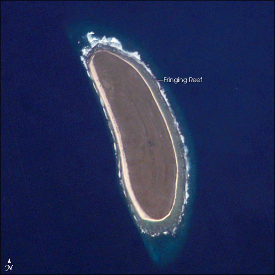
English: NASA astronaut image of Howland Island in the Pacific Ocean


International Space Station InsigniaISS Crew Earth Observations: ISS010-E-9287International Space Station emblem
Identification
Mission ISS010 (Expedition 10)
Roll E
Frame 9287
Country or Geographic Name HOWLAND ISLAND
Features HOWLAND ISLAND
Center Point Latitude 0.8° N
Center Point Longitude -176.6° E
Camera
Camera Tilt 41°
Camera Focal Length 800 mm
Camera Kodak DCS760C Electronic Still Camera
Film 3060 x 2036 pixel CCD, RGBG array.
Quality
Percentage of Cloud Cover 0-10%
Nadir What is Nadir?
Date 2004-12-03
Time 18:55:48
Nadir Point Latitude 2.7° N
Nadir Point Longitude -174.6° E
Nadir to Photo Center Direction Southwest
Sun Azimuth 115°
Spacecraft Altitude 192 nautical miles (356 km)
Sun Elevation Angle 19°
Orbit Number 2496
Original image caption
Howland Island is a United States possession located in the north Pacific between Australia and the Hawaiian Islands. Prior to 1890, organic nitrate (guano) was mined from the island by both the United States and the British. This tiny island (1.6 km2) is currently part of the U.S. National Wildlife Refuge system, and provides nesting areas and forage for a variety of birds and marine wildlife.

The island is composed of coral fragments and is surrounded by an active fringing reef. White breakers encircling the island indicate the position of the reef. Astronauts aboard the International Space Station photograph numerous reefs around the world as part of a global mapping and monitoring program. High-resolution images such as this one are used to update geographic maps of reefs and islands, assess the health of reef ecosystems, and calculate bathymetry of the surrounding ocean bottom.

日付
原典 http://earthobservatory.nasa.gov/Newsroom/NewImages/Images/ISS010-E-9287_lrg.jpg
作者 NASA
許可
(ファイルの再利用)
Conditions of Use of Astronaut Photographs
この画像もしくは映像物は、アメリカ航空宇宙局 (NASA) のジョンソン宇宙センターにより、IDISS010-E-9287 で公開されています。

このタグは、添付された著作物の著作権状況を示すものではありません。通常の著作権タグも必要です。Commons:ライセンシングもご覧ください。
他言語での翻訳:

ライセンス

Public domain
This file is in the public domain in the United States because it was created by the Image Science & Analysis Laboratory, of the NASA Johnson Space Center. NASA copyright policy states that "NASA material is not protected by copyright unless noted". (NASA media use guidelines or Conditions of Use of Astronaut Photographs). Photo source: ISS010-E-9287.

العربيَّة | Deutsch | English | español | français | italiano | kurdî | македонски | മലയാളം | português | sicilianu | +/−

元のアップロードログ

All following user names refer to en.wikipedia.

キャプション

このファイルの内容を1行で記述してください

このファイルに描写されている項目

題材

4 4 2007

ファイルの履歴

過去の版のファイルを表示するには、その版の日時をクリックしてください。

日付と時刻サムネイル寸法利用者コメント
現在の版2006年3月19日 (日) 12:482006年3月19日 (日) 12:48時点における版のサムネイル540 × 540 (51キロバイト)MaksimLa bildo estas kopiita de wikipedia:en. La originala priskribo estas: Howland Island, Pacific Ocean image description [http://earthobservatory.nasa.gov/Newsroom/NewImages/images.php3?img_id=16779 here] larger version [http://earthobservatory.nasa.gov/N

以下のページがこのファイルを使用しています:

グローバルなファイル使用状況

以下に挙げる他のウィキがこの画像を使っています:

このファイルのグローバル使用状況を表示する。

メタデータ