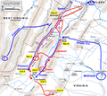
ファイル:Jackson Valley Campaign Part2.png
表示

このプレビューのサイズ: 673 × 599 ピクセル。 その他の解像度: 270 × 240 ピクセル | 539 × 480 ピクセル | 863 × 768 ピクセル | 1,150 × 1,024 ピクセル | 2,100 × 1,870 ピクセル。
元のファイル (2,100 × 1,870 ピクセル、ファイルサイズ: 1.6メガバイト、MIME タイプ: image/png)
ファイルの履歴
過去の版のファイルを表示するには、その版の日時をクリックしてください。
| 日付と時刻 | サムネイル | 寸法 | 利用者 | コメント | |
|---|---|---|---|---|---|
| 現在の版 | 2011年3月29日 (火) 00:54 |  | 2,100 × 1,870 (1.6メガバイト) | Hlj | Update to more recent graphical style. Improve accuracy of topography and troop positions. Add legend/scale. |
| 2009年7月24日 (金) 20:54 |  | 1,579 × 1,256 (423キロバイト) | Hlj | Updated troop movements, some labels. {{cc-by-3.0|Map by Hal Jespersen, www.posix.com/CW}} | |
| 2009年7月3日 (金) 22:39 |  | 1,579 × 1,256 (416キロバイト) | Hlj | {{Information |Description=Map of Jackson's Valley Campaign of the American Civil War. Added scale, state names, some cleanups to my previous version. Drawn in Adobe Illustrator CS3 by Hal Jespersen. Graphic source file is available at http://www.posi | |
| 2006年7月13日 (木) 15:12 |  | 1,525 × 1,196 (545キロバイト) | Cave cattum | {{Information| |Description= Map of Stonewall Jackson's Valley Campaign, Part 2 of 2 |Source= en:Image:Jackson Valley Campaign Part2.png: ''<nowiki>1525×1196 (557,640 bytes) (Map of Jackson's Valley Campaign of the American Civil War, part 2. Drawn |
ファイルの使用状況
以下の 5 ページがこのファイルを使用しています:
グローバルなファイル使用状況
以下に挙げる他のウィキがこの画像を使っています:
- azb.wikipedia.org での使用状況
- da.wikipedia.org での使用状況
- en-two.iwiki.icu での使用状況
- en.wikivoyage.org での使用状況
- fr.wikipedia.org での使用状況
- it.wikipedia.org での使用状況
- ko.wikipedia.org での使用状況
- nl.wikipedia.org での使用状況
- no.wikipedia.org での使用状況
- pl.wikipedia.org での使用状況
- www.wikidata.org での使用状況
