コンテンツにスキップ

英文维基 | 中文维基 | 日文维基 | 草榴社区

ファイル:LIRR 1891 Dunton station.jpg

ページのコンテンツが他言語でサポートされていません。

LIRR_1891_Dunton_station.jpg (376 × 293 ピクセル、ファイルサイズ: 43キロバイト、MIME タイプ: image/jpeg)

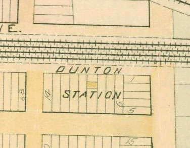
This is a portion of an 1891 map of Queens, New York, United States, showing Dunton station. The map was scanned by the New York Public Library with Digital Image ID 1523088. The north-south streets are Baker Avenue and Van Wyck Avenue, now 134th Street and the Van Wyck Expressway.

This is a crop of Image:LIRR 1891 Morris Park facility.jpg.

被写体の位置40° 41′ 51″ 北, 73° 48′ 57″ 西 Kartographer map based on OpenStreetMap.以下のサービスでこの位置を確認する: オープンストリートマップinfo
このファイルは、パブリックドメインの状態にある平面的な美術の著作物を写真術によって忠実に複製したものです。このような複製はアメリカ合衆国においてパブリックドメインの状態にあります。その他の地域では再利用に制限がかかる場合があります。詳しくはReuse of PD-Art photographsをご覧ください。美術の著作物としての原図は、次の理由によりパブリックドメインの状態にあります。
Public domain

この著作物は、著作権の保護期間が著作者の死後70年以下である国・地域においてパブリックドメインの状態にあります。


この著作物がアメリカ合衆国においてパブリックドメインの状態にあることを示すために、アメリカ合衆国のPDタグも貼る必要があります。
このファイルは著作権法の既知の制約(隣接権や関連する権利を含む)から自由であると特定されています。
{{PD-Art}} template without license parameter: please specify why the underlying work is public domain in both the source country and the United States
(Usage: {{PD-Art|1=|deathyear=''year of author's death''|country=''source country''}}, where parameter 1= can be PD-old-auto, PD-old-auto-expired, PD-old-auto-1996, PD-old-100 or similar. See Commons:Multi-license copyright tags for more information.)

キャプション

このファイルの内容を1行で記述してください

このファイルに描写されている項目

題材

40°41'51.000"N, 73°48'56.999"W

ファイルの履歴

過去の版のファイルを表示するには、その版の日時をクリックしてください。

日付と時刻サムネイル寸法利用者コメント
現在の版2007年2月13日 (火) 21:192007年2月13日 (火) 21:19時点における版のサムネイル376 × 293 (43キロバイト)NE2This is a portion of an 1891 map of Queens, New York, United States, showing Dunton station. The map was scanned by the New York Public Library with Digital Image ID 1523088. The north-south streets are Baker Avenue and Van Wyck Avenue, now 134th Street a

以下のページがこのファイルを使用しています:

グローバルなファイル使用状況

以下に挙げる他のウィキがこの画像を使っています:

メタデータ