
ファイル:MaineBoundaryDispute.jpg

このプレビューのサイズ: 424 × 599 ピクセル。 その他の解像度: 170 × 240 ピクセル | 340 × 480 ピクセル | 780 × 1,102 ピクセル。
元のファイル (780 × 1,102 ピクセル、ファイルサイズ: 306キロバイト、MIME タイプ: image/jpeg)
ウィキメディア・コモンズのファイルページにある説明を、以下に表示します。
|

|
このhistorical map画像は、ベクターイメージである SVG ファイルとして再作成されるべきです。これにはいくつかの利点があります。詳しくはCommons:Media for cleanupを参照してください。この画像の SVG 形式がすでに利用可能である場合は、アップロードしてください。アップロード後、この画像にあるこのテンプレートを{{Vector version available|新しい画像ファイル名.svg}}テンプレートで置き換えてください。
|


概要
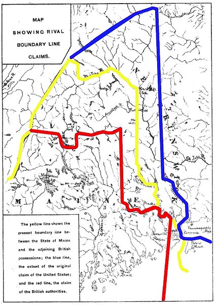
| 解説 | Map showing competing proposals for the boundary line between the US state of Maine and the British (now Canadian) province of New Brunswick. The red line marks the British proposal, the blue line marks the US proposal, and the yellow line marks the line agreed in the 1842 Webster-Ashburton Treaty, which resolved virtually all of the outstanding boundary issues in this area. |
| 日付 | Base map published 1888; annotations 2013 |
| 原典 | Annotations: own work |
| 作者 | User:Magicpiano |
ライセンス
| この著作物の著作権者である私は、この著作物における権利を放棄しパブリックドメインとします。これは全世界で適用されます。 一部の国では、これが法的に可能ではない場合があります。その場合は、次のように宣言します。 私は、あらゆる人に対して、法により必要とされている条件を除き、如何なる条件も課すことなく、あらゆる目的のためにこの著作物を使用する権利を与えます。 |
ファイルの履歴
過去の版のファイルを表示するには、その版の日時をクリックしてください。
| 日付と時刻 | サムネイル | 寸法 | 利用者 | コメント | |
|---|---|---|---|---|---|
| 現在の版 | 2013年3月15日 (金) 15:18 | | 780 × 1,102 (306キロバイト) | Magicpiano | swap red and blue to match inset text |
| 2013年2月18日 (月) 20:24 |  | 780 × 1,102 (306キロバイト) | Magicpiano | {{Information |Description=Map showing competing proposals for the boundary line between the US state of Maine and the British (now Canadian) province of New Brunswick. The blue line marks the British proposal, the red line marks the US proposal, and ... |
ファイルの使用状況
以下の 3 ページがこのファイルを使用しています:
グローバルなファイル使用状況
以下に挙げる他のウィキがこの画像を使っています:
- ar.wikipedia.org での使用状況
- ca.wikipedia.org での使用状況
- en-two.iwiki.icu での使用状況
- es.wikipedia.org での使用状況
- fi.wikipedia.org での使用状況
- he.wikipedia.org での使用状況
- pt.wikipedia.org での使用状況
- sv.wikipedia.org での使用状況
- www.wikidata.org での使用状況