
ファイル:Map of Williamsburg Virginia 1702 Franz Michel.jpg
高解像度版はありません。
Map_of_Williamsburg_Virginia_1702_Franz_Michel.jpg (432 × 272 ピクセル、ファイルサイズ: 46キロバイト、MIME タイプ: image/jpeg)
ウィキメディア・コモンズのファイルページにある説明を、以下に表示します。
|
概要
| 解説 |
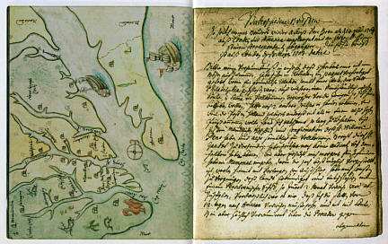
English: One of the earliest maps of Williamsburg (Middle Plantation), drawn by Franz Michel, a native of Switzerland who traveled to America. Michel's fanciful map shows ships, deer and a turkey, as well as Williamsburg "between the Jems and Jorgk Rivier, six miles from the Jems and ten from Jorgtown." On the page facing the map is a letter from Michel to his brother Hans. |
| 日付 | |
| 原典 | http://www.patc.us/history/native/michel2.html |
| 作者 | Franz Michel |
ライセンス
|
この著作物は、著作権の保護期間が著作者の死後100年以下である国・地域においてパブリックドメインの状態にあります。 | |
| このファイルは著作権法の既知の制約(隣接権や関連する権利を含む)から自由であると特定されています。 | |
ファイルの履歴
過去の版のファイルを表示するには、その版の日時をクリックしてください。
| 日付と時刻 | サムネイル | 寸法 | 利用者 | コメント | |
|---|---|---|---|---|---|
| 現在の版 | 2010年6月14日 (月) 12:39 | | 432 × 272 (46キロバイト) | MarmadukePercy | {{Information |Description={{en|1=One of the earliest maps of Williamsburg (Middle Plantation), drawn by Franz Michel, a native of Switzerland who traveled to America. Michel's fanciful map shows ships, deer and a turkey, as well as Williamsburg "between |
ファイルの使用状況
以下のページがこのファイルを使用しています:
グローバルなファイル使用状況
以下に挙げる他のウィキがこの画像を使っています:
- en-two.iwiki.icu での使用状況