
ファイル:Maricopa County Incorporated and Planning areas Goodyear highlighted.svg

この SVG ファイルのこの PNG プレビューのサイズ: 694 × 599 ピクセル. その他の解像度: 278 × 240 ピクセル | 556 × 480 ピクセル | 889 × 768 ピクセル | 1,185 × 1,024 ピクセル | 2,371 × 2,048 ピクセル | 940 × 812 ピクセル。
元のファイル (SVG ファイル、940 × 812 ピクセル、ファイルサイズ: 1.05メガバイト)
ウィキメディア・コモンズのファイルページにある説明を、以下に表示します。
|
概要
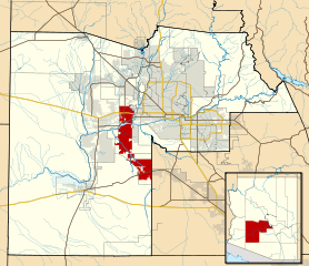
| 解説 | This map shows the incorporated areas and Indian reservation boundaries in Maricopa County, Arizona, along with water bodies and major highways and roads. Goodyear is highlighted in red. Other incorporated cities are shown in gray, planning area borders for these cities and Indian reservation borders are shown as solid black lines. Changes from Previous Version: Updated the maps to include water bodies and to make "less boring" than the plain black/white/gray maps. Format was updated to match standards laid out by WikiProject Maps/Conventions. Map data is based on data from the following Webpage: Maricopa County Interactive GIS Map. I created this map in Inkscape. |
| 日付 | |
| 原典 | My own work, based on government information |
| 作者 | Ixnayonthetimmay |
| 許可 (ファイルの再利用) |
Public Domain |
| その他のバージョン | See Category:Maps of Maricopa County for other versions of this image. |
ライセンス
| この著作物の著作権者である私は、この著作物における権利を放棄しパブリックドメインとします。これは全世界で適用されます。 一部の国では、これが法的に可能ではない場合があります。その場合は、次のように宣言します。 私は、あらゆる人に対して、法により必要とされている条件を除き、如何なる条件も課すことなく、あらゆる目的のためにこの著作物を使用する権利を与えます。 |
ファイルの履歴
過去の版のファイルを表示するには、その版の日時をクリックしてください。
| 日付と時刻 | サムネイル | 寸法 | 利用者 | コメント | |
|---|---|---|---|---|---|
| 現在の版 | 2011年5月20日 (金) 06:33 | | 940 × 812 (1.05メガバイト) | Ixnayonthetimmay | Uploading new version |
| 2008年8月30日 (土) 04:11 |  | 900 × 800 (413キロバイト) | Ixnayonthetimmay | == Summary == {{Information |Description=This map shows the incorporated areas and unincorporated areas in Maricopa County, Arizona. [[:en:Goodyear, Arizona| | |
| 2007年9月16日 (日) 00:15 |  | 900 × 800 (384キロバイト) | Ixnayonthetimmay | {{Information |Description= |Source= |Date= |Author= |Permission= |other_versions= }} | |
| 2007年5月28日 (月) 10:01 |  | 900 × 780 (329キロバイト) | Ixnayonthetimmay | ||
| 2007年5月22日 (火) 00:08 |  | 900 × 780 (318キロバイト) | Ixnayonthetimmay | ||
| 2007年1月30日 (火) 05:06 |  | 904 × 758 (189キロバイト) | Ixnayonthetimmay | {{Information |Description=This map shows the incorporated areas in Maricopa County, Arizona, highlighting Goodyear in red. It also shows the boundaries for the |
ファイルの使用状況
以下のページがこのファイルを使用しています:
グローバルなファイル使用状況
以下に挙げる他のウィキがこの画像を使っています:
- de.wikipedia.org での使用状況
- fa.wikipedia.org での使用状況
- fy.wikipedia.org での使用状況
- it.wikipedia.org での使用状況
- pt.wikipedia.org での使用状況
- sr.wikipedia.org での使用状況
- tr.wikipedia.org での使用状況
- ur.wikipedia.org での使用状況