
ファイル:Mawangdui Topographic Map.jpg
このプレビューのサイズ: 608 × 600 ピクセル。 その他の解像度: 243 × 240 ピクセル | 487 × 480 ピクセル | 779 × 768 ピクセル | 1,038 × 1,024 ピクセル | 2,076 × 2,048 ピクセル | 2,929 × 2,889 ピクセル。
元のファイル (2,929 × 2,889 ピクセル、ファイルサイズ: 2.37メガバイト、MIME タイプ: image/jpeg)
ウィキメディア・コモンズのファイルページにある説明を、以下に表示します。
|
概要
| 解説 |
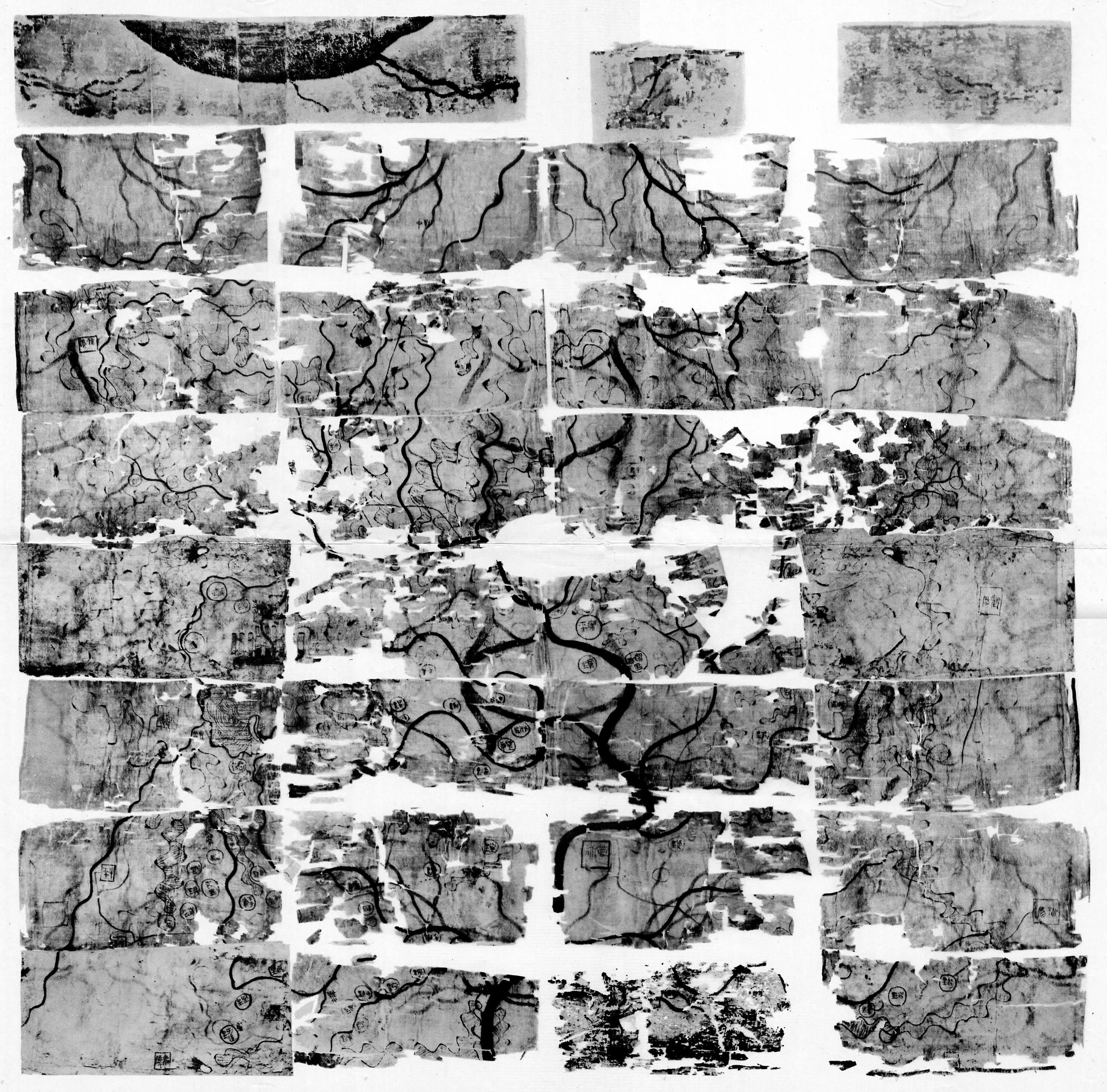
English: Silk map showing the topographic features of the area covered by the Han dynasty state of Changsha and the kingdom of Nanyue, corresponding to parts of the modern provinces of Hunan, Guangdong and Guangxi. Found in 1973 in Tomb 3 of the Mawangdui Western Han tomb complex. Datable to circa 168 BC. Map was folded five times into 32 sections which later disintegrated along the folds into thirty-two sheets. Dimensions: 96 × 96 cm. Scale: approximately 1:18,000. Oriented with south to the top. See also Mawangdui Military Map. 中文(繁體):馬王堆三號漢墓出土地形圖。 |
| 日付 | |
| 原典 | Scanned from 《古地图(马王堆汉墓帛书)》 [Guditu (Mawangdui Hanmu Boshu)] (Beijing: Wenwu Chubanshe, 1977) |
| 作者 | 不明 |
| その他のバージョン | Western Han Mawangdui Silk Map (colour image) |
ライセンス
この画像は、パブリックドメインにある原作品の機械的なスキャンか複写にすぎないこと、あるいは─入手可能な証拠から判断して─著作権保護が働かないような、機械的なスキャンまたは複写の結果と類似していることから、パブリックドメインにあります。原作品は下記の理由でパブリックドメインにあります。
使い方については、Commons:When to use the PD-scan tagをご覧ください。 注意:このタグはスキャンと複写にのみ適用されます。パブリックドメインの現物を一定の距離から写真撮影したものの場合は、{{PD-Art}}が適用できるかもしれません。詳しくはCommons:When to use the PD-scan tagをご覧ください。 | ||||
ファイルの履歴
過去の版のファイルを表示するには、その版の日時をクリックしてください。
| 日付と時刻 | サムネイル | 寸法 | 利用者 | コメント | |
|---|---|---|---|---|---|
| 現在の版 | 2012年12月31日 (月) 01:45 | | 2,929 × 2,889 (2.37メガバイト) | BabelStone | User created page with UploadWizard |
ファイルの使用状況
以下のページがこのファイルを使用しています:
グローバルなファイル使用状況
以下に挙げる他のウィキがこの画像を使っています:
- en-two.iwiki.icu での使用状況