
ファイル:Mdwild31c.JPG

このプレビューのサイズ: 391 × 600 ピクセル。 その他の解像度: 156 × 240 ピクセル | 313 × 480 ピクセル | 705 × 1,081 ピクセル。
元のファイル (705 × 1,081 ピクセル、ファイルサイズ: 161キロバイト、MIME タイプ: image/jpeg)
ウィキメディア・コモンズのファイルページにある説明を、以下に表示します。
|
概要
| 解説 |
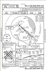
English: ILS or LOC/DME RWY 31C approach chart. Prepared by the National Aeronautical Charting Office for the Federal Aviation Administration. Minimums listed in lower right indicate with an operating Instrument Landing System a pilot can safely descend to 863' above sea level or 250' above ground level with a runway visual range of 4,000'. No longer valid for navigation. |
| 原典 | |
| 作者 | Skywayman at en.wikipedia |
ライセンス
This image or file is a work of a Federal Aviation Administration employee, taken or made as part of that person's official duties. As a work of the U.S. federal government, the image is in the public domain in the United States.
|
 |
元のアップロードログ
元のファイルページはこちら。以下の利用者は全てen.wikipediaに属します。
Upload date | User | Bytes | Dimensions | Comment
- 2005-12-16 04:07 (UTC) | Skywayman | 164486 (bytes) | 705×1081 | ILS or LOC/DME RWY 31C approach chart. Prepared by the National Aeronautical Charting Office for the Federal Aviation Administration
ファイルの履歴
過去の版のファイルを表示するには、その版の日時をクリックしてください。
| 日付と時刻 | サムネイル | 寸法 | 利用者 | コメント | |
|---|---|---|---|---|---|
| 現在の版 | 2011年9月18日 (日) 07:03 | | 705 × 1,081 (161キロバイト) | SreeBot | (Original text) : ILS or LOC/DME RWY 31C approach chart. Prepared by the National Aeronautical Charting Office for the Federal Aviation Administration |
ファイルの使用状況
以下のページがこのファイルを使用しています:
グローバルなファイル使用状況
以下に挙げる他のウィキがこの画像を使っています:
- en-two.iwiki.icu での使用状況
- he.wikipedia.org での使用状況
- it.wikipedia.org での使用状況
- pl.wikipedia.org での使用状況
- pt.wikipedia.org での使用状況