
ファイル:NetherlandsNewGuinea-1916.jpg

元のファイル (3,000 × 1,895 ピクセル、ファイルサイズ: 6.3メガバイト、MIME タイプ: image/jpeg)
ウィキメディア・コモンズのファイルページにある説明を、以下に表示します。
|
概要

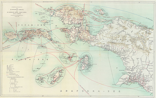
Steamboat connections in Netherlands New Guinea (1915)
This map, published in 1915, is an overview of steamboat connections in the Western New Guinea region. The image was published in Batavia (now Jakarta, Indonesia) in what was then known as the Dutch East Indies. The map is published by a company called G. Kolff & Co and uploaded by PapuaWeb.org アーカイブされたコピー at the Wayback Machine on the Maps of Papua アーカイブされたコピー at the Wayback Machine page. As per the Netherlands Copyright Act of 1912 アーカイブされたコピー at the Wayback Machine, which applies to works published in the Dutch East Indies (Article 47a), the copyright has expired on 1 January 1986 because only the publishing company, not the author, is known (Article 38).
From en:Image:NetherlandsNewGuinea-1916.jpg by en:User:Arsonal
ライセンス
|
この著作物は、著作権の保護期間が著作者の死後70年以下である国・地域においてパブリックドメインの状態にあります。
| |
| このファイルは著作権法の既知の制約(隣接権や関連する権利を含む)から自由であると特定されています。 | |
ファイルの履歴
過去の版のファイルを表示するには、その版の日時をクリックしてください。
| 日付と時刻 | サムネイル | 寸法 | 利用者 | コメント | |
|---|---|---|---|---|---|
| 現在の版 | 2006年7月6日 (木) 21:52 | | 3,000 × 1,895 (6.3メガバイト) | Hardscarf | == Summary == === Military Expeditions to Nederlands Nieuw-Guinea 1907-1915 === This map published in 1916 is a documentation of Dutch military expeditions to the Western New Guinea region. The image was published in Batavia (now Jakarta, Indonesia) in |
ファイルの使用状況
以下のページがこのファイルを使用しています:
グローバルなファイル使用状況
以下に挙げる他のウィキがこの画像を使っています:
- ar.wikipedia.org での使用状況
- arz.wikipedia.org での使用状況
- ban.wikipedia.org での使用状況
- ca.wikipedia.org での使用状況
- cs.wikipedia.org での使用状況
- de.wikipedia.org での使用状況
- en-two.iwiki.icu での使用状況
- eo.wikipedia.org での使用状況
- es.wikipedia.org での使用状況
- fr.wikipedia.org での使用状況
- id.wikipedia.org での使用状況
- it.wikipedia.org での使用状況
- ko.wikipedia.org での使用状況
- nl.wikipedia.org での使用状況
- pam.wikipedia.org での使用状況
- pl.wikipedia.org での使用状況
- pt.wikipedia.org での使用状況
- ru.wikipedia.org での使用状況
- sq.wikipedia.org での使用状況
- sv.wikipedia.org での使用状況
- tr.wikipedia.org での使用状況
- www.wikidata.org での使用状況
- zea.wikipedia.org での使用状況
- zh-two.iwiki.icu での使用状況