
ファイル:Northern Mali conflict.svg

この SVG ファイルのこの PNG プレビューのサイズ: 629 × 600 ピクセル. その他の解像度: 252 × 240 ピクセル | 503 × 480 ピクセル | 805 × 768 ピクセル | 1,074 × 1,024 ピクセル | 2,148 × 2,048 ピクセル | 1,316 × 1,255 ピクセル。
元のファイル (SVG ファイル、1,316 × 1,255 ピクセル、ファイルサイズ: 796キロバイト)
ウィキメディア・コモンズのファイルページにある説明を、以下に表示します。
|
概要
| 解説 |
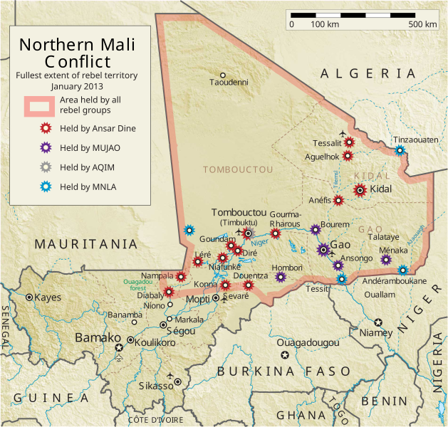
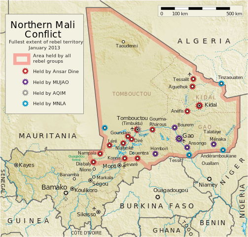
English: Map of the conflict in Northern Mali. (English)
العربية: خريطة الصّراع في شمال مالي. (إنجليزي)
Français : Carte du conflit au nord du Mali. (Anglais)
Latina: Charta rebellionis Tuaregorum in Malia septentrionali. (Anglice)
Українська: Карта конфлікту на півночі Малі. (Англійською) |
| 原典 |
投稿者自身による著作物 |
| 作者 | Orionist |
| その他のバージョン | German/Deutsch/Allemand, French/Français, Macedonian/македонски јазик/Macédonien |
| SVG 開発 | このW3C-無効 ベクター画像はAdobe Illustratorで作成されました, and with Inkscape. このSVG地図は埋込み文を用いており,テキストエディタを用いて容易に翻訳することができますいます。 |
Notes
- ↑ US Department of State, "Country Reports on Terrorism 2011", Chapter 2 Country Reports: Africa Overview, 31 July 2012
ライセンス
この作品の著作権者である私は、この作品を以下のライセンスで提供します。
このファイルはクリエイティブ・コモンズ 表示-継承 3.0 非移植ライセンスのもとに利用を許諾されています。
- あなたは以下の条件に従う場合に限り、自由に
- 共有 – 本作品を複製、頒布、展示、実演できます。
- 再構成 – 二次的著作物を作成できます。
- あなたの従うべき条件は以下の通りです。
- 表示 – あなたは適切なクレジットを表示し、ライセンスへのリンクを提供し、変更があったらその旨を示さなければなりません。これらは合理的であればどのような方法で行っても構いませんが、許諾者があなたやあなたの利用行為を支持していると示唆するような方法は除きます。
- 継承 – もしあなたがこの作品をリミックスしたり、改変したり、加工した場合には、あなたはあなたの貢献部分を元の作品とこれと同一または互換性があるライセンスの下に頒布しなければなりません。
ファイルの履歴
過去の版のファイルを表示するには、その版の日時をクリックしてください。
| 日付と時刻 | サムネイル | 寸法 | 利用者 | コメント | |
|---|---|---|---|---|---|
| 現在の版 | 2014年4月8日 (火) 06:59 | | 1,316 × 1,255 (796キロバイト) | Ansh666 | Reverted to version as of 16:51, 8 March 2013 - restoring the correct version, as the map is supposed to be historical, not current |
| 2013年12月5日 (木) 20:15 |  | 1,316 × 1,255 (699キロバイト) | Hanibal911 | more accurately reflects the situation | |
| 2013年3月8日 (金) 16:51 |  | 1,316 × 1,255 (796キロバイト) | Agricolae | Hombori dot restored | |
| 2013年3月5日 (火) 14:29 |  | 1,316 × 1,255 (794キロバイト) | TUFKAAP | Since this is an English map, Al-Qaeda in the Islamic Maghreb should be abbreviated as AQIM. | |
| 2013年2月11日 (月) 03:33 |  | 1,316 × 1,255 (794キロバイト) | Agricolae | shift text distorted on upload | |
| 2013年2月11日 (月) 03:27 |  | 1,316 × 1,255 (794キロバイト) | Agricolae | change to show greatest extent - see WP Talk:Northern Mali conflict (2012–present) | |
| 2013年2月8日 (金) 06:36 |  | 1,316 × 1,255 (699キロバイト) | Rama | Aguelhok contested or taken ( http://www.lemonde.fr/afrique/article/2013/02/08/mali-les-forces-francaise-et-tchadiennes-a-aguelhok_1828906_3212.html ) | |
| 2013年2月2日 (土) 10:29 |  | 1,316 × 1,255 (698キロバイト) | U5K0 | Bourem to green as per talk page | |
| 2013年1月30日 (水) 08:41 |  | 1,316 × 1,255 (679キロバイト) | Orionist | Updated map: Menaka, Anderamboukane, Ansongo, Dire, Kidal and other MNLA positions. Removed rebel area boundaries as the situation has become complicated. | |
| 2013年1月29日 (火) 17:23 |  | 1,316 × 1,255 (894キロバイト) | Jaybear | Insertion of a map-scale in the upper right corner (added directly before the token "/svg" at end of svg-code); |
ファイルの使用状況
以下の 2 ページがこのファイルを使用しています:
グローバルなファイル使用状況
以下に挙げる他のウィキがこの画像を使っています:
- af.wikipedia.org での使用状況
- ar.wikipedia.org での使用状況
- azb.wikipedia.org での使用状況
- az.wikipedia.org での使用状況
- bg.wikipedia.org での使用状況
- bn.wikipedia.org での使用状況
- ca.wikipedia.org での使用状況
- cs.wikipedia.org での使用状況
- cy.wikipedia.org での使用状況
- da.wikipedia.org での使用状況
- de.wikipedia.org での使用状況
- el.wikipedia.org での使用状況
- en-two.iwiki.icu での使用状況
- Mali
- Portal:Mali
- Insurgency in the Maghreb (2002–present)
- War on terror
- User:Orionist/Gallery
- National Movement for the Liberation of Azawad
- Wikipedia talk:WikiProject Maps/Archive 2012
- Wikipedia:In the news/Candidates/April 2012
- Wikipedia:Graphics Lab/Map workshop/Archive/Apr 2012
- Wikipedia:Wikipedia Signpost/2012-04-30/WikiProject report
- Wikipedia:Wikipedia Signpost/Single/2012-04-30
- Mali War
- Wikipedia:WikiProject Maps/Conventions/Pushpin maps
- Operation Serval
- Chadian intervention in northern Mali
- Islamist insurgency in the Sahel
- User:AlbanianEditor1990/sandbox
- en.wikinews.org での使用状況
- eo.wikipedia.org での使用状況
- es.wikipedia.org での使用状況
- et.wikipedia.org での使用状況
- eu.wikipedia.org での使用状況
- fi.wikipedia.org での使用状況
このファイルのグローバル使用状況を表示する。