
ファイル:Odoacer 480ad.jpg

元のファイル (900 × 545 ピクセル、ファイルサイズ: 701キロバイト、MIME タイプ: image/jpeg)
ウィキメディア・コモンズのファイルページにある説明を、以下に表示します。
|

|
このhistorical map画像は、ベクターイメージである SVG ファイルとして再作成されるべきです。これにはいくつかの利点があります。詳しくはCommons:Media for cleanupを参照してください。この画像の SVG 形式がすでに利用可能である場合は、アップロードしてください。アップロード後、この画像にあるこのテンプレートを{{Vector version available|新しい画像ファイル名.svg}}テンプレートで置き換えてください。
|


概要
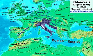
| 解説 | Odoacer's Kingdom of Italy in 480 AD. |
| 日付 | |
| 原典 | 投稿者自身による著作物 |
| 作者 | Thomas Lessman (Contact!) |
| 許可 (ファイルの再利用) |
この作品の著作権者である私は、この作品を以下のライセンスで提供します。 このファイルはクリエイティブ・コモンズ 表示-継承 3.0 非移植ライセンスのもとに利用を許諾されています。
|
| その他のバージョン | See Below |
Map Summary
Original Source URL: http://www.thomaslessman.com/History/images/East-Hem_480ad.jpg or www.WorldHistoryMaps.info
This map of the Kingdom of Odoacer in 480 AD is a zoomed-in version of Thomas Lessman's map of the East-Hem 480 AD, also available at www.WorldHistoryMaps.info.
The highlighted areas represent Odoacer's Kingdom of Italy, after the capture of Italy (476), conquest of Sicily from the Vandals (477) and the annexation of Dalmatia after the assassination of Emperor Julius Nepos (480).
Map Source References
Remember, sources often conflict with each other. This map is only as accurate as the information that is available to me. To report any errors or to help further this work, please click here, or email Thomas Lessman at [email protected]
References for information contained in this map:
Other Maps by Thomas Lessman
| Maps of the eastern hemisphere showing history
Bold dates are available on Wikimedia or Wikipedia. | ||
| Primeval | ||
| Ancient
|
·| 600 BC | 550 BC | 527 BC | 500 BC |
400 BC | ·| 1 AD | 50 AD | 100 AD | 200 AD | 300 AD | | |
| Medieval |
·| 500 AD | 565 AD | 600 AD | 700 AD | | |
| Modern |
·| 1500 AD | · * For historical maps of the whole world, | |
ファイルの履歴
過去の版のファイルを表示するには、その版の日時をクリックしてください。
| 日付と時刻 | サムネイル | 寸法 | 利用者 | コメント | |
|---|---|---|---|---|---|
| 現在の版 | 2022年10月23日 (日) 19:50 | | 900 × 545 (701キロバイト) | Gyalu22 | Reverted bad faith edit. The Westermanns Atlas doesn't show the Carpi |
| 2015年9月15日 (火) 16:05 |  | 900 × 545 (727キロバイト) | Spiridon Ion Cepleanu | Details about the low-Danube according with H.E.Stier's (dir.) Grosser Atlas zur Weltgeschichte, Westermann 1985. | |
| 2008年10月2日 (木) 21:40 |  | 900 × 545 (701キロバイト) | Talessman | {{Information |Description= |Source= |Date= |Author= |Permission= |other_versions= }} | |
| 2008年5月10日 (土) 10:29 |  | 1,402 × 1,023 (380キロバイト) | Talessman | {{Information |Description=<big>'''The Odoacer's Kingdom of Italy in 477 AD.'''</big> |Source=Self-made |Author=Thomas Lessman |Permission={{self|cc-by-sa-3.0}} }} |
ファイルの使用状況
グローバルなファイル使用状況
以下に挙げる他のウィキがこの画像を使っています:
- azb.wikipedia.org での使用状況
- ba.wikipedia.org での使用状況
- bg.wikipedia.org での使用状況
- br.wikipedia.org での使用状況
- ca.wikipedia.org での使用状況
- de.wikipedia.org での使用状況
- el.wikipedia.org での使用状況
- en-two.iwiki.icu での使用状況
- es.wikipedia.org での使用状況
- eu.wikipedia.org での使用状況
- fi.wikipedia.org での使用状況
- fr.wikipedia.org での使用状況
- fy.wikipedia.org での使用状況
- hy.wikipedia.org での使用状況
- ia.wikipedia.org での使用状況
- it.wikipedia.org での使用状況
- ko.wikipedia.org での使用状況
- li.wikipedia.org での使用状況
- lmo.wikipedia.org での使用状況
- lt.wikipedia.org での使用状況
- lv.wikipedia.org での使用状況
- nds.wikipedia.org での使用状況
- nl.wikipedia.org での使用状況
- pl.wikipedia.org での使用状況
このファイルのグローバル使用状況を表示する。