
ファイル:Offa Kent map.gif
高解像度版はありません。
Offa_Kent_map.gif (552 × 390 ピクセル、ファイルサイズ: 69キロバイト、MIME タイプ: image/gif)
ウィキメディア・コモンズのファイルページにある説明を、以下に表示します。
|
| 解説 |
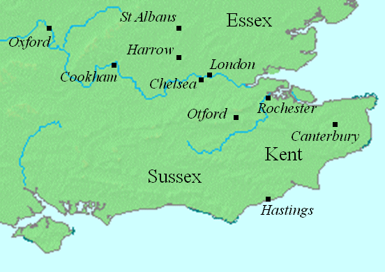
English: This map shows locations in southeastern England relevant to the article on Offa of Mercia.
This file was created using DMIS. On that site it is stated that "We do not claim copyright on the images, so you can use them for Wikipedia." |
||
| 日付 | Uploaded to the English language Wikipedia in January 2008 (log) | ||
| 原典 | en:Image:Offa Kent map.gif | ||
| 作者 | Mike Christie (talk) | ||
| 許可 (ファイルの再利用) |
|
ファイルの履歴
過去の版のファイルを表示するには、その版の日時をクリックしてください。
| 日付と時刻 | サムネイル | 寸法 | 利用者 | コメント | |
|---|---|---|---|---|---|
| 現在の版 | 2008年8月12日 (火) 22:19 | | 552 × 390 (69キロバイト) | Elinnea | {{Information |Description=This map shows locations in southeastern England relevant to the article on Offa of Mercia. This file was created using [http://www.demis.nl/home/pages/home.htm DMIS]. On that site it is [http://support.demis.nl/forums/thr |
ファイルの使用状況
以下のページがこのファイルを使用しています:
グローバルなファイル使用状況
以下に挙げる他のウィキがこの画像を使っています:
- arz.wikipedia.org での使用状況
- azb.wikipedia.org での使用状況
- ca.wikipedia.org での使用状況
- el.wikipedia.org での使用状況
- en-two.iwiki.icu での使用状況
- fa.wikipedia.org での使用状況
- id.wikipedia.org での使用状況
- nl.wikipedia.org での使用状況
- sv.wikipedia.org での使用状況