
ファイル:Ohridski-Map.PNG

このプレビューのサイズ: 475 × 600 ピクセル。 その他の解像度: 190 × 240 ピクセル | 380 × 480 ピクセル | 608 × 768 ピクセル | 811 × 1,024 ピクセル | 1,622 × 2,048 ピクセル | 2,849 × 3,598 ピクセル。
元のファイル (2,849 × 3,598 ピクセル、ファイルサイズ: 29.38メガバイト、MIME タイプ: image/png)
ウィキメディア・コモンズのファイルページにある説明を、以下に表示します。
|
概要
| 解説 |
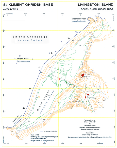
English: L.L. Ivanov, St. Kliment Ohridski Base, Livingston Island, 1:1 000 scale topographic map, Commissioned by the Antarctic Place-names Commission of Bulgaria, sponsored by the Atlantic Club of Bulgaria and the Bulgarian Antarctic Institute, Sofia, 1996. The first Bulgarian Antarctic topographic map.
Note: 'New building' actually refers to the foundations of the new main building of the Bulgarian Base as of 1996; the building itself was completed in 1998. |
| 日付 | |
| 原典 | 投稿者自身による著作物 |
| 作者 | User:Apcbg |
| その他のバージョン | File:Ohridski-Map.jpg |
| カメラの位置 | | 以下のサービスでこの位置を確認する: オープンストリートマップ |
|---|
ライセンス
この作品の著作権者である私は、この作品を以下のライセンスで提供します。
このファイルはクリエイティブ・コモンズ 表示-継承 4.0 国際ライセンスのもとに利用を許諾されています。
- あなたは以下の条件に従う場合に限り、自由に
- 共有 – 本作品を複製、頒布、展示、実演できます。
- 再構成 – 二次的著作物を作成できます。
- あなたの従うべき条件は以下の通りです。
- 表示 – あなたは適切なクレジットを表示し、ライセンスへのリンクを提供し、変更があったらその旨を示さなければなりません。これらは合理的であればどのような方法で行っても構いませんが、許諾者があなたやあなたの利用行為を支持していると示唆するような方法は除きます。
- 継承 – もしあなたがこの作品をリミックスしたり、改変したり、加工した場合には、あなたはあなたの貢献部分を元の作品とこれと同一または互換性があるライセンスの下に頒布しなければなりません。
ファイルの履歴
過去の版のファイルを表示するには、その版の日時をクリックしてください。
| 日付と時刻 | サムネイル | 寸法 | 利用者 | コメント | |
|---|---|---|---|---|---|
| 現在の版 | 2010年7月27日 (火) 08:25 | | 2,849 × 3,598 (29.38メガバイト) | Apcbg | Decreased size to less than 12.5 million pixels. |
| 2010年7月27日 (火) 08:14 |  | 3,561 × 4,497 (3.52メガバイト) | Apcbg | A redrawn version of the map. | |
| 2009年5月23日 (土) 08:58 |  | 2,762 × 3,317 (1.26メガバイト) | Apcbg | {{Information |Description={{en|1=L.L. Ivanov, St. Kliment Ohridski Base, Livingston Island, 1:1 000 scale topographic map, Commissioned by the Antarctic Place-names Commission of Bulgaria, sponsored by the Atlantic Club of Bulgaria and the Bulgarian Anta |
ファイルの使用状況
以下のページがこのファイルを使用しています:
グローバルなファイル使用状況
以下に挙げる他のウィキがこの画像を使っています:
- bg.wikipedia.org での使用状況
- ca.wikipedia.org での使用状況
- en-two.iwiki.icu での使用状況
- es.wikipedia.org での使用状況
- fr.wikipedia.org での使用状況
- it.wikipedia.org での使用状況
- mk.wikipedia.org での使用状況
- nn.wikipedia.org での使用状況
- pt.wikipedia.org での使用状況