
ファイル:PhiladelCampaignHessianMap.jpg

元のファイル (1,510 × 1,282 ピクセル、ファイルサイズ: 274キロバイト、MIME タイプ: image/jpeg)
ウィキメディア・コモンズのファイルページにある説明を、以下に表示します。
|
概要
| 解説 |
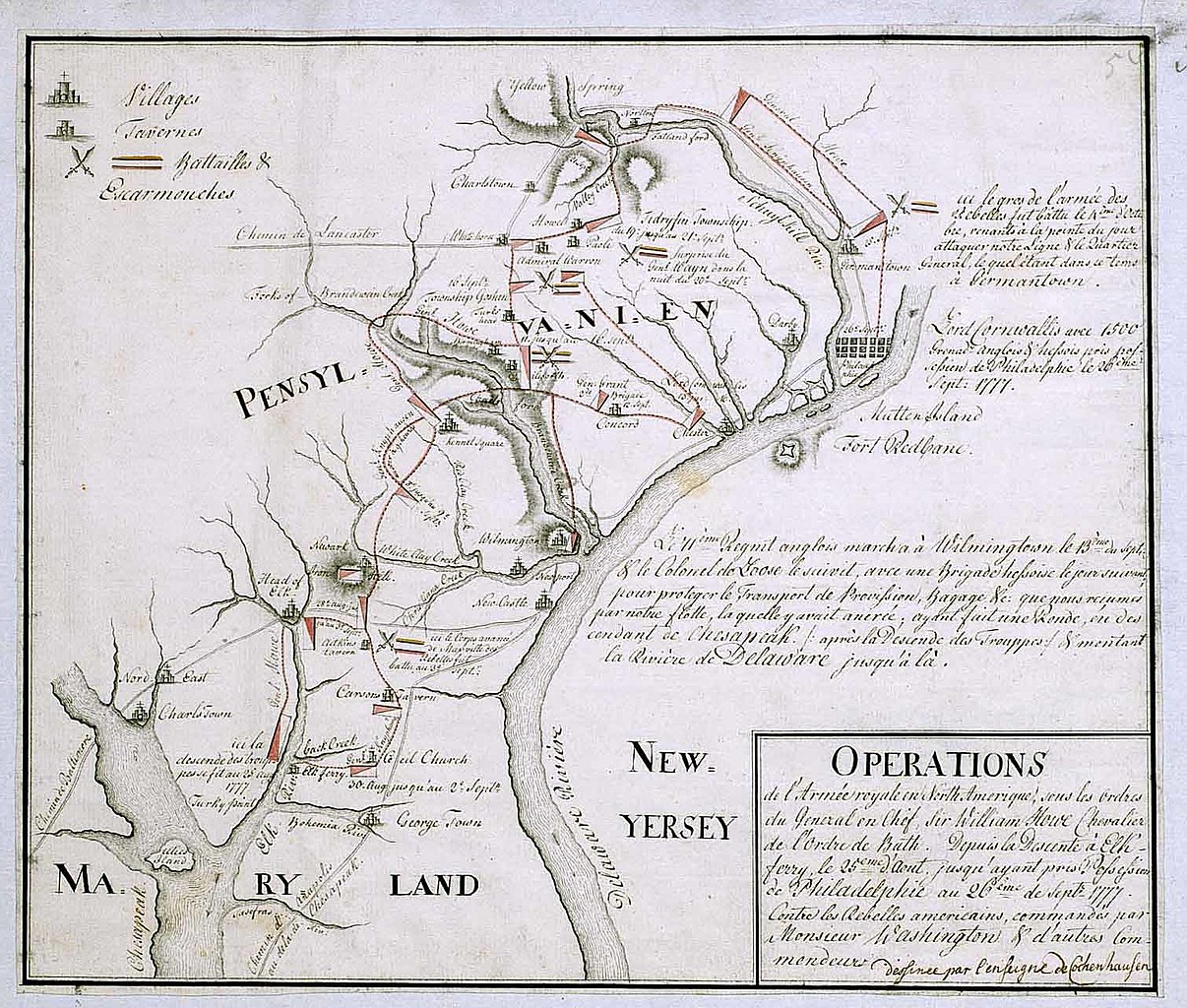
English: 18th century Hessian map from the Marburg State Library in Germany
of the Philadelphia Campaign (Battle of Brandywine, Forts Mercer and Redbank, Germantown, etc.) via the website of the West Jersey History Project http://westjerseyhistory.org/maps/revwarmaps/hessianmaps/index6.shtml Text in French, accompanying maps dated either 1777 or 1787 Quick translation"Operations of the royal army in North America under the orders of Sir William Howe, Knight of the Order of Bath. From the descent at Elk Ferry 25 August until taking possession of Philadelphia 26 September, 1777 against the american Rebels commandeed by Mr. Washington and other commanders. (Map) Designed by Ensign Cochenhausen" |
| 原典 | |
| 作者 |
ライセンス
|
このファイルは、パブリックドメインの状態にある平面的な美術の著作物を写真術によって忠実に複製したものです。このような複製はアメリカ合衆国においてパブリックドメインの状態にあります。その他の地域では再利用に制限がかかる場合があります。詳しくはReuse of PD-Art photographsをご覧ください。美術の著作物としての原図は、次の理由によりパブリックドメインの状態にあります。
{{PD-Art}} template without license parameter: please specify why the underlying work is public domain in both the source country and the United States
(Usage: {{PD-Art|1=|deathyear=''year of author's death''|country=''source country''}}, where parameter 1= can be PD-old-auto, PD-old-auto-expired, PD-old-auto-1996, PD-old-100 or similar. See Commons:Multi-license copyright tags for more information.) | ||||
元のアップロードログ
- 2008-01-12 16:39 Smallbones 1510×1282×??? (280724 bytes) 18th century Hessian map from the Marburg State Library in Germany of the Philadelphia Campaign (Battle of Brandywine, Forts Mercer and Redbank, Germantown, etc.) via the website of the West Jersey History Project http://westjerseyhistory.org/maps/revwarm
ファイルの履歴
過去の版のファイルを表示するには、その版の日時をクリックしてください。
| 日付と時刻 | サムネイル | 寸法 | 利用者 | コメント | |
|---|---|---|---|---|---|
| 現在の版 | 2008年8月20日 (水) 21:23 | | 1,510 × 1,282 (274キロバイト) | File Upload Bot (Magnus Manske) | {{BotMoveToCommons|en.wikipedia}} {{Information |Description={{en|18th century Hessian map from the Marburg State Library in Germany of the Philadelphia Campaign (Battle of Brandywine, Forts Mercer and Redbank, Germantown, etc.) via the website of the We |
ファイルの使用状況
以下の 2 ページがこのファイルを使用しています:
グローバルなファイル使用状況
以下に挙げる他のウィキがこの画像を使っています:
- azb.wikipedia.org での使用状況
- ca.wikipedia.org での使用状況
- cs.wikipedia.org での使用状況
- da.wikipedia.org での使用状況
- en-two.iwiki.icu での使用状況
- es.wikipedia.org での使用状況
- fa.wikipedia.org での使用状況
- fi.wikipedia.org での使用状況
- fr.wikipedia.org での使用状況
- gl.wikipedia.org での使用状況
- it.wikipedia.org での使用状況
- ko.wikipedia.org での使用状況
- pl.wikipedia.org での使用状況
- pt.wikipedia.org での使用状況
- ro.wikipedia.org での使用状況
- ru.wikipedia.org での使用状況
- zh-two.iwiki.icu での使用状況