
ファイル:Phoenix Grand Prix Route - 1991.svg

この SVG ファイルのこの PNG プレビューのサイズ: 800 × 336 ピクセル. その他の解像度: 320 × 134 ピクセル | 640 × 269 ピクセル | 1,024 × 430 ピクセル | 1,280 × 538 ピクセル | 2,560 × 1,076 ピクセル | 1,818 × 764 ピクセル。
元のファイル (SVG ファイル、1,818 × 764 ピクセル、ファイルサイズ: 334キロバイト)
ウィキメディア・コモンズのファイルページにある説明を、以下に表示します。
|
概要
| 解説 |
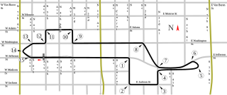
English: Track map for Phoenix street circuit. This version applies only to 1991. The track changed that year. For the version of the track as of 1989-1990, please see Image:Phoenix Grand Prix Route - 1989, 1990.svg (below). |
| 日付 | |
| 原典 | 投稿者自身による著作物 |
| 作者 | Will Pittenger |
| その他のバージョン |
|


| カメラの位置 | | 以下のサービスでこの位置を確認する: オープンストリートマップ |
|---|
ライセンス
| この著作物の著作権者である私は、この著作物における権利を放棄しパブリックドメインとします。これは全世界で適用されます。 一部の国では、これが法的に可能ではない場合があります。その場合は、次のように宣言します。 私は、あらゆる人に対して、法により必要とされている条件を除き、如何なる条件も課すことなく、あらゆる目的のためにこの著作物を使用する権利を与えます。 |
ファイルの履歴
過去の版のファイルを表示するには、その版の日時をクリックしてください。
| 日付と時刻 | サムネイル | 寸法 | 利用者 | コメント | |
|---|---|---|---|---|---|
| 現在の版 | 2008年7月25日 (金) 08:50 | | 1,818 × 764 (334キロバイト) | Will Pittenger | MediaWiki/RSVG and Firefox 3.0 were both showing the vertical text horizontally. This version fixes that by converting such text objects into paths. Important: If you need to edit this SVG, please use the previous version. |
| 2008年7月25日 (金) 08:24 | 1,965 × 795 (160キロバイト) | Will Pittenger | {{Information |Description={{en|1=Track map for w:Phoenix street circuit. This version applies only to w:1991. The track changed that year. For the version of the track as of w:1989-w:1990, please see [[:Image:Phoenix Grand Prix Rou |
ファイルの使用状況
以下の 3 ページがこのファイルを使用しています:
グローバルなファイル使用状況
以下に挙げる他のウィキがこの画像を使っています:
- af.wikipedia.org での使用状況
- ar.wikipedia.org での使用状況
- ast.wikipedia.org での使用状況
- bg.wikipedia.org での使用状況
- bn.wikipedia.org での使用状況
- br.wikipedia.org での使用状況
- bs.wikipedia.org での使用状況
- cs.wikipedia.org での使用状況
- de.wikipedia.org での使用状況
- en-two.iwiki.icu での使用状況
- United States Grand Prix
- List of Formula One circuits
- 1991 United States Grand Prix
- Phoenix street circuit
- User talk:Chubbennaitor/archive2
- User talk:Barkjon/Archive 2
- Wikipedia:WikiProject Formula One/Newsletter/200808
- User talk:Hellboy2hell/archive2
- User talk:NapHit/Archive 1
- User talk:4u1e/archive5
- User talk:Typ932/Archive 3
- User talk:Midgrid/Archive 6
- User talk:Thelb4/Archive 5
- User talk:Chubbennaitor/Archive7
- User talk:Readro/Archive 3
- User talk:Donnie Park/Archive 1
- User talk:The359/Archive 4
- User talk:Cs-wolves/Archive 3
- User talk:Bam123456789/Archive 1
- User talk:Sage Callahan/Archive 1
- User talk:Cdhaptomos/Archive 1
- User talk:Spenalzo/Archive/2008
- User talk:Clyde1998/Archive/2008
- es.wikipedia.org での使用状況
- et.wikipedia.org での使用状況
- eu.wikipedia.org での使用状況
- fa.wikipedia.org での使用状況
- fi.wikipedia.org での使用状況
- fr.wikipedia.org での使用状況
- fy.wikipedia.org での使用状況
このファイルのグローバル使用状況を表示する。