
ファイル:Pinal County Arizona Incorporated and Unincorporated areas.svg

この SVG ファイルのこの PNG プレビューのサイズ: 800 × 600 ピクセル. その他の解像度: 320 × 240 ピクセル | 640 × 480 ピクセル | 1,024 × 768 ピクセル | 1,280 × 960 ピクセル | 2,560 × 1,920 ピクセル。
元のファイル (SVG ファイル、800 × 600 ピクセル、ファイルサイズ: 152キロバイト)
ウィキメディア・コモンズのファイルページにある説明を、以下に表示します。
|
概要
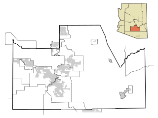
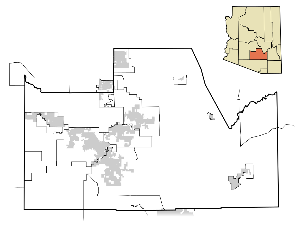
| 解説 | This map shows the incorporated areas and unincorporated areas in Pinal County, Arizona. Other incorporated cities are shown in gray, planning area borders for these cities and Indian reservation borders are shown as solid black lines. Map data is based on the following files as noted, all of which are .pdf files: *Pinal County 2008 Comprehensive Plan Amendments (.pdf) - For determining incorporated and Indian reservation boundaries. *CAAG Pinal Planning Commissioners Presentation (.pdf) - For determining planning area boundaries in Pinal County. *CAAG Population Estimates for Pinal County Places (.pdf) - For determining boundaries of unincorporated areas in Pinal County. Additional data for cities shown are based on individual files from each city's Website. (Please view the category page for links to these files.) I created this map in Inkscape. Please Note: This file replaces Image:Pinal County Incorporated areas.svg, which is now obsolete! |
| 日付 | |
| 原典 | My own work, based on public domain information |
| 作者 | Ixnayonthetimmay |
| 許可 (ファイルの再利用) |
Public Domain |
| その他のバージョン | See Category:Maps of Pinal County for other versions of this image. |
== ライセンス ==
| この著作物の著作権者である私は、この著作物における権利を放棄しパブリックドメインとします。これは全世界で適用されます。 一部の国では、これが法的に可能ではない場合があります。その場合は、次のように宣言します。 私は、あらゆる人に対して、法により必要とされている条件を除き、如何なる条件も課すことなく、あらゆる目的のためにこの著作物を使用する権利を与えます。 |
ファイルの履歴
過去の版のファイルを表示するには、その版の日時をクリックしてください。
| 日付と時刻 | サムネイル | 寸法 | 利用者 | コメント | |
|---|---|---|---|---|---|
| 現在の版 | 2009年7月8日 (水) 05:51 | | 800 × 600 (152キロバイト) | Ixnayonthetimmay | == Summary == {{Information |Description=This map shows the incorporated areas and unincorporated areas in Pinal County, Arizona. [[:en:Top-of-the-World, Arizon |
| 2008年4月19日 (土) 16:47 |  | 800 × 600 (160キロバイト) | Ixnayonthetimmay | == Summary == {{Information |Description=This map shows the incorporated areas and unincorporated areas in Pinal County, Arizona. Incorporated cities are shown |
ファイルの使用状況
以下のページがこのファイルを使用しています:
グローバルなファイル使用状況
以下に挙げる他のウィキがこの画像を使っています:
- en-two.iwiki.icu での使用状況
- pt.wikipedia.org での使用状況