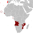
ファイル:Portuguese colonial war map1.PNG
表示
Portuguese_colonial_war_map1.PNG (360 × 392 ピクセル、ファイルサイズ: 12キロバイト、MIME タイプ: image/png)
ファイルの履歴
過去の版のファイルを表示するには、その版の日時をクリックしてください。
| 日付と時刻 | サムネイル | 寸法 | 利用者 | コメント | |
|---|---|---|---|---|---|
| 現在の版 | 2008年3月5日 (水) 10:17 |  | 360 × 392 (12キロバイト) | The Ogre | Enhanced visualization |
| 2007年11月26日 (月) 19:51 |  | 360 × 392 (12キロバイト) | Hoshie | added Cabinda, updated base map | |
| 2006年8月12日 (土) 14:46 |  | 360 × 392 (12キロバイト) | Nuno Tavares | == Summary == Map of the Portuguese colonies in Africa by the time of the Portuguese Colonial War (1961-1974). ==Source== <pre> 12:19, 8 April 2006 . . Mário (Talk | contribs) . . 360×392 (12,409 bytes) (Map of the Portuguese colonies i |
ファイルの使用状況
以下のページがこのファイルを使用しています:
グローバルなファイル使用状況
以下に挙げる他のウィキがこの画像を使っています:
- de.wikipedia.org での使用状況
- en-two.iwiki.icu での使用状況
- fr.wikipedia.org での使用状況
- pt.wikipedia.org での使用状況


