
ファイル:Qatar 31 January 2003.jpg

元のファイル (1,110 × 1,375 ピクセル、ファイルサイズ: 656キロバイト、MIME タイプ: image/jpeg)
ウィキメディア・コモンズのファイルページにある説明を、以下に表示します。
|
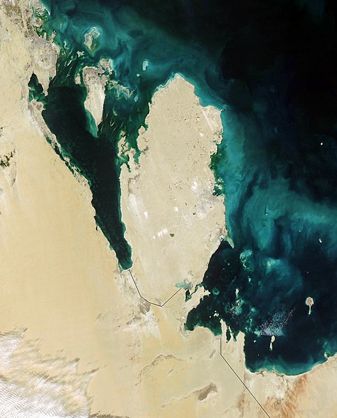
Qatar
This true-color Moderate Resolution Imaging Spectroradiometer (MODIS) image from January 31, 2003, featuresthe Persian Gulf in the Middle East. Seven countries sit on the Gulf(clockwise from top right): Iran, Oman, the United Arab Emirates, SaudiArabia, Qatar, Kuwait, and Iraq. In addition to the tip of the peninsulareaching toward Iran, Oman also stretches to the southeast along the Gulfof Oman (bottom right corner).
The Persian Gulf, officially known as The Gulf, features clouds ofblue and green in its dark waters. These clouds likely indicate a mixtureof sediment and microscopic marine plant life. At the top of The Gulf,where Kuwait, Iraq, and Iran meet, two rivers flow into the Gulf and addtan streaks to the water. These rivers are the Euphrates and the Tigris,the source of the Fertile Crescent valley and between which the ancientMesopotamian civilization flourished.
A number of fires were detected in this scene by MODIS and are markedin red. They are concentrated in southern Iraq and western Iran. The onesin southern Iraq are likely associated with oil wells. Snow can also beseen blanketing the Zagros Mountains of Iran at the upper center of theimage.
http://visibleearth.nasa.gov/view_rec.php?id=4981
| このファイルはアメリカ航空宇宙局(NASA)によって作成されたものです。NASAの著作権の方針では、特記事項が無い場合、NASAの資料はパブリックドメインとなります。 (詳しくはTemplate:PD-USGov、NASAの著作権の方針について(英語)又はジェット推進研究所(JPL)の画像使用に関するガイドライン(英語)をご覧ください。) |
||
 |
注意事項:
|
.jpg)
ファイルの履歴
過去の版のファイルを表示するには、その版の日時をクリックしてください。
| 日付と時刻 | サムネイル | 寸法 | 利用者 | コメント | |
|---|---|---|---|---|---|
| 現在の版 | 2005年10月26日 (水) 06:39 | | 1,110 × 1,375 (656キロバイト) | Brian0918 | Qatar This true-color Moderate Resolution Imaging Spectroradiometer (MODIS) image from January 31, 2003, featuresthe Persian Gulf in the Middle East. Seven countries sit on the Gulf(clockwise from top right): Iran, Oman, the United Arab Emirates, SaudiAr |
ファイルの使用状況
以下のページがこのファイルを使用しています:
グローバルなファイル使用状況
以下に挙げる他のウィキがこの画像を使っています:
- ar.wikipedia.org での使用状況
- az.wikipedia.org での使用状況
- bcl.wikipedia.org での使用状況
- bn.wikipedia.org での使用状況
- ca.wikipedia.org での使用状況
- ceb.wikipedia.org での使用状況
- de.wikivoyage.org での使用状況
- el.wikipedia.org での使用状況
- en-two.iwiki.icu での使用状況
- en.wikivoyage.org での使用状況
- es.wikipedia.org での使用状況
- fi.wikipedia.org での使用状況
- fr.wikipedia.org での使用状況
- he.wikipedia.org での使用状況
- he.wikivoyage.org での使用状況
- hr.wikipedia.org での使用状況
- it.wikipedia.org での使用状況
- it.wikivoyage.org での使用状況
- ko.wikipedia.org での使用状況
- mn.wikipedia.org での使用状況
- nl.wikipedia.org での使用状況
- nn.wikipedia.org での使用状況
- pl.wikipedia.org での使用状況
- pt.wikipedia.org での使用状況
- ru.wikipedia.org での使用状況
- sh.wikipedia.org での使用状況
- sv.wikipedia.org での使用状況
- tl.wikipedia.org での使用状況
- uk.wikipedia.org での使用状況
- www.wikidata.org での使用状況