
ファイル:Sanson Amerique Septentrionale 1650 UTA.jpg

このプレビューのサイズ: 800 × 561 ピクセル。 その他の解像度: 320 × 224 ピクセル | 640 × 448 ピクセル | 1,024 × 718 ピクセル | 1,280 × 897 ピクセル | 2,560 × 1,794 ピクセル | 3,836 × 2,688 ピクセル。
元のファイル (3,836 × 2,688 ピクセル、ファイルサイズ: 1.89メガバイト、MIME タイプ: image/jpeg)
ウィキメディア・コモンズのファイルページにある説明を、以下に表示します。
|
概要
| 題名 |
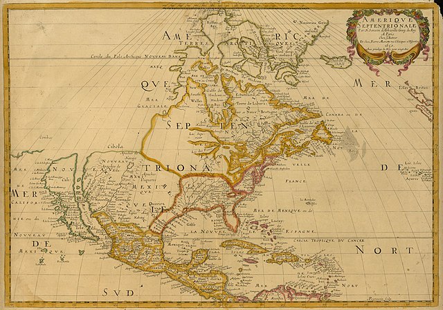
Français : Amerique Septentrionale |
||||||||||||||||||||||||||
| 記述 |
English: Sanson's landmark 1650 map of North America includes interesting details relating to chartered company operations in the northern and eastern part of the continent as well as the Caribbean. Employing a sinusoidal projection, its construction demonstrates considerable scientific acumen. Much of the Great Lakes system now appears, with Lakes Superior and Ontario named for the first time. Sanson's sources must have included the annual reports of the Jesuits which included eyewitness accounts of their missionary activities and explorations in association with the chartered fur companies. These augmented the earlier explorations of Champlain. There is also "Mon Royal", or Montreal, laid out as a trading site by Champlain in 1611. "N[ouvelle]. Anglet[erre]" refers to New England, while "Nouvelle Amsterdam" and "Nouvelle Hollandia" on the east coast allude to activities there of the New Netherland Company (beginning in 1614) and the Dutch WIC (beginning in 1625). There is even "N[ouvelle]. Suede" relating to the new settlements in the Delaware Valley of the New Sweden Company chartered by the Swedish government in 1638. |
||||||||||||||||||||||||||
| 日付 | 1650年または1651年 | ||||||||||||||||||||||||||
| 原典 | UTA Libraries Cartographic Connections: 地図 / テキスト | ||||||||||||||||||||||||||
| 作者 | |||||||||||||||||||||||||||
| 受入/取得方法 |
English: UTA Libraries Special Collections |
||||||||||||||||||||||||||
| Geotemporal data | |||||||||||||||||||||||||||
| Map location | 北アメリカ | ||||||||||||||||||||||||||
| Georeferencing | If inappropriate please set warp_status = skip to hide. | ||||||||||||||||||||||||||
| 出版地 | パリ | ||||||||||||||||||||||||||
| Archival data | |||||||||||||||||||||||||||
| コレクション |
|
||||||||||||||||||||||||||
| 寸法 | 高さ: 38 cm;幅: 54 cm | ||||||||||||||||||||||||||
| 技法 | 彩色された エングレービング | ||||||||||||||||||||||||||
| artwork-references |
Burden The Mapping of North America I、294 番、pp. 375−377 Schwartz and Ralph Ehrenberg The Mapping of America、5、61 番、pp. 111−112 Hayes Historical Atlas of Canada、1、p. 60 Martin および; Martin Maps of Texas and the Southwest、1、pp. 82−83 |
||||||||||||||||||||||||||

ライセンス

|
This file was provided to Wikimedia Commons by the University of Texas at Arlington Libraries as part of a cooperation project. The University of Texas at Arlington Libraries is part of the University of Texas at Arlington, a public research university located in Arlington, Texas.
|
|
著作者が1667年に死亡しているため、この著作物は、著作権の保護期間が著作者の死後100年以下である国・地域においてパブリックドメインの状態にあります。 この著作物は1929年1月1日以前に公表され、又はアメリカ合衆国著作権局に登録されたため、アメリカ合衆国においてパブリックドメインの状態にあります。 | |
| このファイルは著作権法の既知の制約(隣接権や関連する権利を含む)から自由であると特定されています。 | |
ファイルの履歴
過去の版のファイルを表示するには、その版の日時をクリックしてください。
| 日付と時刻 | サムネイル | 寸法 | 利用者 | コメント | |
|---|---|---|---|---|---|
| 現在の版 | 2022年2月8日 (火) 15:27 | | 3,836 × 2,688 (1.89メガバイト) | Michael Barera | == {{int:filedesc}} == {{Map |title = {{la|'''''Amerique Septentrionale'''''}} |description = {{en|Sanson's landmark 1650 map of North America includes interesting details relating to chartered company operations in the northern and eastern part of the continent as well as the Caribbean. Employing a sinusoidal projection, its construction demonstrates considerable scientific acumen. Much of the Great Lakes system now appears, with Lakes Superior and Ontario named for the f... |
ファイルの使用状況
以下のページがこのファイルを使用しています:
グローバルなファイル使用状況
以下に挙げる他のウィキがこの画像を使っています:
- de.wikipedia.org での使用状況
- en-two.iwiki.icu での使用状況
- es.wikipedia.org での使用状況
- fa.wikipedia.org での使用状況
- it.wikipedia.org での使用状況
- ko.wikipedia.org での使用状況
- pt.wikipedia.org での使用状況
- ru.wikipedia.org での使用状況