
ファイル:South West England counties 2009 map.svg

この SVG ファイルのこの PNG プレビューのサイズ: 764 × 599 ピクセル. その他の解像度: 306 × 240 ピクセル | 612 × 480 ピクセル | 979 × 768 ピクセル | 1,280 × 1,004 ピクセル | 2,560 × 2,008 ピクセル | 1,425 × 1,118 ピクセル。
元のファイル (SVG ファイル、1,425 × 1,118 ピクセル、ファイルサイズ: 1.83メガバイト)
ウィキメディア・コモンズのファイルページにある説明を、以下に表示します。
|
概要
| 解説 |
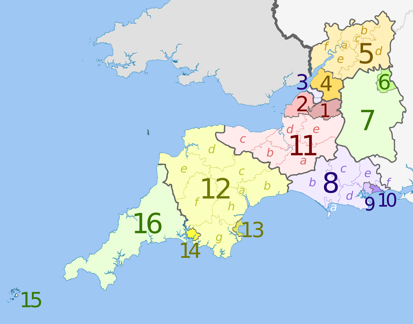
English: Map of the South West England region, showing its counties and administrative districts in 2009. The county colours are the same as those in File:English metropolitan and non-metropolitan counties 2009.svg.
For the districts since 1 April 2023, see File:South West England counties 2023 map.svg. Equirectangular map projection on WGS 84 datum, with N/S stretched 160% Geographic limits:
|
| 日付 | (UTC) |
| 原典 |
このファイルの派生元: |
| 作者 |
|
| その他のバージョン | File:South West England counties 2023 map.svg – version since 1 April 2023 |

| Map | Ceremonial county | Shire county / unitary | Districts |
|---|---|---|---|
 |
Somerset | 1. Bath and North East Somerset UA | |
| 2. North Somerset UA | |||
| 11. Somerset CC | a) South Somerset, b) Taunton Deane, c) West Somerset, d) Sedgemoor, e) Mendip | ||
| 3. Bristol UA | |||
| Gloucestershire | 4. South Gloucestershire UA | ||
| 5. Gloucestershire CC | a) Gloucester, b) Tewkesbury, c) Cheltenham, d) Cotswold, e) Stroud, f) Forest of Dean | ||
| Wiltshire | 6. Swindon UA | ||
| 7. Wiltshire UA | |||
| Dorset | 8. Dorset CC | a) Weymouth and Portland, b) West Dorset, c) North Dorset, d) Purbeck, e) East Dorset, f) Christchurch | |
| 9. Poole UA | |||
| 10. Bournemouth UA | |||
| Devon | 12. Devon CC | a) Exeter, b) East Devon, c) Mid Devon, d) North Devon, e) Torridge, f) West Devon, g) South Hams, h) Teignbridge | |
| 13. Torbay UA | |||
| 14. Plymouth UA | |||
| Cornwall | 15. Isles of Scilly sui generis UA | ||
| 16. Cornwall UA | |||
UA = unitary authority CC = county council
ライセンス
このファイルはクリエイティブ・コモンズ 表示-継承 3.0 非移植ライセンスのもとに利用を許諾されています。
帰属: Dr Greg and Nilfanion. Contains Ordnance Survey data © Crown copyright and database right 2011
- あなたは以下の条件に従う場合に限り、自由に
- 共有 – 本作品を複製、頒布、展示、実演できます。
- 再構成 – 二次的著作物を作成できます。
- あなたの従うべき条件は以下の通りです。
- 表示 – あなたは適切なクレジットを表示し、ライセンスへのリンクを提供し、変更があったらその旨を示さなければなりません。これらは合理的であればどのような方法で行っても構いませんが、許諾者があなたやあなたの利用行為を支持していると示唆するような方法は除きます。
- 継承 – もしあなたがこの作品をリミックスしたり、改変したり、加工した場合には、あなたはあなたの貢献部分を元の作品とこれと同一または互換性があるライセンスの下に頒布しなければなりません。
元のアップロードログ
This image is a derivative work of the following images:
- File:South_West_England_districts_2011_map.svg licensed with Cc-by-sa-3.0, GFDL
- 2011-05-01T19:06:01Z Nilfanion 1425x1118 (1924863 Bytes) == Summary == {{Information |Description=Map of the [[w:South West England|South West England]] region showing the administrative districts. Equirectangular map projection on WGS 84 datum, with N/S stretched 160% Geographic
- File:English_ceremonial_counties_2010.svg licensed with Cc-by-sa-3.0, GFDL
- 2010-11-23T16:39:55Z Nilfanion 1108x1345 (308868 Bytes) thicker lines
- 2010-11-23T16:20:19Z Nilfanion 1108x1345 (301520 Bytes) tweaks
- 2010-10-26T20:34:20Z Nilfanion 817x990 (1391832 Bytes) {{Information |Description=Map showing the [[w:ceremonial counties of England]] including the City of London, in 2010. Equirectangular map projection on WGS 84 datum, with N/S stretched 170% Geographic limits: *West: 6.75W
Uploaded with derivativeFX
ファイルの履歴
過去の版のファイルを表示するには、その版の日時をクリックしてください。
| 日付と時刻 | サムネイル | 寸法 | 利用者 | コメント | |
|---|---|---|---|---|---|
| 現在の版 | 2012年5月5日 (土) 20:07 | | 1,425 × 1,118 (1.83メガバイト) | Dr Greg | lighten black boundary line |
| 2012年5月2日 (水) 20:47 |  | 1,425 × 1,118 (1.83メガバイト) | Dr Greg | == {{int:filedesc}} == {{Information |Description={{en|Map of the South West England region, showing its counties and administrative districts. The county colours are the same as those in [[:File:English metropolitan and non-me... |
ファイルの使用状況
以下のページがこのファイルを使用しています:
グローバルなファイル使用状況
以下に挙げる他のウィキがこの画像を使っています:
- ar.wikipedia.org での使用状況
- fa.wikipedia.org での使用状況
- fr.wikipedia.org での使用状況
- mr.wikipedia.org での使用状況
- pt.wikipedia.org での使用状況
- tr.wikipedia.org での使用状況
- vi.wikipedia.org での使用状況
- vls.wikipedia.org での使用状況
- zh-yue.wikipedia.org での使用状況