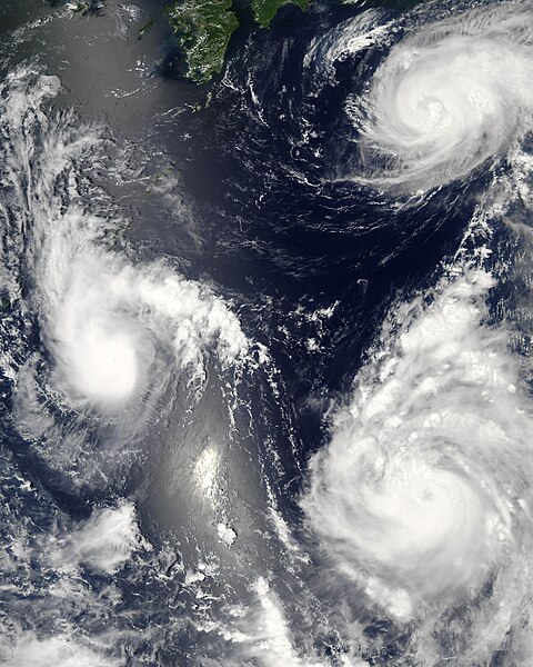
ファイル:Maria, Bopha and Saomai 2006-08-07 0435Z.jpg
表示

このプレビューのサイズ: 480 × 600 ピクセル。 その他の解像度: 192 × 240 ピクセル | 384 × 480 ピクセル | 614 × 768 ピクセル | 819 × 1,024 ピクセル | 1,638 × 2,048 ピクセル | 7,200 × 9,000 ピクセル。
元のファイル (7,200 × 9,000 ピクセル、ファイルサイズ: 7.6メガバイト、MIME タイプ: image/jpeg)
ファイルの履歴
過去の版のファイルを表示するには、その版の日時をクリックしてください。
| 日付と時刻 | サムネイル | 寸法 | 利用者 | コメント | |
|---|---|---|---|---|---|
| 現在の版 | 2006年8月8日 (火) 03:06 |  | 7,200 × 9,000 (7.6メガバイト) | Good kitty | == Summary == {{Information |Description=Three different typhoons were spinning over the western Pacific Ocean on August 7, 2006, when the Moderate Resolution Imaging Spectroradiometer (MODIS) on NASA’s Aqua satellite acquired this image. The strongest |
ファイルの使用状況
以下のページがこのファイルを使用しています:
グローバルなファイル使用状況
以下に挙げる他のウィキがこの画像を使っています:
- ar.wikipedia.org での使用状況
- az.wikipedia.org での使用状況
- bg.wikipedia.org での使用状況
- bh.wikipedia.org での使用状況
- crh.wikipedia.org での使用状況
- cs.wikipedia.org での使用状況
- de.wikipedia.org での使用状況
- en-two.iwiki.icu での使用状況
- Typhoon
- Typhoon Saomai
- Tropical cyclone
- Wikipedia:Picture peer review/Archives/Archive2006
- User:Plasticup/MyFavorites
- Typhoon Maria (2006)
- User talk:Hurricanehink/Archive 23
- User talk:Thegreatdr/2012archive
- Wikipedia:Wikipedia Signpost/2013-11-20/Traffic report
- Wikipedia:Wikipedia Signpost/Single/2013-11-20
- Wikipedia:Top 25 Report/November 10 to 16, 2013
- User:Tfmbty/2006 Pacific typhoon season
- User:SongdaTalas/Archives of Former Articles
- en.wiktionary.org での使用状況
- es.wikipedia.org での使用状況
- fi.wikipedia.org での使用状況
- hi.wikipedia.org での使用状況
- id.wiktionary.org での使用状況
- incubator.wikimedia.org での使用状況
- ja.wikibooks.org での使用状況
- ko.wikipedia.org での使用状況
- lo.wikipedia.org での使用状況
- ms.wikipedia.org での使用状況
- my.wikipedia.org での使用状況
- nn.wikipedia.org での使用状況
- no.wikipedia.org での使用状況
- pt.wikipedia.org での使用状況
- ro.wikipedia.org での使用状況
- ru.wikipedia.org での使用状況
- szy.wikipedia.org での使用状況
- th.wikipedia.org での使用状況
- tk.wikipedia.org での使用状況
- tr.wikipedia.org での使用状況
- tt.wikipedia.org での使用状況
このファイルのグローバル使用状況を表示する。


