
ファイル:USACE Robert F Henry Lock and Dam.jpg

このプレビューのサイズ: 800 × 540 ピクセル。 その他の解像度: 320 × 216 ピクセル | 640 × 432 ピクセル | 1,024 × 692 ピクセル | 1,500 × 1,013 ピクセル。
元のファイル (1,500 × 1,013 ピクセル、ファイルサイズ: 456キロバイト、MIME タイプ: image/jpeg)
ウィキメディア・コモンズのファイルページにある説明を、以下に表示します。
|
| 解説 |
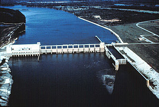
English: Aerial view of the Robert F. Henry Lock and Dam, formerly known as the Jones Bluff Lock and Dam, on the Alabama River. The dam spans the border between Autauga County and Lowndes County, Alabama, USA. The dam impounds R. E. “Bob” Woodruff Lake on the Alabama River. The lock and dam are located at river mile 245.4. The U.S. Army Corps of Engineers maintains the lock and dam for navigation on the Alabama River.
Coordinates: 32°19′25.04″N 86°46′59.04″W / 32.3236222°N 86.7830667°W |
|||
| 場所 | Autauga County and Lowndes County, Alabama, USA | |||
| 日付 | ||||
| 原典 |
U.S. Army Corps of Engineers Digital Visual Library Image page Image description page Digital Visual Library home page |
|||
| 作者 | Adrien Lamarre, U.S. Army Corps of Engineers | |||
| 許可 (ファイルの再利用) |
|
ファイルの履歴
過去の版のファイルを表示するには、その版の日時をクリックしてください。
| 日付と時刻 | サムネイル | 寸法 | 利用者 | コメント | |
|---|---|---|---|---|---|
| 現在の版 | 2007年4月28日 (土) 21:40 | | 1,500 × 1,013 (456キロバイト) | DanMS | {{Information | Description = {{en|Aerial view of the Robert F. Henry Lock and Dam, formerly known as the Jones Bluff Lock and Dam, on the Alabama River. The dam spans the border between Autauga County and Lowndes County, Alabama, USA. The dam impounds |
ファイルの使用状況
以下のページがこのファイルを使用しています:
グローバルなファイル使用状況
以下に挙げる他のウィキがこの画像を使っています:
- ar.wikipedia.org での使用状況
- de.wikipedia.org での使用状況
- en-two.iwiki.icu での使用状況
- fy.wikipedia.org での使用状況
- it.wikipedia.org での使用状況
- jv.wikipedia.org での使用状況
- www.wikidata.org での使用状況
- xmf.wikipedia.org での使用状況