
ファイル:US FRONTIER STRIP.PNG
高解像度版はありません。
US_FRONTIER_STRIP.PNG (572 × 371 ピクセル、ファイルサイズ: 15キロバイト、MIME タイプ: image/png)
ウィキメディア・コモンズのファイルページにある説明を、以下に表示します。
|
概要
| 解説 |
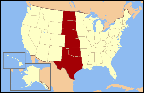
English: Frontier Strip refers to the six U.S. states from North Dakota south to Texas. These states form a nearly straight line from north to south and roughly correspond to the Great Plains region of the United States. The term Frontier Strip is probably correlated to the 1880 census, where these six states, some of which were territories at the time, were part of the "Frontier Line," the geographic designation by the U.S. Census Bureau that proclaimed where the civilitation of the Eastern United States ended and the historic American Wild West began. In the 1890 census, it stated, "Up to and including 1880 the country had a frontier of settlement, but at present the unsettled area has been so broken into by isolated bodies of settlement that there can hardly be said to be a frontier line. In the discussion of its extent, its westward movement, etc., it can not, therefore, any longer have a place in the census reports." NOTE: On 2 January 2018 Wikipedia:Articles for deletion/Frontier Strip determined that "frontier strip" is not actually a recognized geographical term, so this graphic should no longer be used. |
| 原典 | コンピュータが読み取れる情報は提供されていませんが、投稿者自身による著作物だと推定されます(著作権の主張に基づく) |
| 作者 | コンピュータが読み取れる情報は提供されていませんが、Jannizzだと推定されます(著作権の主張に基づく) |
ライセンス
この作品の著作権者である私は、この作品を以下のライセンスで提供します。

|
この文書は、フリーソフトウェア財団発行のGNUフリー文書利用許諾書 (GNU Free Documentation License) 1.2またはそれ以降のバージョンの規約に基づき、複製や再配布、改変が許可されます。不可変更部分、表紙、背表紙はありません。このライセンスの複製は、GNUフリー文書利用許諾書という章に含まれています。 |
| このファイルはクリエイティブ・コモンズ 表示-継承 3.0 非移植ライセンスのもとに利用を許諾されています。 | ||
| ||
| このライセンスのテンプレートは、GFDLのライセンス・アップデートによりこのファイルに追加されたものです。 |
あなたは上記のライセンスから、どれか一つ以上を選択できます。
ファイルの履歴
過去の版のファイルを表示するには、その版の日時をクリックしてください。
| 日付と時刻 | サムネイル | 寸法 | 利用者 | コメント | |
|---|---|---|---|---|---|
| 現在の版 | 2007年7月3日 (火) 15:43 | | 572 × 371 (15キロバイト) | Jannizz | == Summary == Frontier Strip refers to the six U.S. states from North Dakota south to Texas. These states form a nearly straight line from north to south and roughly correspond to the Great Plains region of the United States. The term Frontier Strip i |
ファイルの使用状況
以下の 2 ページがこのファイルを使用しています:
グローバルなファイル使用状況
以下に挙げる他のウィキがこの画像を使っています:
- fi.wikipedia.org での使用状況
- fr.wikipedia.org での使用状況
- he.wikipedia.org での使用状況
- no.wikipedia.org での使用状況
- pt.wikipedia.org での使用状況
- zh-two.iwiki.icu での使用状況