
ファイル:WV plateau.jpg

元のファイル (800 × 784 ピクセル、ファイルサイズ: 472キロバイト、MIME タイプ: image/jpeg)
ウィキメディア・コモンズのファイルページにある説明を、以下に表示します。
|
en.wikipedia からコモンズに Maksim によって移動されました。
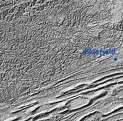
Relief Map: Cumberland Plateau, West Virginia and "Ridge and Valley" region of Virginia
Image is Shaded Relief Imagery, derived from the US Geological Survey National Elevation Dataset, modified by Pollinator. USGS-authored or produced data and information are in the public domain.
(Point of reference: Bluefield, West Virginia is on the Virginia/West Virginia border)
On the southeastern portion of this map is the folded Appalachians of Virginia, also known as the Ridge-and-valley Appalachians, which are the roots of true ancient mountains, uplifted once again, with the harder rock layers forming ridges and the more erodable rocks becoming valleys.
A major fault line runs from southwest to northeast dividing the folded mountains from the Cumberland Plateau of West Virginia, a dissected plateau that forms the majority of the image. This area of sedimentary rock (including many coal) veins is, geologically speaking, not true mountains, but merely was uplifted and eroded. Note that the area is actually more rugged than the folded mountains, though not as high.
この画像およびメディアは、アメリカ合衆国内務省の実務機関であるアメリカ地質調査所に属する者が職務上作成した著作物のみで構成されているため、アメリカ合衆国国内でパブリックドメインの状態にあります。詳細についてはUSGSの著作物に関する取扱い(英語)をご覧ください。
|
| date/time | username | edit summary |
|---|---|---|
| 01:20, 12 February 2005 | en:User:RedWolf | ({{PD-USGov-Interior-USGS}}) |
| 06:23, 8 November 2004 | en:User:SimonP | |
| 20:08, 21 August 2004 | en:User:Pollinator | (tweak and wikify) |
| 19:55, 21 August 2004 | en:User:Pollinator | (public domain) |
| 19:52, 21 August 2004 | en:User:Pollinator | (link repair) |
| 19:50, 21 August 2004 | en:User:Pollinator | (Photo caption) |
| 19:38, 21 August 2004 | en:User:Pollinator | (Relief Map: Cumberland Plateau, West Virginia and "Ridge and Valley" region of Virginia) |
元のアップロードログ
Legend: (cur) = this is the current file, (del) = delete this old version, (rev) = revert to this old version.
Click on date to download the file or see the image uploaded on that date.
- (del) (cur) 19:38, 21 August 2004 . . en:User:Pollinator Pollinator ( en:User_talk:Pollinator Talk) . . 800x784 (483656 bytes) (Relief Map: Cumberland Plateau, West Virginia and "Ridge and Valley" region of Virginia)
ファイルの履歴
過去の版のファイルを表示するには、その版の日時をクリックしてください。
| 日付と時刻 | サムネイル | 寸法 | 利用者 | コメント | |
|---|---|---|---|---|---|
| 現在の版 | 2006年2月5日 (日) 18:47 | | 800 × 784 (472キロバイト) | Maksim | La bildo estas kopiita de wikipedia:en. La originala priskribo estas: Relief Map: Cumberland Plateau, West Virginia and "Ridge and Valley" region of Virginia Image is Shaded Relief Imagery, derived from the US Geological Survey National Elevation Datase |
ファイルの使用状況
以下のページがこのファイルを使用しています:
グローバルなファイル使用状況
以下に挙げる他のウィキがこの画像を使っています:
- ca.wikipedia.org での使用状況
- da.wikipedia.org での使用状況
- en-two.iwiki.icu での使用状況
- eo.wikipedia.org での使用状況
- es.wikipedia.org での使用状況
- it.wikipedia.org での使用状況
- nn.wikipedia.org での使用状況
- pt.wikipedia.org での使用状況