
ファイル:Waterpocket Fold - Looking south from the Strike Valley Overlook.jpg
高解像度版はありません。
Waterpocket_Fold_-_Looking_south_from_the_Strike_Valley_Overlook.jpg (800 × 600 ピクセル、ファイルサイズ: 592キロバイト、MIME タイプ: image/jpeg)
ウィキメディア・コモンズのファイルページにある説明を、以下に表示します。
|
| 解説 |
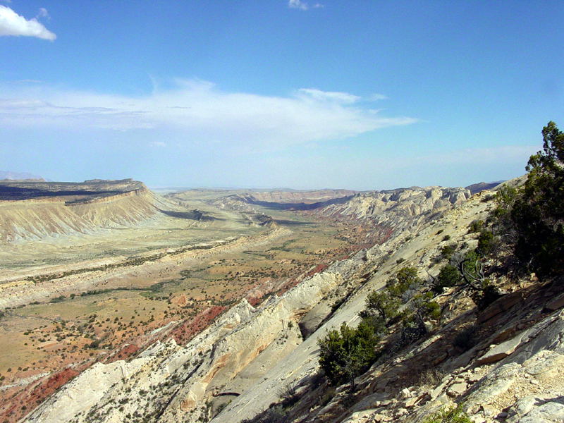
English: Perhaps the most amazing view in the region is this scene looking south from the Strike Valley Overlook along a great, warping arc in the greater Waterpocket Fold. The scene encompasses about a 2 kilometer thick section of sedimentary rocks and landscape features representing more than 200 million years of earth surface processes and conditions. The oldest sedimentary rocks on the right (the Navajo Sandstone) represents a great blanket of desert dunes that extended across the region at the close of Triassic time. Morrison Formation in the center represents the changes in Jurassic time when the great dune fields gave way to coastal floodplains, swamps, and shallow inland seas. The Mancos Shale represents the formation of a great inland Western Interior Seaway that lasted in the region through almost all of Cretaceous time. Finally this seaway withdrew at the close of Cretaceous time, the land rose, and volcanoes of the Henry Mountains formed in early Tertiary time (probably during the Oligocene Epoch between 37 and 24 million years ago). Since middle Tertiary time, the land has been steadily rising and eroding, perhaps at an increasing rate with the development of the modern Colorado River system across the region. |
|||
| 日付 | 2003年8月8日 (Exifデータによる) | |||
| 原典 | USGS – 3dparks.wr.usgs.gov | |||
| 作者 | 不明 | |||
| 許可 (ファイルの再利用) |
|
ファイルの履歴
過去の版のファイルを表示するには、その版の日時をクリックしてください。
| 日付と時刻 | サムネイル | 寸法 | 利用者 | コメント | |
|---|---|---|---|---|---|
| 現在の版 | 2006年3月16日 (木) 03:05 | | 800 × 600 (592キロバイト) | Mav | USGS image from [http://3dparks.wr.usgs.gov/capitol2/html/3d4665.html] Perhaps the most amazing view in the region is this scene looking south from the Strike Valley Overlook along a great, warping arc in the greater Waterpocket Fold. The scene encompass |
ファイルの使用状況
以下のページがこのファイルを使用しています:
グローバルなファイル使用状況
以下に挙げる他のウィキがこの画像を使っています:
- ar.wikipedia.org での使用状況
- bg.wikipedia.org での使用状況
- en-two.iwiki.icu での使用状況
- es.wikipedia.org での使用状況
- fr.wikipedia.org での使用状況
- gl.wikipedia.org での使用状況
- lt.wikipedia.org での使用状況
- tr.wikipedia.org での使用状況