
「コム (カルヴァドス県)」の版間の差分
削除された内容 追加された内容
fr:Commes le 2 janvier 2020 à 22:58. (CET UTC+1)より地理、由来、人口統計を翻訳 |
m Bot作業依頼: 翻訳用出典テンプレートのsubst展開 (Template:Cite web/French) - log |
||
| 33行目: | 33行目: | ||
==歴史== |
==歴史== |
||
2007年から実施された考古学調査によると、エスキュールの丘にあるモン・カヴァリエの陣地において、[[新石器時代]]または[[青銅器時代]]に人が定住していたことが明らかになった<ref>{{ |
2007年から実施された考古学調査によると、エスキュールの丘にあるモン・カヴァリエの陣地において、[[新石器時代]]または[[青銅器時代]]に人が定住していたことが明らかになった<ref>{{cite web2|title=Les sites fortifiés de hauteur de La Tène finale en Basse-Normandie|url=https://www.academia.edu/859978/les_sites_fortifiés_de_hauteur_de_la_tène_finale_en_Basse-norMandie|author=Pierre Giraud|website=Academia.edu|format=pdf|access-date=12 June 2015|publication-date=}}, page 82</ref>。 |
||
==人口統計== |
==人口統計== |
||
2021年4月15日 (木) 23:27時点における版
| Commes | |
|---|---|
|
 | |
| 行政 | |
| 国 |
|
| 地域圏 (Région) | ノルマンディー地域圏 |
| 県 (département) |
カルヴァドス県 |
| 郡 (arrondissement) | バイユー郡 |
| 小郡 (canton) | バイユー小郡 |
| INSEEコード | 14172 |
| 郵便番号 | 14520 |
| 市長(任期) |
フェルナン・ポレ (2014年-2020年) |
| 自治体間連合 (fr) | fr:Communauté de communes de Bayeux Intercom |
| 人口動態 | |
| 人口 |
401人 (2017年) |
| 人口密度 | 60人/km2 |
| 住民の呼称 | Commésien |
| 地理 | |
| 座標 | 北緯49度20分16秒 西経0度44分10秒 / 北緯49.337778度 西経0.736111度座標: 北緯49度20分16秒 西経0度44分10秒 / 北緯49.337778度 西経0.736111度 |
| 標高 |
平均:m 最低:0 m 最高:77 m |
| 面積 | 6.64km2 |
 Commes | |


コム (Commes)は、フランス、ノルマンディー地域圏、カルヴァドス県のコミューン。
地理
コムはエスキュールの丘の上にあり、ポルタン=ベッサンから2km、バイユーの北8kmのところにある。
由来
地名は、既に1270年に現在のつづりであったことが証明されている[1]。地名の起源は不明である。ガリア語の人名Commos[2]またはCommus[1]、ラテン語のComusから派生したとみられる[2]。自治体の土地を示す、ラテン語の語句communisから継承されたとみることもできる[3]。
歴史
2007年から実施された考古学調査によると、エスキュールの丘にあるモン・カヴァリエの陣地において、新石器時代または青銅器時代に人が定住していたことが明らかになった[4]。
人口統計
2017年時点のコミューンの人口は401人で、2012年当時の人口より5.25%増加した[5]
| 1962年 | 1968年 | 1975年 | 1982年 | 1990年 | 1999年 | 2006年 | 2011年 | 2017年 |
|---|---|---|---|---|---|---|---|---|
| 350 | 324 | 278 | 360 | 382 | 397 | 411 | 391 | 401 |
参照元:1962年から1999年までは複数コミューンに住所登録をする者の重複分を除いたもの。それ以降は当該コミューンの人口統計によるもの。1999年までEHESS/Cassini[6]、2006年以降INSEE[7][8]
史跡
- ボスク城館 - 18世紀
- ノートルダム教会 - 11世紀。1897年再建。歴史的記念物[9]
- マノワール・ド・コム - 1869年から1873年にかけ、ジャン=ルイ・パスカルにより再建。
- 納屋と教会の農場、玄関
-

ノートルダム教会 -
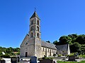
ノートルダム教会 -

教会の農場の玄関 -

納屋 -

戦没者記念碑


脚注
- ^ a b Ernest Nègre, Toponymie générale de la France, t. 1 : Formations préceltique, celtiques, romanes, Genève, (lire en ligne), p. 231
- ^ a b Albert Dauzat および Charles Rostaing, Dictionnaire étymologique des noms de lieux en France, Paris, Larousse,
- ^ René Lepelley, Noms de lieux de Normandie et des îles Anglo-Normandes, Paris, Bonneton, (ISBN 2-86253-247-9), p. 141
- ^ Pierre Giraud. "Les sites fortifiés de hauteur de La Tène finale en Basse-Normandie" (pdf). Academia.edu. 2015年6月12日閲覧。, page 82
- ^ Population municipale légale en vigueur au 1er janvier 2020, millésimée 2017, définie dans les limites territoriales en vigueur au 1er janvier 2019, date de référence statistique : 1er janvier 2017.
- ^ http://cassini.ehess.fr/cassini/fr/html/fiche.php?select_resultat=10008
- ^ https://www.insee.fr/fr/statistiques/4269674?geo=COM-14172
- ^ http://www.insee.fr
- ^ https://www.pop.culture.gouv.fr/notice/merimee/PA00111238
| 典拠管理データベース: 国立図書館 |
|---|