
ファイル:British main lines railway diagram.png

このプレビューのサイズ: 421 × 599 ピクセル。 その他の解像度: 168 × 240 ピクセル | 337 × 480 ピクセル | 539 × 768 ピクセル | 719 × 1,024 ピクセル | 2,464 × 3,508 ピクセル。
元のファイル (2,464 × 3,508 ピクセル、ファイルサイズ: 558キロバイト、MIME タイプ: image/png)
ウィキメディア・コモンズのファイルページにある説明を、以下に表示します。
|

|
このファイルのベクター画像 (SVG) が利用できます。 使う目的に対し、元画像よりもSVGがより優れている場合、SVG画像を使用して下さい。
File:British main lines railway diagram.png → File:British main lines railway diagram.svg
|
 |
概要
| 解説 |
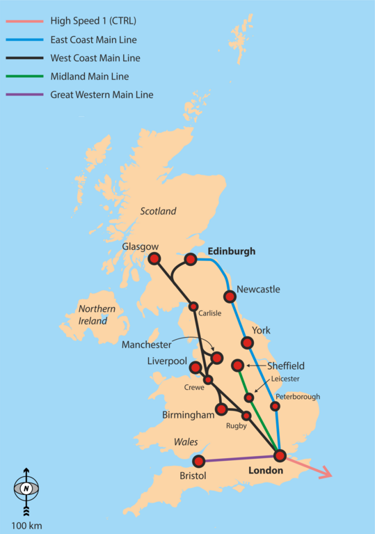
English: Simple overview map of the WCML, ECML, Midland Main Line and CTRL. |
| 日付 | |
| 原典 | 投稿者自身による著作物 |
| 作者 | Classical geographer |
Background is File:Uk_outline_map.png; ECML and WCML are based on File:Uk outline map with ECML railway.PNG and File:Uk outline map with WCML railway.PNG.
ライセンス
この作品の著作権者である私は、この作品を以下のライセンスで提供します。
このファイルはクリエイティブ・コモンズ 表示-継承 3.0 非移植ライセンスのもとに利用を許諾されています。
- あなたは以下の条件に従う場合に限り、自由に
- 共有 – 本作品を複製、頒布、展示、実演できます。
- 再構成 – 二次的著作物を作成できます。
- あなたの従うべき条件は以下の通りです。
- 表示 – あなたは適切なクレジットを表示し、ライセンスへのリンクを提供し、変更があったらその旨を示さなければなりません。これらは合理的であればどのような方法で行っても構いませんが、許諾者があなたやあなたの利用行為を支持していると示唆するような方法は除きます。
- 継承 – もしあなたがこの作品をリミックスしたり、改変したり、加工した場合には、あなたはあなたの貢献部分を元の作品とこれと同一または互換性があるライセンスの下に頒布しなければなりません。
ファイルの履歴
過去の版のファイルを表示するには、その版の日時をクリックしてください。
| 日付と時刻 | サムネイル | 寸法 | 利用者 | コメント | |
|---|---|---|---|---|---|
| 現在の版 | 2016年9月6日 (火) 17:29 | | 2,464 × 3,508 (558キロバイト) | Rob984 | Showing all of Ireland but not even part of France is odd. Especially considering there are UK-France high speed routes. |
| 2016年9月6日 (火) 04:48 |  | 2,503 × 3,627 (849キロバイト) | Classical geographer | Added Western Main Line. Decreased font size of junctions. Note the map is still intended for a quick overview, perhaps at the top of an article. | |
| 2010年7月22日 (木) 07:29 |  | 1,333 × 1,777 (188キロバイト) | Classical geographer | Chester should have been Crewe. | |
| 2010年7月21日 (水) 19:17 |  | 1,666 × 2,221 (904キロバイト) | Classical geographer | Resized, because was over 12.5 million pixels. | |
| 2010年7月21日 (水) 19:15 |  | 3,333 × 4,444 (600キロバイト) | Classical geographer | {{Information |Description={{en|1=Simple overview map of the WCML, ECML, Midland Main Line and CTRL.}} |Source={{own}} |Author=Classical geographer |Date=2010-07-21 |Permission= |other_versions= }} Background is [[:File:Uk_ou |
ファイルの使用状況
以下の 2 ページがこのファイルを使用しています:
グローバルなファイル使用状況
以下に挙げる他のウィキがこの画像を使っています:
- en-two.iwiki.icu での使用状況
- fa.wikipedia.org での使用状況
- it.wikipedia.org での使用状況
- nl.wikipedia.org での使用状況
- no.wikipedia.org での使用状況
- pnb.wikipedia.org での使用状況
- pt.wikipedia.org での使用状況
- ru.wikipedia.org での使用状況
- ur.wikipedia.org での使用状況
- zh-two.iwiki.icu での使用状況