
ファイル:LPTA map.png

このプレビューのサイズ: 501 × 600 ピクセル。 その他の解像度: 200 × 240 ピクセル | 401 × 480 ピクセル | 653 × 782 ピクセル。
元のファイル (653 × 782 ピクセル、ファイルサイズ: 60キロバイト、MIME タイプ: image/png)
ウィキメディア・コモンズのファイルページにある説明を、以下に表示します。
|

|
この地図画像は、ベクターイメージである SVG ファイルとして再作成されるべきです。これにはいくつかの利点があります。詳しくはCommons:Media for cleanupを参照してください。この画像の SVG 形式がすでに利用可能である場合は、アップロードしてください。アップロード後、この画像にあるこのテンプレートを{{Vector version available|新しい画像ファイル名.svg}}テンプレートで置き換えてください。
|
概要
| 解説 |
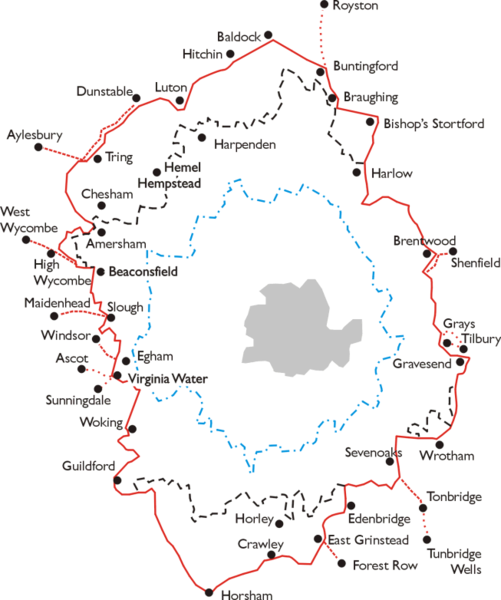
Português: Mapa da London Passenger Transport Area.
English: Map of the area of the London Passenger Transport Board 1933 - 1947. Simplified map based on leaflet issued by LPTB, July 1933. |
| 日付 | 2006年8月26日 (当初のアップロード日) |
| 原典 | en.wikipedia からコモンズに移動されました。 |
| 作者 | 英語版ウィキペディアのLozleaderさん |
ライセンス
この作品の著作権者であるLozleader (英語版ウィキペディアの利用者)は、この作品を以下のライセンスで提供しています。
| このファイルはクリエイティブ・コモンズ 表示-継承 3.0 非移植ライセンスのもとに利用を許諾されています。 著作権に示した解釈の下ライセンスされるものとします。 | ||
| 帰属: Lozleader (英語版ウィキペディアの利用者) | ||
| ||
| このライセンスのテンプレートは、GFDLのライセンス・アップデートによりこのファイルに追加されたものです。 |

|
この文書は、フリーソフトウェア財団発行のGNUフリー文書利用許諾書 (GNU Free Documentation License) 1.2またはそれ以降のバージョンの規約に基づき、複製や再配布、改変が許可されます。不可変更部分、表紙、背表紙はありません。このライセンスの複製は、GNUフリー文書利用許諾書という章に含まれています。 著作権に示した解釈の下ライセンスされるものとします。 |
元のアップロードログ
元のファイルページはこちら。以下の利用者は全てen.wikipediaに属します。
- 2006-08-26 20:03 Lozleader 653×782× (61181 bytes) Map of the area of the [[London Passenger Transport Board]] [[1933]] - [[1947]]. Simplified map based on leaflet issued by LPTB, July [[1933]]. The London Passenger Transport Area is outlined in red, with the board's "special area", in which it had a mo
ファイルの履歴
過去の版のファイルを表示するには、その版の日時をクリックしてください。
| 日付と時刻 | サムネイル | 寸法 | 利用者 | コメント | |
|---|---|---|---|---|---|
| 現在の版 | 2011年5月4日 (水) 09:32 | | 653 × 782 (60キロバイト) | Voyager | larger version |
| 2009年2月24日 (火) 01:31 |  | 300 × 359 (62キロバイト) | Richard Melo da Silva | {{Information |Description={{pt|Mapa da London Passenger Transport Area.}} {{en|Map of the area of the London Passenger Transport Board 1933 - 1947. Simplified map based on leaflet issued by LPTB, July 1933. The London Passenger Transport Area is outlined |
ファイルの使用状況
以下のページがこのファイルを使用しています:
グローバルなファイル使用状況
以下に挙げる他のウィキがこの画像を使っています:
- ar.wikipedia.org での使用状況
- ca.wikipedia.org での使用状況
- da.wikipedia.org での使用状況
- de.wikipedia.org での使用状況
- en-two.iwiki.icu での使用状況
- hu.wikipedia.org での使用状況
- pt.wikipedia.org での使用状況
- simple.wikipedia.org での使用状況