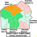
ファイル:Map of Adams County Pennsylvania School Districts.png
表示
Map_of_Adams_County_Pennsylvania_School_Districts.png (291 × 291 ピクセル、ファイルサイズ: 12キロバイト、MIME タイプ: image/png)
ファイルの履歴
過去の版のファイルを表示するには、その版の日時をクリックしてください。
| 日付と時刻 | サムネイル | 寸法 | 利用者 | コメント | |
|---|---|---|---|---|---|
| 現在の版 | 2006年6月21日 (水) 21:27 |  | 291 × 291 (12キロバイト) | Ruhrfisch | {{Information| |Description= Map of Adams County, Pennsylvania, United States Public School Districts |Source= taken from US Census website [http://factfinder.census.gov/] and modified by User:Ruhrfisch, one SD boundary change since 2000 based on PA |
ファイルの使用状況
以下のページがこのファイルを使用しています:
グローバルなファイル使用状況
以下に挙げる他のウィキがこの画像を使っています:
- en-two.iwiki.icu での使用状況
- Adams County, Pennsylvania
- Gettysburg College
- Harrisburg Area Community College
- Bermudian Springs School District
- Gettysburg Area School District
- Littlestown Area School District
- Delone Catholic High School
- Fairfield Area School District
- Conewago Valley School District
- Upper Adams School District
- Gettysburg Area High School
- Littlestown Senior High School
- Adams County Christian Academy
- Bermudian Springs High School
- Biglerville High School
- Fairfield Area High School
- New Oxford High School
- Template:Education in Adams County, Pennsylvania
- pl.wikipedia.org での使用状況
- zh-two.iwiki.icu での使用状況


