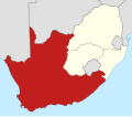
ファイル:Map of the provinces of South Africa 1910-1976 with the Cape highlighted.svg
表示

この SVG ファイルのこの PNG プレビューのサイズ: 684 × 599 ピクセル. その他の解像度: 274 × 240 ピクセル | 548 × 480 ピクセル | 876 × 768 ピクセル | 1,168 × 1,024 ピクセル | 2,337 × 2,048 ピクセル | 809 × 709 ピクセル。
元のファイル (SVG ファイル、809 × 709 ピクセル、ファイルサイズ: 523キロバイト)
ファイルの履歴
過去の版のファイルを表示するには、その版の日時をクリックしてください。
| 日付と時刻 | サムネイル | 寸法 | 利用者 | コメント | |
|---|---|---|---|---|---|
| 現在の版 | 2011年3月7日 (月) 23:26 |  | 809 × 709 (523キロバイト) | Htonl | == Summary == {{Information |Description ={{en|1=Map of South Africa showing the provinces as they were from 1910 to 1976, with the Cape of Good Hope Province highlighted. Based on File:Map of South Africa with provincial borders 1910-1976.svg.}} |
ファイルの使用状況
以下のページがこのファイルを使用しています:
グローバルなファイル使用状況
以下に挙げる他のウィキがこの画像を使っています:
- en-two.iwiki.icu での使用状況
- eu.wikipedia.org での使用状況
- it.wikipedia.org での使用状況

