
ファイル:Mono Lake South Tufa Area (2013) 14.JPG
このプレビューのサイズ: 800 × 532 ピクセル。 その他の解像度: 320 × 213 ピクセル | 640 × 426 ピクセル | 1,024 × 681 ピクセル | 1,280 × 851 ピクセル | 2,560 × 1,702 ピクセル | 4,512 × 3,000 ピクセル。
元のファイル (4,512 × 3,000 ピクセル、ファイルサイズ: 7.72メガバイト、MIME タイプ: image/jpeg)
ウィキメディア・コモンズのファイルページにある説明を、以下に表示します。
|
概要
| 解説 |
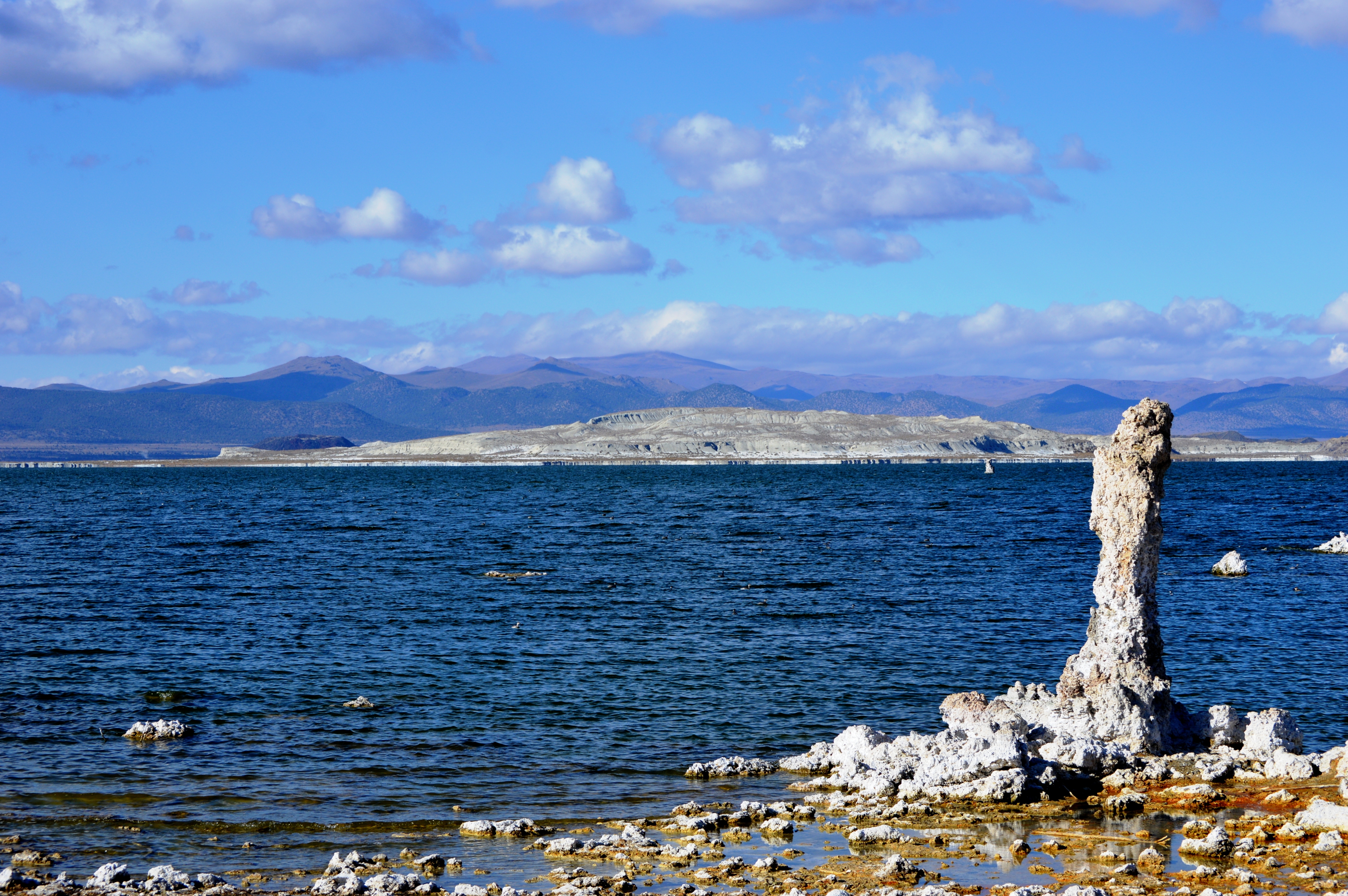
English: Mono Lake as seen from the "South Tufa" area. In the foreground (on right) is one of numerous tufa towers that are in and around the lake. Tufa can only be formed under water, but it has been exposed above water in recent decades, after Los Angeles started diverting water from the creeks that fed into the lake; see California Water Wars for details. The white formation that dominates the middle of the photo is Paoha Island, with Negit Island (smaller, black island) behind it. The low black hill on the other shore (behind Negit Island) is Black Point. On Mapcarta's satellite map, the South Tufa area itself is not marked, but it is located directly below the Paoha Island marker, to the left of the Navy Beach marker. If you zoom in, you can see the parking lot. Note that the road that connects the 120 to the South Tufa parking lot is not paved.
日本語: 「南トゥファ」区域から見るモノ湖。手前右側は湖中および岸辺に数多く立ち並ぶトゥファ(石灰華)・タワーの1つ。トゥファは水中でのみ生成される。1941年よりロサンゼルスがモノ湖の上流から水を引くようになったために湖水の蒸発量が流入量を上回って湖面が低下し、トゥファが露出されることになった(詳細は California Water Wars を参照)。白い大きな島はパオハ島で、その後(左側)の小さい黒い島はネジット島(ネッジト、ネジトとも表記される)。向こう岸の黒く低い丘はブラックポイント。Mapcarta の衛星地図では南トゥファ区域そのものには印が付いていないが、「Paoha Island」マーカーの真下、「Navy Beach」マーカーのすぐ左側にあり、ズームインすると駐車場が見える。なお、120号線から駐車場に行くまでの道は舗装されていない。 |
| 日付 | |
| 原典 | 投稿者自身による著作物 |
| 作者 | Nandaro |
| その他のバージョン |
|
_03.JPG)
_05.JPG)
_06.JPG)
_07.JPG)
_08.JPG)
_09.JPG)
_10.JPG)
_11.JPG)
_12.JPG)
_13.JPG)
_15.JPG)
_16.JPG)
_17.JPG)
_18.JPG)
_19.JPG)
_20.JPG)
_21.JPG)
_22.JPG)
_23.JPG)
_24.JPG)
_25.JPG)
_26.JPG)
_27.JPG)
_28.JPG)
_29.JPG)
_30.JPG)
_31.JPG)
_32.JPG)
_33.JPG)
_34.JPG)
_35.JPG)
_36.JPG)
_37.JPG)
_38.JPG)
_39.JPG)
_40.JPG)
_41.JPG)
_42.JPG)
_43.JPG)
_44.JPG)
_45.JPG)
_14.JPG?uselang=ja)
_14.JPG?uselang=ja)
_14.JPG?uselang=ja&action=history)
_14.JPG)
ライセンス
この作品の著作権者である私は、この作品を以下のライセンスで提供します。
このファイルはクリエイティブ・コモンズ 表示-継承 3.0 非移植ライセンスのもとに利用を許諾されています。
- あなたは以下の条件に従う場合に限り、自由に
- 共有 – 本作品を複製、頒布、展示、実演できます。
- 再構成 – 二次的著作物を作成できます。
- あなたの従うべき条件は以下の通りです。
- 表示 – あなたは適切なクレジットを表示し、ライセンスへのリンクを提供し、変更があったらその旨を示さなければなりません。これらは合理的であればどのような方法で行っても構いませんが、許諾者があなたやあなたの利用行為を支持していると示唆するような方法は除きます。
- 継承 – もしあなたがこの作品をリミックスしたり、改変したり、加工した場合には、あなたはあなたの貢献部分を元の作品とこれと同一または互換性があるライセンスの下に頒布しなければなりません。
ファイルの履歴
過去の版のファイルを表示するには、その版の日時をクリックしてください。
| 日付と時刻 | サムネイル | 寸法 | 利用者 | コメント | |
|---|---|---|---|---|---|
| 現在の版 | 2014年1月15日 (水) 22:16 | | 4,512 × 3,000 (7.72メガバイト) | Nandaro | User created page with UploadWizard |
ファイルの使用状況
以下の 2 ページがこのファイルを使用しています:
_14.JPG)