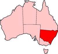
ファイル:NSW in Australia map.png
表示
NSW_in_Australia_map.png (200 × 186 ピクセル、ファイルサイズ: 11キロバイト、MIME タイプ: image/png)
ファイルの履歴
過去の版のファイルを表示するには、その版の日時をクリックしてください。
| 日付と時刻 | サムネイル | 寸法 | 利用者 | コメント | |
|---|---|---|---|---|---|
| 現在の版 | 2004年11月27日 (土) 03:24 |  | 200 × 186 (11キロバイト) | Jeroen | New South Wales location - (from en-two.iwiki.icu) |
ファイルの使用状況
以下のページがこのファイルを使用しています:
グローバルなファイル使用状況
以下に挙げる他のウィキがこの画像を使っています:
- de.wikipedia.org での使用状況
- en-two.iwiki.icu での使用状況
- Ghin-Doo-Ee National Park
- Goulburn River National Park
- Mount Royal National Park
- Towarri National Park
- Wallingat National Park
- Watagans National Park
- See Change Festival
- Swansea, New South Wales
- Australian south-east coast drainage division
- Come By Chance, New South Wales
- Lake Burrendong
- Highways in New South Wales
- Bonshaw, New South Wales
- Shellharbour, New South Wales
- Goolmangar, New South Wales
- Pilliga, New South Wales
- Tooraweenah
- Woodenbong
- Exeter, New South Wales
- Western Division (New South Wales)
- Tarana, New South Wales
- City of Queanbeyan
- Medlow Bath, New South Wales
- Belford, New South Wales
- Mount Hutton, New South Wales
- Clunes, New South Wales
- Goonellabah, New South Wales
- Muster (census)
- Southern Tablelands
- Mount Pleasant, New South Wales
- Narrabri Stellar Intensity Interferometer
- Valla, New South Wales
- Terry Hie Hie, New South Wales
- Milson Island
- Tallimba
- Perrys Lookdown
- Evans Lookout
- Nepean Gorge
- Shark Island (Cronulla Beach)
- Linden, New South Wales
- Capital Country
- Mororo, New South Wales
- Wonboyn Lake
- Horsley, New South Wales
- Cullen Bullen, New South Wales
- Pigeon House Mountain
- Lemon Tree Passage, New South Wales
- Modanville, New South Wales
このファイルのグローバル使用状況を表示する。


