
ファイル:NWS 2013 Moore EF5 damage.jpg
このプレビューのサイズ: 800 × 600 ピクセル。 その他の解像度: 320 × 240 ピクセル | 640 × 480 ピクセル | 1,024 × 768 ピクセル | 1,280 × 960 ピクセル。
元のファイル (1,280 × 960 ピクセル、ファイルサイズ: 1.16メガバイト、MIME タイプ: image/jpeg)
ウィキメディア・コモンズのファイルページにある説明を、以下に表示します。
|
概要
| 解説 |
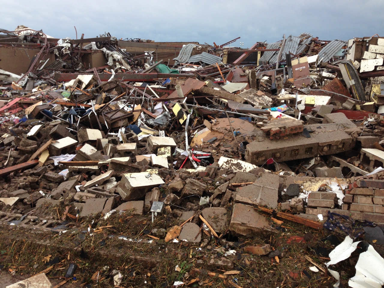
English: 2013 Moore tornado damage at Briarwood Elementary School, EF5 rated by NWS WFO Norman, OK |
| 日付 | |
| 原典 | http://arcgis-nwsdatsecurestd-560264031.us-east-1.elb.amazonaws.com/arcgis/rest/services/DamageAssessmentToolkit/DamageFlexViewer/MapServer/0/141947/attachments/98967 from http://www.srh.noaa.gov/images/oun/wxevents/20130520/20130520-storm_survey_path_points.kmz as linked from http://www.srh.noaa.gov/oun/?n=events-20130520 |
| 作者 | NWS WFO Norman, OK |
| Date of Damage | 05/20/2013 15:48 UTC |
| Date of Survey | 05/21/2013 19:31 UTC |
| EF Rating | EF5 |
| Damage Indicator | Elementary School [Single Story; Interior or Exterior Hallways] (ES) |
| Degree of Damage | Total destruction of a large section of building or entire building |
| Latitude | 35.32133326 |
| Longitude | -97.52087024 |
| カメラの位置 | | 以下のサービスでこの位置を確認する: オープンストリートマップ |
|---|
This File:NWS_2013_Moore_EF5_damage.jpg photo is explicitly identified as an example of EF5 damage in the NWS's kml file http://www.srh.noaa.gov/images/oun/wxevents/20130520/20130520-storm_survey_path_points.kmz as linked from http://www.srh.noaa.gov/oun/?n=events-20130520 as retrieved on 2013-06-17.
ライセンス
This file is in the public domain in the United States because it was solely created by employees of the National Weather Service or National Severe Storms Laboratory using the Damage Assessment Toolkit (DAT), an interactive map and database.
|
ファイルの履歴
過去の版のファイルを表示するには、その版の日時をクリックしてください。
| 日付と時刻 | サムネイル | 寸法 | 利用者 | コメント | |
|---|---|---|---|---|---|
| 現在の版 | 2013年5月22日 (水) 23:30 | | 1,280 × 960 (1.16メガバイト) | Sitic | {{Information |Description ={{en|1=2013 Moore tornado damage at Briarwood Elementary School, EF5 rated by NWS WFO Norman, OK}} |Source =http://arcgis-nwsdatsecurestd-560264031.us-east-1.elb.amazonaws.com/arcgis/rest/services/DamageAssessment... |
ファイルの使用状況
以下の 2 ページがこのファイルを使用しています:
グローバルなファイル使用状況
以下に挙げる他のウィキがこの画像を使っています:
- am.wikipedia.org での使用状況
- ca.wikipedia.org での使用状況
- cs.wikipedia.org での使用状況
- da.wikipedia.org での使用状況
- de.wikipedia.org での使用状況
- en-two.iwiki.icu での使用状況
- gl.wikipedia.org での使用状況
- it.wikipedia.org での使用状況
- nl.wikipedia.org での使用状況
- ru.wikipedia.org での使用状況
- ta.wikipedia.org での使用状況
- zh-two.iwiki.icu での使用状況