
ファイル:San Francisquito Reservoir on topo v2.jpg
このプレビューのサイズ: 783 × 600 ピクセル。 その他の解像度: 313 × 240 ピクセル | 627 × 480 ピクセル | 1,003 × 768 ピクセル | 1,280 × 981 ピクセル | 2,560 × 1,961 ピクセル | 3,065 × 2,348 ピクセル。
元のファイル (3,065 × 2,348 ピクセル、ファイルサイズ: 4.46メガバイト、MIME タイプ: image/jpeg)
ウィキメディア・コモンズのファイルページにある説明を、以下に表示します。
|
概要
| 解説 |
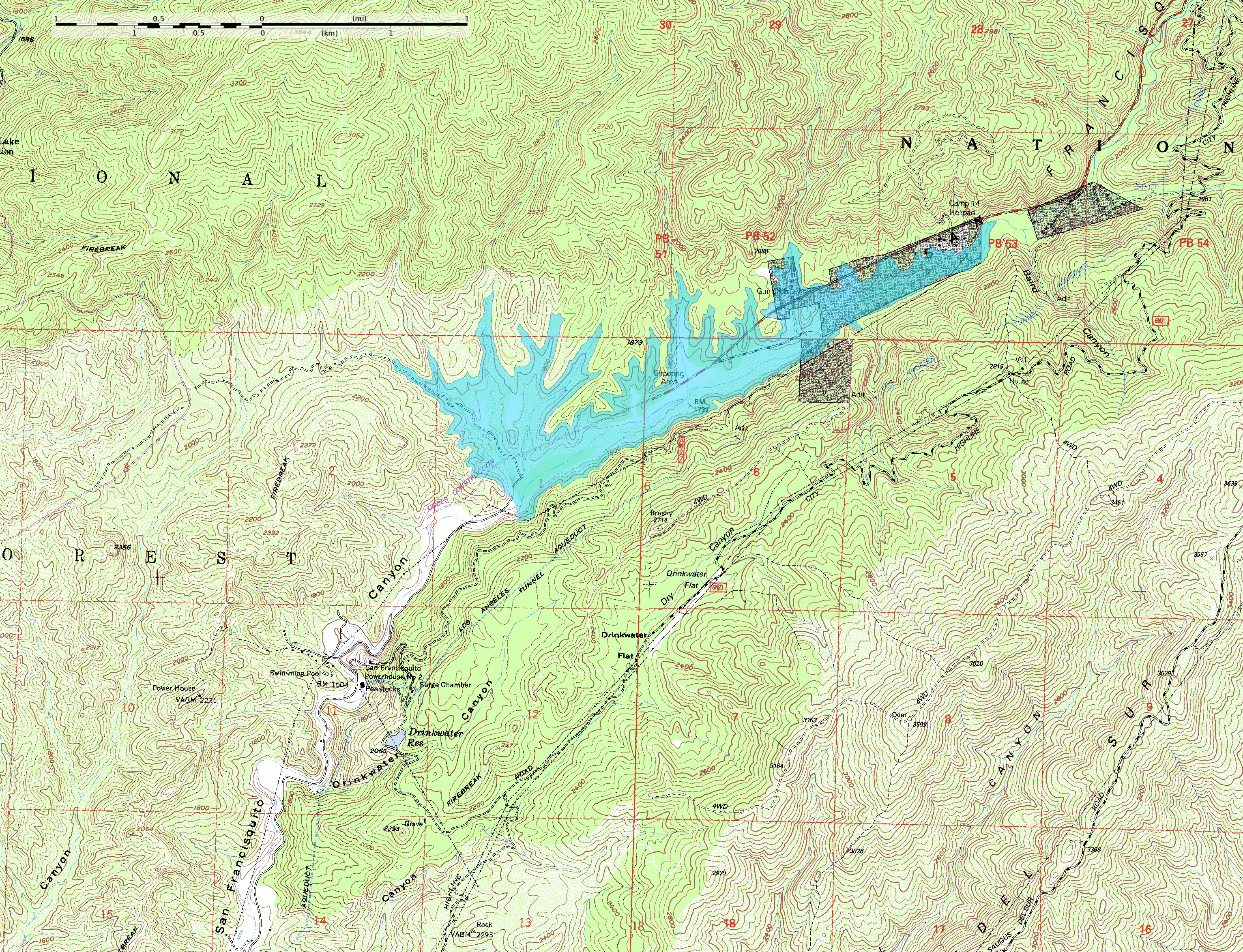
English: This map shows the approximate extent of the former San Francisquito Reservoir. The reservoir was impounded by the St. Francis Dam which failed in 1928. According to this depiction the reservoir was approximately 2.8 miles (4.5 km) long. In addition to the reservoir this map also shows the location of part of the Los Angeles Aqueduct from which it was filled; it was built as a storage stucture for the aqueduct. Also visible on the map at full size is the location of Powerhouse #2 which figures in the story of the flood created by the failure of the dam. The dark blocks indicate private inholdings in the national forest.
The reservoir extent was determined by tracing at or just below the 1840-foot elevation contour; the pool elevation was about 1835 feet when full and when the dam collapsed. The topo map includes sections of the Warm Springs Mountain 7.5" quadrangle (o34118e5) and the Green Valley quadrangle (o34118e4) from the USGS obtained as DRG files. Note: The location and orientation of the dam (at the southwest extent of the reservoir) is approximate. Additionally, the elevation data in this map is from after the breach of the dam, which caused significant erosion of the hillside at the southeast abuttment; the dam was probably a little smaller than this reconstruction depicts. |
| 日付 | |
| 原典 | 投稿者自身による著作物 |
| 作者 | Kbh3rd |
| その他のバージョン |
 |
| カメラの位置 | | 以下のサービスでこの位置を確認する: オープンストリートマップ |
|---|
ライセンス
この作品の著作権者である私は、この作品を以下のライセンスで提供します。
このファイルはクリエイティブ・コモンズ 表示-継承 3.0 非移植ライセンスのもとに利用を許諾されています。
- あなたは以下の条件に従う場合に限り、自由に
- 共有 – 本作品を複製、頒布、展示、実演できます。
- 再構成 – 二次的著作物を作成できます。
- あなたの従うべき条件は以下の通りです。
- 表示 – あなたは適切なクレジットを表示し、ライセンスへのリンクを提供し、変更があったらその旨を示さなければなりません。これらは合理的であればどのような方法で行っても構いませんが、許諾者があなたやあなたの利用行為を支持していると示唆するような方法は除きます。
- 継承 – もしあなたがこの作品をリミックスしたり、改変したり、加工した場合には、あなたはあなたの貢献部分を元の作品とこれと同一または互換性があるライセンスの下に頒布しなければなりません。

|
この文書は、フリーソフトウェア財団発行のGNUフリー文書利用許諾書 (GNU Free Documentation License) 1.2またはそれ以降のバージョンの規約に基づき、複製や再配布、改変が許可されます。不可変更部分、表紙、背表紙はありません。このライセンスの複製は、GNUフリー文書利用許諾書という章に含まれています。 |
あなたは上記のライセンスから、どれか一つ以上を選択できます。
ファイルの履歴
過去の版のファイルを表示するには、その版の日時をクリックしてください。
| 日付と時刻 | サムネイル | 寸法 | 利用者 | コメント | |
|---|---|---|---|---|---|
| 現在の版 | 2009年6月8日 (月) 04:12 | | 3,065 × 2,348 (4.46メガバイト) | Kbh3rd | {{Information |Description={{en|1=This map shows the approximate extent of the former San Francisquito Reservoir. The reservoir was impounded by the St. Francis Dam which failed in 1928. According to this depiction the reservoir |
ファイルの使用状況
以下のページがこのファイルを使用しています:
グローバルなファイル使用状況
以下に挙げる他のウィキがこの画像を使っています:
- de.wikipedia.org での使用状況
- en-two.iwiki.icu での使用状況
- fr.wikipedia.org での使用状況