
ファイル:Stad Amsterdam in Nieuw Nederland (City Amsterdam in New Netherland) Castello Plan 1660.jpg

このプレビューのサイズ: 800 × 600 ピクセル。 その他の解像度: 320 × 240 ピクセル | 640 × 480 ピクセル | 1,024 × 768 ピクセル | 1,280 × 960 ピクセル | 2,560 × 1,920 ピクセル | 3,888 × 2,916 ピクセル。
元のファイル (3,888 × 2,916 ピクセル、ファイルサイズ: 4.28メガバイト、MIME タイプ: image/jpeg)
ウィキメディア・コモンズのファイルページにある説明を、以下に表示します。
|
_Castello_Plan_1660.jpg?uselang=ja)
_Castello_Plan_1660.jpg?uselang=ja)
_Castello_Plan_1660.jpg?uselang=ja&action=history)
_Castello_Plan_1660.jpg)
概要
| 解説 |
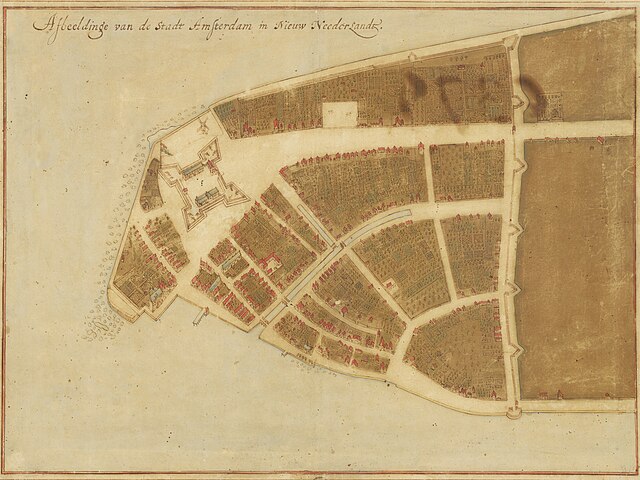
English: Map of New Amsterdam in New Netherland (Manhattan), 1660. Title: "Afbeeldinge van de Stadt Amsterdam in Nieuw Neederlandt." Made by Johannes Vingboons (1616-1670), a cartographer of the VOC. Based on surveys by Jacques Cortelyou (1625–1693). The Grand Duke of Tuscany, Cosimo III de’ Medici (1642-1723), travelled to Amsterdam, the Netherlands in 1667. He was fascinated by Vingboons' work and bought watercolor paintings with mediation by Pieter Blaeu (1637-1706). The paintings were exhibited in his Florentine Villa di Castello.[1] |
| 日付 | |
| 原典 | New York Historical Society - https://www.nyhistory.org/exhibitions/new-york-before-new-york-the-castello-plan . Image url: https://web.archive.org/web/20240212181141/https://images.prismic.io/nyhs-prod/3016cf7a-44f1-484c-9de7-53facb6ab21a_Carte+di+Castello+18.jpg The map (Carte di Castello 18) is at Biblioteca Medicea Laurenziana, Florence. |
| 作者 | Johannes Vingboons (cartographer), Jacques Cortelyou (surveyor) |
| その他のバージョン |
 |
ライセンス
|
この著作物は、著作権の保護期間が著作者の死後100年以下である国・地域においてパブリックドメインの状態にあります。 | |
| このファイルは著作権法の既知の制約(隣接権や関連する権利を含む)から自由であると特定されています。 | |
- ↑ De ontdekking van de wereld. University of Groningen Library (October 2, 2019). Archived from the original on June 29, 2022.
ファイルの履歴
過去の版のファイルを表示するには、その版の日時をクリックしてください。
| 日付と時刻 | サムネイル | 寸法 | 利用者 | コメント | |
|---|---|---|---|---|---|
| 現在の版 | 2024年4月13日 (土) 03:34 | | 3,888 × 2,916 (4.28メガバイト) | User-duck | Cropped borders to center using CropTool with lossless mode. |
| 2024年2月12日 (月) 18:52 |  | 4,000 × 3,070 (4.54メガバイト) | Artanisen | Corrected brightness and contrast | |
| 2024年2月12日 (月) 16:59 |  | 4,000 × 3,070 (4.2メガバイト) | Artanisen | Uploaded a work by Johannes Vingboons (VOC-cartographer), Jacques Cortelyou (surveyor) from New York Historical Society - https://www.nyhistory.org/exhibitions/new-york-before-new-york-the-castello-plan . Image url: https://images.prismic.io/nyhs-prod/3016cf7a-44f1-484c-9de7-53facb6ab21a_Carte+di+Castello+18.jpg with UploadWizard |
ファイルの使用状況
以下の 4 ページがこのファイルを使用しています:
グローバルなファイル使用状況
以下に挙げる他のウィキがこの画像を使っています:
- arz.wikipedia.org での使用状況
- de.wikipedia.org での使用状況
- en-two.iwiki.icu での使用状況
- New Amsterdam
- Peter Stuyvesant
- Wall Street
- Manhattan
- Financial District, Manhattan
- New York City
- Whitehall Street
- List of cities with defensive walls
- Castello Plan
- Jacques Cortelyou
- List of coastal fortifications of the United States
- New Netherland settlements
- Jan Everts Bout
- Harbor Defenses of New York
- Manhattoe
- Cartography of New York City
- History of Manhattan
- en.wikivoyage.org での使用状況
- es.wikipedia.org での使用状況
- fi.wikipedia.org での使用状況
- fr.wikipedia.org での使用状況
- gu.wikipedia.org での使用状況
- gv.wikipedia.org での使用状況
- he.wikipedia.org での使用状況
- hi.wikipedia.org での使用状況
- hu.wikipedia.org での使用状況
- hy.wikipedia.org での使用状況
- id.wikipedia.org での使用状況
- it.wikipedia.org での使用状況
- kn.wikipedia.org での使用状況
- ko.wikipedia.org での使用状況
- la.wikipedia.org での使用状況
- mai.wikipedia.org での使用状況
このファイルのグローバル使用状況を表示する。
_Castello_Plan_1660.jpg)
_Castello_Plan_1660.jpg)