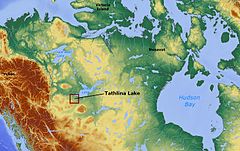
タスリナ湖
表示
| タスリナ湖 | |
|---|---|
 | |
| 位置 | ノースウエスト準州 |
| 座標 | 北緯60度33分 西経117度32分 / 北緯60.550度 西経117.533度座標: 北緯60度33分 西経117度32分 / 北緯60.550度 西経117.533度 |
| 主な流入 | カキサ川 |
| 国 |
|
| 面積 | 573.4 km2 (221.4 sq mi)[1][2] |
| 平均水深 | 1 メートル |
| 水面標高 | 280 m (920 ft)[2] |
タスリナ湖(タスリナこ、英語: Tathlina Lake)は、カナダ、ノースウエスト準州にある湖。
ノースウェスト準州で15番目に大きく[3]、標高は269m、平均水深は1mしかない。面積は573.4㎢[4][2]。
マッケンジー川支流のカキサ川が西から流入し、北から流出している。
1953年からウォールアイの商業漁獲が行われてきたが、1960年代から1990年代に漁獲量が悪化し、2000年からは行われていない[5]。
脚注
[編集]- ^ Northwest Territory Fishing, Northwest Territory Canada Fly In Fishing Trips Archived 2010年11月20日, at the Wayback Machine.
- ^ a b c Tathlina Lake | World Lakes Database - ILEC Archived 2011年9月2日, at the Wayback Machine.
- ^ The Atlas of Canada - Lakes
- ^ Northwest Territory Fishing, Northwest Territory Canada Fly In Fishing Trips Archived 2010年11月20日, at the Wayback Machine.
- ^ Canadian Science Advisory Secretariat - CSAS
