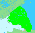
ファイル:La2-demis-karelian-isthmus.png
表示

このプレビューのサイズ: 623 × 600 ピクセル。 その他の解像度: 249 × 240 ピクセル | 499 × 480 ピクセル | 903 × 869 ピクセル。
元のファイル (903 × 869 ピクセル、ファイルサイズ: 344キロバイト、MIME タイプ: image/png)
ファイルの履歴
過去の版のファイルを表示するには、その版の日時をクリックしてください。
| 日付と時刻 | サムネイル | 寸法 | 利用者 | コメント | |
|---|---|---|---|---|---|
| 現在の版 | 2020年4月22日 (水) 20:56 |  | 903 × 869 (344キロバイト) | Yrsari | Reverted to version as of 20:01, 10 April 2020 (UTC) |
| 2020年4月17日 (金) 22:02 |  | 720 × 694 (69キロバイト) | Jonteemil | COM:OVERWRITE Reverted to version as of 20:46, 6 April 2020 (UTC) | |
| 2020年4月10日 (金) 20:01 |  | 903 × 869 (344キロバイト) | Yrsari | Reverted to version as of 19:16, 31 March 2020 (UTC): The area of Karelian Isthmus with light green. | |
| 2020年4月6日 (月) 20:46 |  | 720 × 694 (69キロバイト) | Jonteemil | COM:OVERWRITE Reverted to version as of 00:33, 6 November 2012 (UTC) | |
| 2020年3月31日 (火) 19:16 |  | 903 × 869 (344キロバイト) | Yrsari | The area of Karelian Isthmus with light green. | |
| 2012年11月6日 (火) 00:33 |  | 720 × 694 (69キロバイト) | P. S. Burton | removed watermark | |
| 2005年8月30日 (火) 11:28 |  | 720 × 694 (72キロバイト) | LA2 | Karelian Isthmus between lake Ladoga and the Gulf of Finland. {{demis-pd}} category:Maps of Finland category:Maps of Russia |
ファイルの使用状況
以下の 4 ページがこのファイルを使用しています:
グローバルなファイル使用状況
以下に挙げる他のウィキがこの画像を使っています:
- da.wikipedia.org での使用状況
- en-two.iwiki.icu での使用状況
- es.wikipedia.org での使用状況
- et.wikipedia.org での使用状況
- fiu-vro.wikipedia.org での使用状況
- fi.wikipedia.org での使用状況
- fr.wikipedia.org での使用状況
- it.wikipedia.org での使用状況
- la.wikipedia.org での使用状況
- nn.wikipedia.org での使用状況
- no.wikipedia.org での使用状況
- ru.wikipedia.org での使用状況
- sr.wikipedia.org での使用状況
- zh-two.iwiki.icu での使用状況
