
ファイル:Los Alamos Tech Area Map.jpg
高解像度版はありません。
Los_Alamos_Tech_Area_Map.jpg (600 × 302 ピクセル、ファイルサイズ: 46キロバイト、MIME タイプ: image/jpeg)
ウィキメディア・コモンズのファイルページにある説明を、以下に表示します。
|
概要
| 解説 |
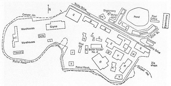
English: Map of Los Alamos Tech Area c. 1945 |
| 日付 | 1985年頃 |
| 原典 | https://www.osti.gov/opennet/manhattan-project-history/Resources/photo_gallery/tech_area_large.htm |
| 作者 | Los Alamos National Laboratory |
| 許可 (ファイルの再利用) |
This information has been authored by an employee or employees of the Los Alamos National Security, LLC (LANS), operator of the Los Alamos National Laboratory under Contract No. DE-AC52-06NA25396 with the U.S. Department of Energy. The U.S. Government has rights to use, reproduce, and distribute this information. The public may copy and use this information without charge, provided that this Notice and any statement of authorship are reproduced on all copies. Neither the Government nor LANS makes any warranty, express or implied, or assumes any liability or responsibility for the use of this information. |
ライセンス
| この画像は、アメリカ合衆国エネルギー省(又はその前身機関)の職員が公務の一環として撮影し、又は作成した著作物です。アメリカ合衆国連邦政府の著作物として、この画像はパブリックドメインの状態にあります。
国家研究所は様々なライセンスの下で運営されており、フリーライセンスでないものもあることにご注意ください。このタグでクレジットを記載する前に、各国立研究所のサイトポリシーをご確認ください。
|

|
ファイルの履歴
過去の版のファイルを表示するには、その版の日時をクリックしてください。
| 日付と時刻 | サムネイル | 寸法 | 利用者 | コメント | |
|---|---|---|---|---|---|
| 現在の版 | 2017年2月11日 (土) 21:35 | | 600 × 302 (46キロバイト) | Hawkeye7 | User created page with UploadWizard |
ファイルの使用状況
以下のページがこのファイルを使用しています:
グローバルなファイル使用状況
以下に挙げる他のウィキがこの画像を使っています:
- ar.wikipedia.org での使用状況
- en-two.iwiki.icu での使用状況
- hu.wikipedia.org での使用状況
- uk.wikipedia.org での使用状況