中央アメリカ海溝
表示


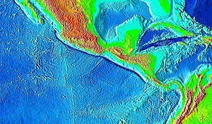
中央アメリカ海溝(ちゅうおうアメリカかいこう、Middle America Trench)とは東太平洋にある海溝で、メキシコからコスタリカにかけての中南米の南西沖にある沈み込み帯である。海溝の長さは2750キロメートル、深さは最深部で6,669メートル。世界で18番目に深い海溝である。
この海溝は太平洋プレート、リベラプレート、ココスプレート、ナスカプレートと北アメリカプレート、カリブプレートとの境界になっている。1985年のメキシコ地震をはじめ、しばしば大地震が発生している[1]。
中央アメリカ海溝は北部と南部に分けられる。しかしながら境目は海側と陸側で違っている。海側の北部はアカプルコ海溝と呼ばれ、ハリスコ州からTehuantepec海嶺までである。海側の南部はグアテマラ海溝とよばれ、Tehuantepec海嶺からココス海嶺までである[2]。
陸側ではPolochic-Motagua断層が境目になっている(Polochic-Motagua断層は北アメリカプレートとカリブプレートの境目でもある)[3]。陸側の分岐点は海側の分岐点よりもおよそ400キロメートル東にある[4]。
出典
[編集]- ^ “Source characteristics of earthquakes in the Michoacan seismic gap in Mexico”. Bulletin of the Seismological Society of America 77 (4): 1326–1346. (1987). オリジナルの2011年6月14日時点におけるアーカイブ。.
- ^ Marina Manea, Vlad C. Manea, Vladimir Kostoglodov (2003). “Sediment Fill In the Middle America Trench Inferred From Gravity Anomalies”. America 42: 603–612.
- ^ Lyon-Caen, H.; Barrier, E.; Lasserre, C.; Franco, A.; Arzu, I.; Chiquin, L.; Chiquin, M.; Duquesnoy, T. et al. (2006). “Kinematics of the North American–Caribbean-Cocos plates in Central America from new GPS measurements across the Polochic-Motagua fault system”. Geophysical Research Letters 33 (19). doi:10.1029/2006GL027694.
- ^ Aubouin, J.; Azema, J.; Carfantan, J.-Ch.; Demant, A.; Rangin, C.; Tardy, M.; Tournon, J. (1982). “The Middle America Trench in the Geological Framework of Central America”. Initial Reports of the Deep Sea Drilling Project, 67. Initial Reports of the Deep Sea Drilling Project. 67. doi:10.2973/dsdp.proc.67.141.1982.
