
利用者:ツバル/sandbox/Saxon Switzerland
.jpg)


Saxon Switzerland (ドイツ語: Sächsische Schweiz) is a hilly climbing area and national park around the Elbe valley south-east of Dresden in Saxony, Germany. Together with the Bohemian Switzerland in the Czech Republic it forms the Elbe Sandstone Mountains.
Saxon Switzerland alone has some 1,000 climbing peaks, as well as several hollows. The area is popular with Dresden locals and international climbers.
The administrative district for the area is Sächsische Schweiz-Osterzgebirge. The fortress of Königstein is a well-known landmark.
Derivation of the name
[編集]The German name for Saxon Switzerland, Sächsische Schweiz, appeared in the 18th century. Two Swiss artists, Adrian Zingg and Anton Graff, were appointed in 1766 to the Dresden Academy of Art.
They felt the landscape was reminiscent of their homeland, the Swiss Jura, and reported in their exchange of letters on the difference between their homeland and "Saxon Switzerland". Previously, the Saxon part of the Elbe Sandstone Mountains had merely been referred to as the Meissen Highlands (Meißner Hochland), Meissen Oberland (Meissen Oberland) or Heath above Schandau (Heide über Schandau).[1]
The description became popular through the publication of the name by Wilhelm Lebrecht Götzinger. In his books he described the area as Saxon Switzerland and made the term known to a wide audience.
In English the usual translation is "Saxon Switzerland".[2][3][4][5] However other sources call it "Saxony Switzerland"[6] or even "Swiss Saxony".[7]
Geography
[編集]
To the east, Saxon Switzerland transitions into the Lusatian Highlands and, to the west, into the Ore Mountains. The adjacent Czech part of the Elbe Sandstone Mountains is known as the Bohemian Switzerland. The highest elevation in Saxon Switzerland is the Großer Zschirnstein at 562 m above sea level.
History
[編集]

During the Dark Ages, the region was settled by Slavs and was part of the Kingdom of Bohemia during the Middle Ages. About 1000 years ago Bohemian-Saxon Switzerland was the borderland of three Slavic tribes. The Nisane tribe (east of the Elbe from Dresden to Pirna), the Milzane tribe (from today's Upper Lusatia) and in the south the Dacine tribe shaped the political and economic landscape at that time.
It was not until the 15th century that the area now called Saxon Switzerland came under Saxon hegemony when it became part of the Margraviate of Meissen with boundaries roughly corresponding to those of today.
The development of the area for tourism began in earnest in the 19th century. In connexion with that, one of the first trolleybus lines in the world was opened in Saxon Switzerland, the Biela Valley Trolleybus, that was in operation from 1901 to 1904 and worked out of Königstein.
Romantic artists were inspired by the beauty of wilderness, like the painter Ludwig Richter or the composer Carl Maria von Weber, who set his famous opera Der Freischütz with its Wolfsschlucht ("Wolf's Gorge") scene set near the town of Rathen.
In the Nazi era the description of German territories as Schweiz ("Switzerland") was officially banned. For that reason, with effect from 19 October 1938, the official term "Sächsische Schweiz" was replaced by "Amtshauptmannschaft Pirna" and from January 1939 by "Kreis Pirna" in the names of the local places of Königstein, Obervogelgesang, Ottendorf, Porschdorf, Rathen, Rathewalde, Rathmannsdorf and Reinhardtsdorf.[8]
National park
[編集]
In September 1990, even before the reunification of Germany, a national park was created in Saxon Switzerland in order to protect the unique natural character of the hill range. The 93 km² area covers two physically separate regions: one near Rathen - the region of the Bastei, Polenz valley, Brand and Uttewalder Grund - and the other embracing the whole Saxon Switzerland Hinterland (Hintere Sächsische Schweiz) between the Elbe and the state border with the Czech Republic and including the Schrammsteinen, Großer Winterberg, Großer Zschand and Kirnitzsch valley.
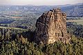
Points of interest
[編集]_2006-03-25.jpg)


- Bastei and Neurathen Castle
- Bärensteine and Rauenstein near Weißig
- Biela Valley
- Stolpen Castle
- Ruins of Wehlen Castle
- Rock arch near Wehlen
- Frienstein and the Ida Grotto
- Mount Gohrisch with its refuge hut
- Kaiserkrone and Zirkelstein
- Kirnitzschtal Tramway, an historic interurban in the Kirnitzsch valley
- Little Saxon Switzerland, a miniature park layout in the village of Wehlen
- Königstein Fortress, the largest hill fortress in Europe
- Kuhstall on the New Wildenstein
- Lilienstein, Schrammsteine
- Obere Schleuse, boat trip near Hinterhermsdorf
- Rathen Open-Air Stage, an open-air theatre
- Papststein with observation tower and restaurant
- Pfaffenstein and the Barbarine
- Wolfsberg
- Bad Schandau Botanical Gardens, a regional botanical garden
Panorama
[編集]

See also
[編集]- Portal:Elbe Sandstone Mountains
- Saxon Switzerland National Park
- Elbe Sandstone Mountains
- List of regions of Saxony
Photos
[編集]-
 View from the Bastei
 -
 View of the Elbe River from Bastei
 -
 View from Königstein fortress to Lilienstein and Elbe
 -
 Falkenstein
 -
 Climbing in the Biela valley
 -
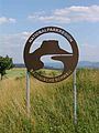 National Park sign


.jpg)


References
[編集]- ^ Sieghard Liebe, Lothar Kempe: Sächsische Schweiz und Ausflüge in die Böhmische Schweiz.
- ^ Kohl, Horst; Marcinek, Joachim and Nitz, Bernhard (1986).
- ^ Baedeker (2010).
- ^ Saxon Switzerland at www.saechsische-schweiz.de.
- ^ Saxon Switzerland at www.ceskosaske-svycarsko.cz.
- ^ Saxony Switzerland at www.saxony-switzerland.de/ Accessed on 9 Sep 2011.
- ^ Ochterbeck, Cynthia Clayton (ed. dir.) et al. (2010), Germany, Michelin Green Guide, Watford UK and Greenville, SC, 2010, p. 480.
- ^ Statistik des Deutschen Reichs, Band 450: Amtliches Gemeindeverzeichnis für das Deutsche Reich, Teil I, Berlin 1939; page 272
Sources
[編集]- Autorenkollektiv: Brockhaus Reisehandbuch Sächsische Schweiz – Osterzgebirge. Leipzig 1970.
- Wilhelm Lebrecht Götzinger: Schandau und seine Umgebungen, oder Beschreibung der Sächsischen Schweiz. Begersche Buch- und Kunsthandlung, Dresden 1812.
- Heinz Klemm: Die Entdeckung der Sächsischen Schweiz. Sachsenverlag, Dresden 1953.
- Alfred Meiche: Die Burgen und vorgeschichtlichen Wohnstätten der Sächsischen Schweiz. Wilhelm Baensch Verlagsbuchhandlung, Dresden 1907. (Reprint Leipzig 1979)
- Alfred Meiche: Historisch-topographische Beschreibung der Amtshauptmannschaft Pirna. Dresden 1927.