利用者:Atirow/ケルゲレン海台
en:Kerguelen Plateau (22:14, 9 August 2009 UTC)

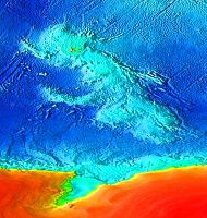
The Kerguelen Plateau (発音: [ˈkɜrɡələn, kərˈɡeɪlən][1]) is an underwater volcanic large igneous province (LIP) in the southern Indian Ocean. It lies about 3,000 km to the southwest of Australia and is nearly three times the size of Japan. The plateau extends for more than 2,200 km in a northwest-southeast direction and lies in deep water.
ケルゲレン海台(ケルゲレンかいだい、英:Kerguelen Plateau、IPA 発音:/ˈkɜrɡələn, kərˈɡeɪlən/[2])は南インド洋にある海底の火山岩の巨大火成岩岩石区(LIP)である。オーストラリアの南西およそ3,000 kmの位置にあり、日本の3倍近い大きさである。この海台は北西-南東方向に2,200 kmに渡って延びており、深海に横たわっている。
The plateau was produced by the Kerguelen hotspot, starting with or following the breakup of Gondwanaland about 130 million years ago. There is a small portion of the plateau that breaks sea level, forming the Kerguelen Islands, Heard Island and the McDonald Islands. Intermittent volcanism continues on Heard and McDonald islands.
この海台はおよそ1億3000万年前にゴンドワナランドの分裂とともに、あるいはそれに続いてケルゲレンホットスポットによって造られた。海台の一部は海面よりも高く、ケルゲレン諸島、ハード島とマクドナルド諸島を形成している。断続的な火山活動がハード島とマクドナルド諸島で続いている。
地理的範囲
[編集]Symmetrically located across the Indian Ocean ridge and due west of Australia, is the Broken Ridge underwater volcanic plateau which was at one time contiguous with the Kerguelen Plateau prior to rifting by the mid-ocean ridge.
オーストラリアの真西、インド洋海嶺を挟んで対称的な位置にあるブロークン海嶺は、海底の火山性台地であり、中央海嶺によって分裂させられる前はかつてケルゲレン海台と繋がっていた。
To the north of Broken Ridge lies the linear Ninety East Ridge which continues almost due north into the Bay of Bengal and is considered to be a hotspot track.
ブロークン海嶺の北には直線的な東経90度海嶺がベンガル湾までほとんど真北に続いており、ホットスポットの跡であると考えられている。

ケルゲレン微小大陸
[編集]The Kerguelen Plateau was formed starting 110 million years ago from a series of large volcanic eruptions. The presence of soil layers in the basalt with included charcoal and conglomerate fragments of gneiss indicate that much of the plateau was above sea level as what is termed a microcontinent for three periods between 100 million years ago and 20 million years ago.
ケルゲレン海台は1億1000万年前から始まる一連の巨大火山噴火によって形成された。玄武岩中の炭や片麻岩の礫岩片を含む土層の存在は、海台のかなりの部分が、1億年前から2000万年前までの間の3つの期間に、微小大陸と呼ばれるような海面より高い状態にあったことを示している。
The so-called Kerguelen microcontinent may have been covered by dense conifer forest in the mid-Cretaceous.[3] It finally sank 20 million years ago and is now 1–2 km (0.62–1.24 mi) below sea level. It has sedimentary rocks similar to the ones found in Australia and India, suggesting they were once connected.
ケルゲレン微小大陸は白亜紀の中期には濃い針葉樹林に覆われていた可能性がある。[4]それは最終的に2000万年前に沈み、現在海面下1–2 km (0.62–1.2 mi)にある。ここにはオーストラリアやインドで見つかったものとよく似た堆積岩があり、これらの大陸がかつて繋がっていたことを示唆している。
参照文献
[編集]- ^ OED
- ^ OED
- ^ Mohr, Barbara A.R.; Veronika Wähnert, and David Lazarus "Mid-Cretaceous paleobotany and palynology of the central Kerguelen Plateau, southern Indian Ocean (ODP Leg 183, Site 1138)". In Frey, F.A., Coffin, M.F., Wallace, P.J., and Quilty, P.G. (Eds.), Proc. ODP, Sci. Results, 183 Sept 2002 [1]
- ^ Mohr, Barbara A.R.; Veronika Wähnert, and David Lazarus "Mid-Cretaceous paleobotany and palynology of the central Kerguelen Plateau, southern Indian Ocean (ODP Leg 183, Site 1138)". In Frey, F.A., Coffin, M.F., Wallace, P.J., and Quilty, P.G. (Eds.), Proc. ODP, Sci. Results, 183 Sept 2002 [2]
- UT Austin scientist plays major role in study of underwater "micro-continent"
- Leg 183 Summary: Kerguelen Plateau-Broken Ridge—A Large Igneous Province
- KERGUELEN PLATEAU—BROKEN RIDGE: A MAJOR LIP RELATED TO THE KERGUELEN PLUME.
関連項目
[編集]関係するトピック
